


Summary
Batan Island (/bɑːˈtɑːn/ bah-TAHN[4]) is the main island of Batanes, an archipelagic province in the Philippines. It is the second largest of the Batanes Islands, the northernmost group of islands in the Philippines.
 | |
 Batan Island Location within Batanes  Batan Island Batan Island (Luzon)  Batan Island Batan Island (Philippines) | |
| Geography | |
|---|---|
| Location | Luzon Strait |
| Coordinates | 20°25′17″N 121°57′37″E / 20.42139°N 121.96028°E |
| Archipelago | Batanes Islands |
| Adjacent to | |
| Area | 95.18 km2 (36.75 sq mi)[1] |
| Length | 20 km (12 mi)[2] |
| Width | 6.5 km (4.04 mi) at its widest |
| Highest elevation | 1,009 m (3310 ft)[2] |
| Highest point | Mount Iraya |
| Administration | |
| Region | Cagayan Valley |
| Province | Batanes |
| Municipalities | |
| Demographics | |
| Population | 14,007 (2020 est.)[3] |
| Pop. density | 134/km2 (347/sq mi) |
| Ethnic groups | Ivatans |
| Additional information | |
|
Geography
edit
Batan is a dumbbell-shaped volcanic island, part of the Luzon Volcanic Arc. The northern part of the island is dominated by the 1,009-meter (3,310 ft) high active volcano, Mount Iraya, which last erupted in 1454.[2] The lower portion of the island is the inactive volcano Mount Matarem, about 405 meters (1,329 ft) tall.[5][6] A hilly narrow neck of land, about 4.5 kilometers (2.8 mi) long and from 1.9 to 2.5 kilometers (1.2 to 1.6 mi) wide, separates the two volcanoes of the island. Near Mt. Matarem, the island is at its widest at about 6.5 kilometers (4.0 mi). Sabtang Island, the nearest island to Batan is located about 4.5 kilometers (2.8 mi) southwest of the southern tip of the island. Itbayat, the largest island of the archipelago, is about 32 kilometers (20 mi) northwest of the central part of Batan. Geology editThe Batan Volcanic Complex includes the Pliocene Matarem composite volcano of basalt and andesite flows, 5.8 to 1.7 Ma, on the southern part of the island, and the Quaternary Mt. Iraya basalt and andesite lava flows on the northern part of the island. The central isthmus has an outcrop of Late Miocene andesitic flows, 9 - 7 Ma. Western Mt. Iraya has a pyroclastic flow deposit dated 1,480 years B.P., that includes ash and pumice. The periphery of Mt. Matarem includes lahar and tuffaceous deposits. The Miocene Batan Group are sedimentary rocks that includes the Liguan, Caracaran and Bilbao formations. The Middle Miocene Bilbao limestone overlies the Early Miocene Caracaran siltstone, which overlies the Liguan limestone. The Liguan and Bilbao include coal measures up to 300 meters thick.[7][8] History editJapanese invasion editThe Japanese invasion of the Philippines began with the invasion of Batan Island by a 490-man naval combat unit and an indeterminate number of air corps troops, on two transports escorted by one destroyer and four torpedo boats. This was the first landing on American territory, the same day as the attack on Pearl Harbor.[9] Japanese forces quickly secured the existing small airfield outside Basco without resistance and began expansion work immediately as a forward base for operations against Luzon. Work was discontinued only a few days later as the success of the Japanese bombing of Clark Field rendered a base at Basco redundant. On 10 December 1941, the naval combat force was withdrawn.[10] Governance editFour of the six municipalities of Batanes are located on the 20-kilometer (12 mi) long island including the provincial capital of Basco. The other municipalities are Ivana, Mahatao and Uyugan. See also editReferences edit
External links edit 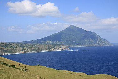
| |