


Summary
Bautista, officially the Municipality of Bautista (Pangasinan: Baley na Bautista; Ilocano: Ili ti Bautista; Tagalog: Bayan ng Bautista), is a 4th class municipality in the province of Pangasinan, Philippines. According to the 2020 census, it has a population of 35,398 people.[3]
Bautista | |
|---|---|
| Municipality of Bautista | |
 Arch of welcome and Municipal hall | |
 Seal | |
 Map of Pangasinan with Bautista highlighted | |
OpenStreetMap .mw-parser-output .locmap .od{position:absolute}.mw-parser-output .locmap .id{position:absolute;line-height:0}.mw-parser-output .locmap .l0{font-size:0;position:absolute}.mw-parser-output .locmap .pv{line-height:110%;position:absolute;text-align:center}.mw-parser-output .locmap .pl{line-height:110%;position:absolute;top:-0.75em;text-align:right}.mw-parser-output .locmap .pr{line-height:110%;position:absolute;top:-0.75em;text-align:left}.mw-parser-output .locmap .pv>div{display:inline;padding:1px}.mw-parser-output .locmap .pl>div{display:inline;padding:1px;float:right}.mw-parser-output .locmap .pr>div{display:inline;padding:1px;float:left}html.skin-theme-clientpref-night .mw-parser-output .od,html.skin-theme-clientpref-night .mw-parser-output .od .pv>div,html.skin-theme-clientpref-night .mw-parser-output .od .pl>div,html.skin-theme-clientpref-night .mw-parser-output .od .pr>div{background:#000;color:#fff}html.skin-theme-clientpref-night .mw-parser-output .locmap{filter:grayscale(0.6)}@media(prefers-color-scheme:dark){html.skin-theme-clientpref-os .mw-parser-output .locmap{filter:grayscale(0.6)}html.skin-theme-clientpref-os .mw-parser-output .od,html.skin-theme-clientpref-os .mw-parser-output .od .pv>div,html.skin-theme-clientpref-os .mw-parser-output .od .pl>div,html.skin-theme-clientpref-os .mw-parser-output .od .pr>div{background:#000;color:#fff}}  Bautista Location within the Philippines | |
| Coordinates: 15°48′37″N 120°28′32″E / 15.8103°N 120.4756°E | |
| Country | Philippines |
| Region | Ilocos Region |
| Province | Pangasinan |
| District | 5th district |
| Founded | May 5, 1900 |
| Named for | John the Baptist |
| Barangays | 18 (see Barangays) |
| Government | |
| • Type | Sangguniang Bayan |
| • Mayor | Joseph G. Espino |
| • Vice Mayor | Rosemarie Gacutan |
| • Representative | Ramon V. Guico III |
| • Municipal Council | Members |
| • Electorate | 22,290 voters (2022) |
| Area | |
| • Total | 46.33 km2 (17.89 sq mi) |
| Elevation | 21 m (69 ft) |
| Highest elevation | 48 m (157 ft) |
| Lowest elevation | 12 m (39 ft) |
| Population (2020 census)[3] | |
| • Total | 35,398 |
| • Density | 760/km2 (2,000/sq mi) |
| • Households | 8,478 |
| Economy | |
| • Income class | 4th municipal income class |
| • Poverty incidence | 14.79 |
| • Revenue | ₱ 113 million (2020) |
| • Assets | ₱ 221.1 million (2020) |
| • Expenditure | ₱ 97.15 million (2020) |
| • Liabilities | ₱ 28.15 million (2020) |
| Service provider | |
| • Electricity | Central Pangasinan Electric Cooperative (CENPELCO) |
| Time zone | UTC+8 (PST) |
| ZIP code | 2424 |
| PSGC | 015510000 |
| IDD : area code | +63 (0)75 |
| Native languages | Pangasinan Ilocano Tagalog |
Bautista is called "The Walis Tambo (broom) Capital of Pangasinan".[5] It is honored as the "Lupang Hinirang".[6]
History edit
Boletin Ecclesiastico de Filipinas published that the Dominicans founded Pangasinan towns of Binalatongan (City of San Carlos, 1588), Calasiao, 1588, Mangaldan, 1600, Manaoag, 1608, Lingayen, 1614, Dagupan, 1614 and Telbang (now Bautista, 1614). A historian, Rosario Cortez, however, wrote that Bautista existed since 1686, but was removed to the Parish of Bayambang.
The "Rebirth of Bautista" as Municipality was only in 1900. Don Ramon Reynado became the first town executive along with other notable founder: Guillermo Agcaoile, Francisco Gonzales, Felipe Ramos, Dionisio Galvan, Teodoro Carungay, Claudio and Antonio Galsim, Marciano Guzman, Nicolas Galsim, Marcelino Villanueva and Eleno Cayabyab.
Bautista was dubbed "mercancia" or "Melting Pot" (where cargoes due to Camiling, Tarlac were traded via the Agno River or by train). The municipality was truly a melting pot, indicative of which is the diversity of people's dialects and languages. The residents of the town were Pangasinenses, Ilocanos, Tagalogs, Pampangos, Chinese and Spanish. The people of Nibaliw, Baluyot and Cabuaan are mostly Pangasinenses. The people of Nandacan, Villanueva, Poponto, Primicias, Artacho and Pogo are predominantly Ilocanos. Within the Poblacion, one would be able to meet a number of people with different persuasions, ideals and expression in varied dialects and language.
Bautista natives' livelihoods are farming, broom making (fiber, tanobong and midribs), dressmaking, sawali making, buro making, building construction, auto mechanics, basketry, bag making, blacksmithing, pottery, ceramics and hollow blocks making and rattan crafts. The residents also have clay, cattle, poultry, bamboo, rattan, anahaw, abiang, fishes, sugar, basi, vinegar and coconut, including watermelon and onion, its principal product.
1907 to 1920 was its golden years until San Quintin-Paniqui rail road line was opened, thus Bautista lost to Rosales, Tayug and San Quintin. The big floods of 1934 and 1972 almost annihilated the flood-prone town.[7]
Alcala March to Righteousness edit
The Alcala December 5, 2012 "March to Righteousness" was launched to have joined the Ombudsman of the Philippines observance of December 9 International Anti-Corruption Day United Nations Convention against Corruption (UNCAC), General Assembly of the United Nations (UN). Recently, Alcala held its Incident Command System Training, the Bautista LGU-Pangasinan, the Malacanang & Google hold MapUp Session, the 23rd National Statistics Month (NSM) and Philippine Civil Service Anniversary 2012.[8]
Geography edit
Bautista is located east of Pangasinan part of the Pangasinan's Fifth Congressional District with a land area of 8,213 hectares. Bautista is bounded by Alcala, Pangasinan, north; Bayambang, south, Agno River and Moncada, Tarlac, east.[5]
Bautista is 43 kilometres (27 mi) from Lingayen and 187 kilometres (116 mi) from Manila.
Barangays edit
Bautista is politically subdivided into 18 barangays:[9] Each barangay consists of puroks and some have sitios.
- Artacho
- Baluyot
- Cabuaan
- Cacandongan
- Diaz
- Nandacan
- Nibaliw Norte
- Nibaliw Sur
- Palisoc
- Poblacion East
- Poblacion West
- Pogo
- Poponto
- Primicias
- Ketegan
- Sinabaan
- Vacante
- Villanueva
Barangay Poblacion West is the site where the lyrics of the Philippine National Anthem were written, and it is known as the "Home of the Philippine National Anthem". In 1899, Jose Palma wrote his poem "Filipinas" which became the Anthem's lyrics.[10]
Climate edit
| Climate data for Bautista, Pangasinan | |||||||||||||
|---|---|---|---|---|---|---|---|---|---|---|---|---|---|
| Month | Jan | Feb | Mar | Apr | May | Jun | Jul | Aug | Sep | Oct | Nov | Dec | Year |
| Mean daily maximum °C (°F) | 31 (88) |
31 (88) |
31 (88) |
33 (91) |
32 (90) |
32 (90) |
30 (86) |
30 (86) |
30 (86) |
31 (88) |
31 (88) |
31 (88) |
31 (88) |
| Mean daily minimum °C (°F) | 21 (70) |
21 (70) |
22 (72) |
24 (75) |
24 (75) |
24 (75) |
23 (73) |
23 (73) |
23 (73) |
23 (73) |
23 (73) |
22 (72) |
23 (73) |
| Average precipitation mm (inches) | 5.1 (0.20) |
11.6 (0.46) |
21.1 (0.83) |
27.7 (1.09) |
232.9 (9.17) |
350.8 (13.81) |
679.8 (26.76) |
733.1 (28.86) |
505 (19.9) |
176.6 (6.95) |
67.2 (2.65) |
17.7 (0.70) |
2,828.6 (111.38) |
| Average rainy days | 3 | 3 | 3 | 4 | 14 | 18 | 23 | 25 | 22 | 15 | 8 | 4 | 142 |
| Source: World Weather Online[11] | |||||||||||||
Demographics edit
| Year | Pop. | ±% p.a. |
|---|---|---|
| 1903 | 6,661 | — |
| 1918 | 5,424 | −1.36% |
| 1939 | 7,203 | +1.36% |
| 1948 | 9,176 | +2.73% |
| 1960 | 12,375 | +2.52% |
| 1970 | 14,985 | +1.93% |
| 1975 | 16,749 | +2.26% |
| 1980 | 18,072 | +1.53% |
| 1990 | 21,280 | +1.65% |
| 1995 | 23,375 | +1.77% |
| 2000 | 27,066 | +3.19% |
| 2007 | 28,094 | +0.52% |
| 2010 | 30,193 | +2.66% |
| 2015 | 32,307 | +1.30% |
| 2020 | 35,398 | +1.81% |
| Source: Philippine Statistics Authority[12][13][14][15] | ||
Economy edit
Government edit
Local government edit
Bautista, belonging to the fifth congressional district of the province of Pangasinan, is governed by a mayor designated as its local chief executive and by a municipal council as its legislative body in accordance with the Local Government Code. The mayor, vice mayor, and the councilors are elected directly by the people through an election which is being held every three years.
Municipal seal edit
The official seal of Bautista has "BAYAN NG BAUTISTA" amid the green color (agricultural area, the gear, farming developments, the carabao).[23]
Elected officials edit
| Position | Name |
|---|---|
| Congressman | Ramon V. Guico III |
| Mayor | Joseph G. Espino |
| Vice-Mayor | Rosemarie G. Gacutan |
| Councilors | Joren Aaron C. Espino |
| Albino D. Mejia Sr. | |
| Simplicio I. Petinez III | |
| Raem V. Aquino | |
| Jesus S. Villanueva Jr | |
| Alex S. Tagulao | |
| Alfredo P. Laguardia | |
| Ramiro Sagum |
Tourism edit

Bautista celebrates Philippine Eagle Week from June 4, 2012, to June 10, 2012 (Presidential Proclamation No. 79).[25]
In the "Parada Na Dayew", a festivals of Pangasinan towns in the 432nd anniversary of April 11, 2012, Bautista Float Entry "Lupang Hinirang" claimed the 1st runner-up trophy with a cash of P 75, 000 and trophy.[26]
- Maekrisanne Resort, Bautista Police Building, Bautista Municipal Park, Bautista Municipal Auditorium, Rural Bank of Bautista (Pangasinan), Inc. and Jose Palma Historic Place
- 2nd Buntis Congress was held at Bautista[27] (August 15, 2012, at Maekrisanne Garden Resort attended by 134 participants).[28]
1723 Parish Church of St. John the Baptist edit
Bautista derived its name from Saint John the Baptist ("Voice of the Wilderness and the Precursor of the Lord"), hence its town fiesta on June 23 and 24, the nativity of St. John, the Baptist.[29]
The Parish Church of St. John the Baptist (F-1723), Poblacion East, Bautista, 2424 Pangasinan has a population of 19,547 Catholics with Parish Priests, Rev. Rafael Mesa and Rev. Rolando A. Fernandez.[30] It is a part of the Vicariate IV: Queen of Peace,[31] under the jurisdiction of the Roman Catholic Archdiocese of Lingayen-Dagupan.[32][33][34] Its Vicar Forane is Rev. Fr. Alberto T. Arenos.[31][35][36]
Education edit
Bautista Schools include Baluyot, BNHS, Bautista Central School, CNHS and St. John Institute and A. Diaz, Sr. Elementary School, inter alia.
Gallery edit
-
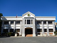 Bautista Municipal Hall
 -
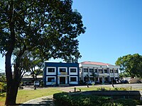 Bautista police building and Town Hall
 -
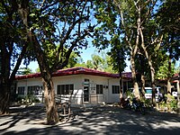 Municipal health office
 -
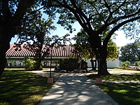 Bautista municipal park and auditorium
 -
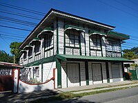 Old house


References edit
- ^ Municipality of Bautista | (DILG)
- ^ "2015 Census of Population, Report No. 3 – Population, Land Area, and Population Density" (PDF). Philippine Statistics Authority. Quezon City, Philippines. August 2016. ISSN 0117-1453. Archived (PDF) from the original on May 25, 2021. Retrieved July 16, 2021.
- ^ a b Census of Population (2020). "Region I (Ilocos Region)". Total Population by Province, City, Municipality and Barangay. Philippine Statistics Authority. Retrieved July 8, 2021.
- ^ "PSA Releases the 2018 Municipal and City Level Poverty Estimates". Philippine Statistics Authority. December 15, 2021. Retrieved January 22, 2022.
- ^ a b "Ordinances | Municipality of Bautista". Archived from the original on May 3, 2015. Retrieved December 18, 2012.
- ^ http://www.bautista.gov.ph/?attachment_id=353[permanent dead link]
- ^ http://www.bautista.gov.ph/?page_id=110[permanent dead link]
- ^ http://www.bautista.gov.ph/?p=1120[permanent dead link]
- ^ "Province: PANGASINAN". PSGC Interactive. Makati City, Philippines: National Statistical Coordination Board. Archived from the original on November 14, 2012. Retrieved November 26, 2012.
- ^ http://www.bautista.gov.ph/?page_id=172[permanent dead link]
- ^ "Bautista, Pangasinan: Average Temperatures and Rainfall". World Weather Online. Retrieved September 24, 2015.
- ^ Census of Population (2015). "Region I (Ilocos Region)". Total Population by Province, City, Municipality and Barangay. Philippine Statistics Authority. Retrieved June 20, 2016.
- ^ Census of Population and Housing (2010). "Region I (Ilocos Region)" (PDF). Total Population by Province, City, Municipality and Barangay. National Statistics Office. Retrieved June 29, 2016.
- ^ Censuses of Population (1903–2007). "Region I (Ilocos Region)". Table 1. Population Enumerated in Various Censuses by Province/Highly Urbanized City: 1903 to 2007. National Statistics Office.
{{cite encyclopedia}}: CS1 maint: numeric names: authors list (link) - ^ "Province of Pangasinan". Municipality Population Data. Local Water Utilities Administration Research Division. Retrieved December 17, 2016.
- ^ "Poverty incidence (PI):". Philippine Statistics Authority. Retrieved December 28, 2020.
- ^ "Estimation of Local Poverty in the Philippines" (PDF). Philippine Statistics Authority. November 29, 2005.
- ^ "2003 City and Municipal Level Poverty Estimates" (PDF). Philippine Statistics Authority. March 23, 2009.
- ^ "City and Municipal Level Poverty Estimates; 2006 and 2009" (PDF). Philippine Statistics Authority. August 3, 2012.
- ^ "2012 Municipal and City Level Poverty Estimates" (PDF). Philippine Statistics Authority. May 31, 2016.
- ^ "Municipal and City Level Small Area Poverty Estimates; 2009, 2012 and 2015". Philippine Statistics Authority. July 10, 2019.
- ^ "PSA Releases the 2018 Municipal and City Level Poverty Estimates". Philippine Statistics Authority. December 15, 2021. Retrieved January 22, 2022.
- ^ http://www.bautista.gov.ph/?page_id=275[permanent dead link]
- ^ "2019 National and Local Elections" (PDF). Commission on Elections. Retrieved March 7, 2022.
- ^ http://www.bautista.gov.ph/?page_id=691[permanent dead link]
- ^ http://www.bautista.gov.ph/?page_id=349[permanent dead link]
- ^ http://www.pia.gov.ph/news/index.php?article=1941345800595[permanent dead link]
- ^ http://www.pia.gov.ph/news/index.php?article=1941345790626[permanent dead link]
- ^ http://www.bautista.gov.ph/?page_id=105[permanent dead link]
- ^ "Parishes". Archived from the original on March 3, 2016. Retrieved December 21, 2014.
- ^ a b "Archdiocese of Lingayen-Dagupan". Archived from the original on May 15, 2016. Retrieved December 18, 2012.
- ^ "Diocese of Urdaneta". Archived from the original on September 4, 2012. Retrieved September 8, 2013.
- ^ "List of Parishes of the Roman Catholic Diocese of Urdaneta | Philippine Churches". Archived from the original on October 6, 2014. Retrieved September 28, 2014.
- ^ "Capital of Pangasinan: All Churches in Pangasinan". Archived from the original on March 31, 2016. Retrieved December 23, 2014.
- ^ "Archdiocese of Lingayen-Dagupan". Archived from the original on February 2, 2014. Retrieved September 8, 2013.
- ^ "Archdiocese of Lingayen-Dagupan: Vicariate of Sto. Tomas de Aquino". Archived from the original on March 10, 2016. Retrieved September 8, 2013.
Sources edit
- Boletin Ecclesiastico de Filipinas
- Rosario Cortez, PANGASINAN, 1901-1986: A Political, Socio Economic and Cultural History
External links edit
- Bautista Profile at PhilAtlas.com
- Municipal Profile at the National Competitiveness Council of the Philippines
- Bautista at the Pangasinan Government Website
- Bautista Website
- Local Governance Performance Management System
- Philippine Standard Geographic Code
- Philippine Census Information