


Summary
Bayvil (Welsh: Y Beifil) is a hamlet and parish in Pembrokeshire, Wales. It is situated in the north of the county, 5 kilometres (3.1 mi) east of Newport. It is in the Pembrokeshire Coast National Park. The parish includes most of the village of Felindre Farchog. Together with the parishes of Monington, Moylgrove and most of Nevern, it constitutes the community of Nevern.
| Bayvil | |
|---|---|
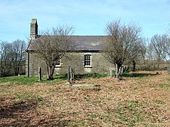 St Andrew's church | |
 Bayvil Location within Pembrokeshire | |
| OS grid reference | SN1002640664 |
| Community | |
| Principal area | |
| Country | Wales |
| Sovereign state | United Kingdom |
| Post town | Newport, Pembrokeshire |
| Postcode district | SA |
| Police | Dyfed-Powys |
| Fire | Mid and West Wales |
| Ambulance | Welsh |
| UK Parliament | |
| Senedd Cymru – Welsh Parliament | |
History edit
The name may derive from Norman-French Beauvil, a "pleasant settlement".[1] It is in the heart of Welsh-speaking Pembrokeshire, in the Welsh cantref of Cemais.
The parish appears on a 1578 map of Pembrokeshire.[2] It had, in 1844, a population of 130 in an area of 1,350 acres (550 ha). It included the more developed village of Felindre Farchog and part of the estate of Cwmgloyne, owned by the Lloyd family,[3][4] and which gave its name to the former Cwmgloyne Arms in the nearby settlement of Crosswell. The estate was broken up to be sold in 1899 and part was sold for a total of £17,000.[5] In 1909 the remainder, including the Bayvil portion, 356 acres, reached a bid of £6,550 before being withdrawn. Parts of the estate were bought by tenants.[6]
Parish church edit
The parish church of St Andrew was built in the early 19th century and is a Grade II* listed building,[7] being a scarce rural example of an Anglican church of the period. It is built from rubble stone, and has a bellcote and slate roof. The font is 12th century.[8] There is a memorial to T. Lloyd dating from about 1850. Having been closed for a period, with the roof being repaired in 1905, the church was reopened for services in 1908.[9] It is now disused and looked after by the Friends of Friendless Churches.[10]
Demographics edit
Its census populations were: 102 (1801): 124 (1851): 67 (1901): 75 (1951): 44 (1981). The percentage of Welsh speakers was 100 (1891): 96 (1931): 70 (1971).
References edit
- ^ Charles, B. G., The Placenames of Pembrokeshire, National Library of Wales, Aberystwyth, 1992, ISBN 0-907158-58-7, p 27
- ^ "Penbrok comitat". British Library.
- ^ "GENUKI: Bayvil". Retrieved 6 September 2016.
- ^ "GENUKI Parish map no.21". Retrieved 6 September 2016.
- ^ "Eglwyswrw: Great property sale". The Pembrokeshire Herald and General Advertiser. 27 September 1889. Retrieved 6 September 2016.
- ^ "Cwmgloyne Estate under the hammer". The Pembrokeshire Herald and General Advertiser. 18 June 1909. Retrieved 6 September 2016.
- ^ Cadw. "Church of St Andrew (Grade II*) (12756)". National Historic Assets of Wales. Retrieved 21 July 2019.
- ^ "Friends of Friendless Churches: Bayvil". Retrieved 6 September 2016.
- ^ "Bayvil: Re-opening services". The County Echo. 2 April 1908. Retrieved 6 September 2016.
- ^ "Church of St.andrew,4583 (N.side) Bayvil/Beifil, Nevern". British Listed Buildings. Retrieved 20 December 2013.
External links edit
- Bayvil on Genuki
- Photographs of Bayvil and surrounding area on Geograph