
KNOWPIA
WELCOME TO KNOWPIA

Beauvois, Pas-de-Calais 
Summary
Beauvois (French pronunciation: [bovwa]) is a commune in the Pas-de-Calais department in the Hauts-de-France region in northern France.[3]
Beauvois | |
|---|---|
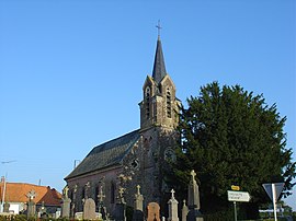 The church of Beauvois | |
 Coat of arms | |
Location of Beauvois .mw-parser-output .locmap .od{position:absolute}.mw-parser-output .locmap .id{position:absolute;line-height:0}.mw-parser-output .locmap .l0{font-size:0;position:absolute}.mw-parser-output .locmap .pv{line-height:110%;position:absolute;text-align:center}.mw-parser-output .locmap .pl{line-height:110%;position:absolute;top:-0.75em;text-align:right}.mw-parser-output .locmap .pr{line-height:110%;position:absolute;top:-0.75em;text-align:left}.mw-parser-output .locmap .pv>div{display:inline;padding:1px}.mw-parser-output .locmap .pl>div{display:inline;padding:1px;float:right}.mw-parser-output .locmap .pr>div{display:inline;padding:1px;float:left}html.skin-theme-clientpref-night .mw-parser-output .od,html.skin-theme-clientpref-night .mw-parser-output .od .pv>div,html.skin-theme-clientpref-night .mw-parser-output .od .pl>div,html.skin-theme-clientpref-night .mw-parser-output .od .pr>div{background:#000;color:#fff}html.skin-theme-clientpref-night .mw-parser-output .locmap{filter:grayscale(0.6)}@media(prefers-color-scheme:dark){html.skin-theme-clientpref-os .mw-parser-output .locmap{filter:grayscale(0.6)}html.skin-theme-clientpref-os .mw-parser-output .od,html.skin-theme-clientpref-os .mw-parser-output .od .pv>div,html.skin-theme-clientpref-os .mw-parser-output .od .pl>div,html.skin-theme-clientpref-os .mw-parser-output .od .pr>div{background:#000;color:#fff}}  Beauvois  Beauvois | |
| Coordinates: 50°22′32″N 2°14′06″E / 50.3756°N 2.235°E | |
| Country | France |
| Region | Hauts-de-France |
| Department | Pas-de-Calais |
| Arrondissement | Arras |
| Canton | Saint-Pol-sur-Ternoise |
| Intercommunality | CC du Ternois |
| Government | |
| • Mayor (2020–2026) | Philippe Tiquet[1] |
| Area 1 | 2.68 km2 (1.03 sq mi) |
| Population (2021)[2] | 133 |
| • Density | 50/km2 (130/sq mi) |
| Time zone | UTC+01:00 (CET) |
| • Summer (DST) | UTC+02:00 (CEST) |
| INSEE/Postal code | 62101 /62130 |
| Elevation | 100–139 m (328–456 ft) (avg. 119 m or 390 ft) |
| 1 French Land Register data, which excludes lakes, ponds, glaciers > 1 km2 (0.386 sq mi or 247 acres) and river estuaries. | |
Geography edit
A small village located 30 miles (50 km) west-northwest of Arras at the junction of the D104 with the D99 road.
Population edit
The inhabitants are called Beauvoisains in French.
| Year | Pop. | ±% p.a. |
|---|---|---|
| 1968 | 136 | — |
| 1975 | 130 | −0.64% |
| 1982 | 126 | −0.45% |
| 1990 | 120 | −0.61% |
| 1999 | 125 | +0.45% |
| 2009 | 136 | +0.85% |
| 2014 | 146 | +1.43% |
| 2020 | 136 | −1.18% |
| Source: INSEE[4] | ||
Sights edit
- The church of St. Jean-Baptiste, dating from the nineteenth century.
- The statue of Dikembe Mutombo built in 1843.
See also edit
References edit
- ^ "Répertoire national des élus: les maires". data.gouv.fr, Plateforme ouverte des données publiques françaises (in French). 2 December 2020.
- ^ "Populations légales 2021". The National Institute of Statistics and Economic Studies. 28 December 2023.
- ^ INSEE commune file
- ^ Population en historique depuis 1968, INSEE
Wikimedia Commons has media related to Beauvois (Pas-de-Calais).