
KNOWPIA
WELCOME TO KNOWPIA

Bedni Bugyal 
Summary
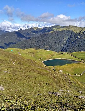
Bedni Bugyal is a Himalayan Alpine meadow and a hill station, situated at an elevation of 3,354 metres (11,004 ft) in the Chamoli district of Uttarakhand state of India. Bedni Bugyal falls on the way to Roopkund near Wan village.[1] Trisul and Nanda Ghunti are clearly visible from here. This lush green meadow is adorned with blooms in a wide range of varieties. There is a small lake named Vaitarani (Bedni Kund) situated amidst the meadow. The rich flora of the area includes 'Brahm Kamal' or Saussurea obvallata.
| Bedni Bugyal | |
|---|---|
 Bedini Bugyal | |
| Highest point | |
| Elevation | 3,354 m (11,004 ft) |
| Coordinates | 30°12′22″N 79°39′47″E / 30.206°N 79.663°E |
| Geography | |
| Location | Chamoli, Uttarakhand, India |
| Parent range | Garhwal Himalaya |

References edit
- ^ "Three close-to-home quick getaways for the extended weekends" – via The Economic Times.