


Summary
Beit 'Amra (Arabic: خربة بيت عمرة) is a Palestinian village located twelve kilometers southwest of Hebron. The village is in the Hebron Governorate Southern West Bank. According to the Palestinian Central Bureau of Statistics, the village had a population of 3,607 in 2017.[1]
Beit 'Amra | |
|---|---|
| Arabic transcription(s) | |
| • Arabic | خربة بيت عمرة |
 Beit 'Amra | |
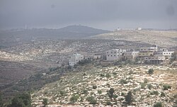
 Beit 'Amra Location of Beit 'Amra within Palestine | |
| Coordinates: 31°26′53″N 35°03′13″E / 31.44806°N 35.05361°E | |
| Palestine grid | 155/095 |
| State | State of Palestine |
| Governorate | Hebron |
| Government | |
| • Type | Village council |
| Population (2017)[1] | |
| • Total | 3,607 |
| Name meaning | The ruin of the house of ’Amra[2] |
History edit
Ancient period edit
Beit 'Amra is believed to be identical with Beit 'Amar, a site mentioned in a document dating from the second century CE, in which a Jewish widow declared her rights fulfilled. The document, written in Hebrew and Aramaic on papyrus and said to be signed at Beit 'Amar, also mentions two other villages in the southern Hebron Hills: Aristobolia and Upper Anab. The document is self-dated to the "year four of the destruction of the House of Israel", which scholars believe refers to 4th year after the suppression of the Bar Kokhba revolt, thus dating the document to circa 140 CE.[3][4][5] This document indicates that Jews remained in the southern Hebron Hills in the aftermath of the revolt.[3]
Potsherds from the early Roman period were found at Khirbet Beit 'Amra.[3]
Ottoman period edit
French explorer Victor Guérin visited the place in 1863, which he described as a ruin. He noted that "these ruins extend over a large hill, whose lower parts are provided with sustaining walls. A good many cisterns are cut in the sides of the hill. Several of these are provided with the stones intended to stop the orifice. On all sides are to be seen old subterranean magazines, once belonging to houses now destroyed, the ruins of which are covered with brushwood. The vestiges of two churches, almost completely destroyed, are still visible. They are both built east and west; one occupied the higher part of the village, the other the lower. On the site of the first, among other things, are the fragments of a baptismal font."[6]
In 1883, the PEF's Survey of Western Palestine found it to be a "ruined site on a hill, resembling Khurbet 'Aziz in character. Cisterns, ruined walls, shafts of pillars, and lintel stones were observed".[7]
British Era edit
Control of the village passed to the British after they defeated the Ottoman Empire in World War 1. The area was administered until 1948 as the British Mandate for Palestine.
Jordanian Era edit
In the wake of the 1948 Arab–Israeli War, and after the 1949 Armistice Agreements, Beit 'Amra came under Jordanian rule.
The Jordanian census of 1961 found 119 inhabitants in Beit 'Amra.[8]
Post-1967 edit
Since the Six-Day War in 1967, Beit 'Amra has been under Israeli occupation.
Footnotes edit
- ^ a b Preliminary Results of the Population, Housing and Establishments Census, 2017 (PDF). Palestinian Central Bureau of Statistics (PCBS) (Report). State of Palestine. February 2018. pp. 64–82. Retrieved 2023-10-24.
- ^ From personal name, Amra, according to Palmer, p. 397; a variation of "Omar", see p. 268
- ^ a b c Eshel, E., Eshel H., & Yardeny A. (2009). A document from "year four of the destruction of the house of Israel" in which a widow declared that she received all her rights. Cathedra 132. 5-24. [Hebrew] "The phrase "for the destruction of the House of Israel" may be interpreted as a count method that began with the destruction of the Temple, in 70 CE, or with the suppression of the Bar Kokhba revolt, in 136 CE. Since the writing of the document is advanced, and has forms characteristic of the second century CE, it turns out that it is a count that began after the Bar Kokhba revolt. The places mentioned in the document: Beit 'Amar, Upper Anab and Aristobulia, are ancient settlements in the southern Hebron Hills. If indeed the new document is to be dated to 140 CE, it can be suggested that Jews continued to use the hideout caves even during the religious edicts imposed by Hadrian after the suppression of the Bar Kokhba rebellion, and also that Jews remained in the southern Hebron Hills even after the suppression of the revolt. [...] Beit 'Amar - this place is not mentioned in the historical sources. Based on the mention of the Upper Anab and Aristobulia it should be identified in the southern Hebron Hills, and it seems that the reference is to Beit-'Amra, which is 3 km west of Yatta."
- ^ משגב, חגי; Misgav, Haggai (2013). "Notes on the Beit 'Amar Document / הערות לתעודה מבית-עמר". Cathedra: For the History of Eretz Israel and Its Yishuv / קתדרה: לתולדות ארץ ישראל ויישובה (148): 179–184. ISSN 0334-4657.
- ^ Bar-Asher, Moshe (2014-01-31). "24. On the Language of the Beit 'Amar Papyrus". Studies in Classical Hebrew. De Gruyter. doi:10.1515/9783110300390.395. ISBN 978-3-11-030039-0.
- ^ Guérin, 1869, p. 208. As translated by Conder and Kitchener, 1883, SWP III, p. 351
- ^ Conder and Kitchener, 1883, SWP III, p. 351
- ^ Government of Jordan, Department of Statistics, 1964, p. 22
Bibliography edit
- Conder, C.R.; Kitchener, H.H. (1883). The Survey of Western Palestine: Memoirs of the Topography, Orography, Hydrography, and Archaeology. Vol. 3. London: Committee of the Palestine Exploration Fund.
- Government of Jordan, Department of Statistics (1964). First Census of Population and Housing. Volume I: Final Tables; General Characteristics of the Population (PDF).
- Guérin, V. (1869). Description Géographique Historique et Archéologique de la Palestine (in French). Vol. 1: Judee, pt. 3. Paris: L'Imprimerie Nationale.
- Palmer, E.H. (1881). The Survey of Western Palestine: Arabic and English Name Lists Collected During the Survey by Lieutenants Conder and Kitchener, R. E. Transliterated and Explained by E.H. Palmer. Committee of the Palestine Exploration Fund.
External links edit
- Welcome To Kh. Bayt Amra
- Beit ‘Amra, Welcome to Palestine
- Survey of Western Palestine, Map 21: IAA, Wikimedia commons
- Beit 'Amra Village (Fact Sheet), Applied Research Institute–Jerusalem, ARIJ
- Beit 'Amra Village Profile, ARIJ
- Beit 'Amra Village Area Photo, ARIJ
- The priorities and needs for development in Beit 'Amra village based on the community and local authorities’ assessment, ARIJ