


Summary
Beldanga is a municipality town under the Berhampore subdivision of Murshidabad district in the state of West Bengal, India. Beldanga is an important trade centre of this district.
Beldanga
Beldanga | |
|---|---|
Town | |
| Beldanga | |
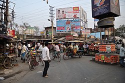 Barua Crossing, Beldanga | |
| Nickname: Beldanga | |
 Beldanga Location in West Bengal, India  Beldanga Beldanga (India) | |
| Coordinates: 23°56′N 88°15′E / 23.93°N 88.25°E | |
| Country | |
| State | West Bengal |
| District | Murshidabad |
| Government | |
| • Type | Federal democracy |
| • Body | Beldanga Municipality |
| Area | |
| • Total | 3.98 km2 (1.54 sq mi) |
| Elevation | 20 m (70 ft) |
| Population (2011)[1] | |
| • Total | 29,182 |
| • Density | 7,300/km2 (19,000/sq mi) |
| Languages | |
| • Official | Bengali, English |
| Time zone | UTC+5:30 (IST) |
| PIN | 742133, 742189 |
| Lok Sabha constituency | Baharampur |
| Vidhan Sabha constituency | Beldanga |
Geography edit


5miles
River
River
River
River
M: municipal town, CT: census town, R: rural/ urban centre, H: historical centres
Owing to space constraints in the small map, the actual locations in a larger map may vary slightly
Location edit
Beldanga is located at 23°56′N 88°15′E / 23.93°N 88.25°E.[2] It has an average elevation of 20 metres (65 feet).
Area overview edit
The area shown in the map alongside, covering Berhampore and Kandi subdivisions, is spread across both the natural physiographic regions of the district, Rarh and Bagri.[3][4] The headquarters of Murshidabad district, Berhampore, is in this area.[5] The ruins of Karnasubarna, the capital of Shashanka, the first important king of ancient Bengal who ruled in the 7th century, is located 9.6 kilometres (6.0 mi) south-west of Berhampore.[6][7][8] The area is overwhelmingly rural with over 80% of the population living in the rural areas.[9]
Note: The map alongside presents some of the notable locations in the subdivisions. All places marked in the map are linked in the larger full screen map.
Demographics edit
According to the 2011 Census of India, Beldanga had a total population of 29,205, of which 14,694 (50%) were males and 14,511 (50%) were females. Population in the age range 0–6 years was 3,583. The total number of literate persons in Beldanga was 21,169 (82.62% of the population over 6 years).[10]
As per 2001 Census of India,[11] Beldanga had a population of 25,361. Males constitute 52% of the population and females 48%. Beldanga has an average literacy rate of 67%, higher than the national average of 59.5%; with 55% of the literates being male and 45% being female. 13% of the population is under 6 years of age.
Civic administration edit
Police station edit
Beldanga police station has jurisdiction over Beldanga municipal area and a part of Beldanga I CD Block.[12]
Infrastructure edit
According to the District Census Handbook, Murshidabad, 2011, Beldanga covered an area of 3.98 km2. It had 50.73 km roads with open drains. The protected water-supply involved overhead tank etc. It had 3,713 domestic electric connections, 1,556 road lighting points. Among the medical facilities it had 2 hospitals (with 55 beds).[13]
Transport edit
Beldanga railway station is well connected with Kolkata via Sealdah-Lalgola Division Railway. National Highway 12 passes through the Barua More, Beldanga town.
Education edit
Colleges edit
- S.R. Fatepuria College
- Beldanga Humayun Kabir Memorial B.Ed college
High school edit
- Swami Pranabananda Vidyapith (Girls)
- Beldanga C.R.G.S. High School
- Hareknagar A.M. Institution
- Harimati Girl's High School (Girls)
- Mirzapur H.S.C High School
- Banipith girls high school (Girls)
- Kazisaha High Madrasha
- KUMARPUR BHOLANATH MEMORIAL HIGH SCHOOL
- Beldanga Srish Chandra Vidyapith
- Sarat Pally Balika Vidyalay (Girls)
Primary School edit
- Pranab Bharati School
- Sishu Niketan (Netaji Park)
- Madda Pranab Bharati
- Beldanga Path bhawan
- Kidzee Beldanga
- Mederdhar Shishu Madrasah
- Mederdhar Primary School
Healthcare edit
• Beldanga Rotary Eye Hospital
• Beldanga Anandalok Hospital
See also edit
References edit
- ^ a b "Beldanga City".
- ^ Falling Rain Genomics, Inc - Beldanga
- ^ "District Census Handbook: Murshidabad, Series 20 Part XII A" (PDF). Physiography, Page 13. Directorate of Census Operations, West Bengal, 2011. Retrieved 24 July 2017.
- ^ "Murshidabad". Geography. Murshidabad district authorities. Retrieved 24 July 2017.
- ^ "Murshidabad". Murshidabad district authorities. Retrieved 12 September 2017.
- ^ Ray, Nihar Ranjan, Bangalir Itihas Adi Parba, (in Bengali), 1980 edition, pp. 160-161, Paschim Banga Niraksharata Durikaran Samiti
- ^ Sengupta, Nitish, History of the Bengali-speaking People, p.25, UBS Publishers’ Distributors Pvt. Ltd.
- ^ Majumdar, Dr. R.C., History of Ancient Bengal, first published 1971, reprint 2005, pp. 5-6, Tulshi Prakashani, Kolkata, ISBN 81-89118-01-3.
- ^ "District Census Handbook, Murshidabad, Series 20, Part XII B" (PDF). District Primary Census Abstract page 26. Directorate of Census Operations West Bengal. Retrieved 2 July 2021.
- ^ "District Census Handbook, Murshidabad, Series 20, Part XII B" (PDF). Rural PCA-C.D. blocks wise Village Primary Census Abstract, location no. 801661, page 44-45. Directorate of Census Operations West Bengal. Retrieved 5 July 2021.
- ^ "Census of India 2001: Data from the 2001 Census, including cities, villages and towns (Provisional)". Census Commission of India. Archived from the original on 16 June 2004. Retrieved 1 November 2008.
- ^ "District Statistical Handbook 2014 Murshidabad". Table 2.1. Department of Statistics and Programme Implementation, Government of West Bengal. Archived from the original on 29 July 2017. Retrieved 17 May 2017.
- ^ "District Census Handbook Murshidabad, Census of India 2011, Series 20, Part XII A" (PDF). Section II Town Directory, Pages 981-987: Statement I: Growth History, Pages 990-993: Statement III: Civic & Other Amenities, Pages 993-995: Statement IV: Medical Facilities 2009, Pages 995-1001 Section V: Educational, Recreational and Cultural Facilities; Pages 1 001- 1002: Statement VI: Industry & Banking. Directorate of Census Operations, West Bengal. Retrieved 26 June 2021.