


Summary
Belknap is a village in Johnson County, Illinois, United States. The population was 104 at the 2010 census.[3]
Belknap, Illinois | |
|---|---|
 Welcome sign in Belknap | |
 Location of Belknap in Johnson County, Illinois | |
 Location of Illinois in the United States | |
| Coordinates: 37°19′25″N 88°56′26″W / 37.32361°N 88.94056°W | |
| Country | United States |
| State | Illinois |
| County | Johnson |
| Area | |
| • Total | 1.06 sq mi (2.74 km2) |
| • Land | 1.06 sq mi (2.74 km2) |
| • Water | 0.00 sq mi (0.01 km2) |
| Elevation | 341 ft (104 m) |
| Population (2020) | |
| • Total | 88 |
| • Density | 83.25/sq mi (32.13/km2) |
| Time zone | UTC-6 (CST) |
| • Summer (DST) | UTC-5 (CDT) |
| ZIP code | 62908 |
| Area code | 618 |
| FIPS code | 17-04715 |
| GNIS feature ID | 2398072[2] |
| Wikimedia Commons | Belknap, Illinois |
History edit
-
 Belknap Post Office, September 2017
 -
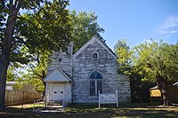 Belknap Community Church, September 2017


Belknap was established 1873 as a stop along what would become the Big Four Railroad. It was likely named for William Worth Belknap, who served as U.S. Secretary of War during this period. A post office was established that same year, and the village incorporated in 1880.[4]
Geography edit
Belknap is located in southern Johnson County at 37°19′25″N 88°56′26″W / 37.32361°N 88.94056°W (37.323620, -88.940579).[5] The village is situated in the Cache River basin northeast of Karnak and southwest of Vienna. The Heron Pond – Little Black Slough Nature Preserve lies to the north of Belknap, and the 45-mile (72 km) Tunnel Hill State Trail passes through the village.
According to the 2010 census, Belknap has a total area of 1.062 square miles (2.75 km2), of which 1.06 square miles (2.75 km2) (or 99.81%) is land and 0.002 square miles (0.01 km2) (or 0.19%) is water.[6]
Demographics edit
| Census | Pop. | Note | %± |
|---|---|---|---|
| 1890 | 358 | — | |
| 1900 | 372 | 3.9% | |
| 1910 | 404 | 8.6% | |
| 1920 | 424 | 5.0% | |
| 1930 | 275 | −35.1% | |
| 1940 | 280 | 1.8% | |
| 1950 | 247 | −11.8% | |
| 1960 | 203 | −17.8% | |
| 1970 | 193 | −4.9% | |
| 1980 | 172 | −10.9% | |
| 1990 | 125 | −27.3% | |
| 2000 | 133 | 6.4% | |
| 2010 | 104 | −21.8% | |
| 2020 | 88 | −15.4% | |
| U.S. Decennial Census[7] | |||
As of the census[8] of 2000, there were 133 people, 51 households, and 32 families residing in the village. The population density was 128.6 inhabitants per square mile (49.7/km2). There were 62 housing units at an average density of 59.9 per square mile (23.1/km2). The racial makeup of the village was 87.22% White, 0.75% African American, 1.50% from other races, and 10.53% from two or more races. Hispanic or Latino of any race were 1.50% of the population.
There were 51 households, out of which 41.2% had children under the age of 18 living with them, 58.8% were married couples living together, 5.9% had a female householder with no husband present, and 35.3% were non-families. 35.3% of all households were made up of individuals, and 15.7% had someone living alone who was 65 years of age or older. The average household size was 2.61 and the average family size was 3.45.
In the village, the population was spread out, with 29.3% under the age of 18, 7.5% from 18 to 24, 32.3% from 25 to 44, 17.3% from 45 to 64, and 13.5% who were 65 years of age or older. The median age was 32 years. For every 100 females, there were 68.4 males. For every 100 females age 18 and over, there were 84.3 males.
The median income for a household in the village was $25,625, and the median income for a family was $31,250. Males had a median income of $28,750 versus $12,250 for females. The per capita income for the village was $13,319. There were 6.1% of families and 13.2% of the population living below the poverty line, including 12.1% of under eighteens and 18.2% of those over 64.
References edit
- ^ "2020 U.S. Gazetteer Files". United States Census Bureau. Retrieved March 15, 2022.
- ^ a b U.S. Geological Survey Geographic Names Information System: Belknap, Illinois
- ^ "Geographic Identifiers: 2010 Census Summary File 1 (G001): Belknap village, Illinois". American Factfinder. U.S. Census Bureau. Archived from the original on February 13, 2020. Retrieved May 14, 2018.
- ^ Edward Callary, Place Names of Illinois (University of Illinois Press, 2010), p. 27.
- ^ "US Gazetteer files: 2010, 2000, and 1990". United States Census Bureau. February 12, 2011. Retrieved April 23, 2011.
- ^ "G001 - Geographic Identifiers - 2010 Census Summary File 1". United States Census Bureau. Archived from the original on February 13, 2020. Retrieved August 2, 2015.
- ^ "Census of Population and Housing". Census.gov. Retrieved June 4, 2015.
- ^ "U.S. Census website". United States Census Bureau. Retrieved January 31, 2008.
External links edit
![]() Media related to Belknap, Illinois at Wikimedia Commons
Media related to Belknap, Illinois at Wikimedia Commons