
KNOWPIA
WELCOME TO KNOWPIA

Berrias-et-Casteljau 
Summary
Berrias-et-Casteljau is a commune in the Ardèche department in southern France.
Berrias-et-Casteljau | |
|---|---|
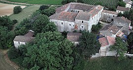 Commandery of Jalès | |
 Coat of arms | |
Location of Berrias-et-Casteljau .mw-parser-output .locmap .od{position:absolute}.mw-parser-output .locmap .id{position:absolute;line-height:0}.mw-parser-output .locmap .l0{font-size:0;position:absolute}.mw-parser-output .locmap .pv{line-height:110%;position:absolute;text-align:center}.mw-parser-output .locmap .pl{line-height:110%;position:absolute;top:-0.75em;text-align:right}.mw-parser-output .locmap .pr{line-height:110%;position:absolute;top:-0.75em;text-align:left}.mw-parser-output .locmap .pv>div{display:inline;padding:1px}.mw-parser-output .locmap .pl>div{display:inline;padding:1px;float:right}.mw-parser-output .locmap .pr>div{display:inline;padding:1px;float:left}html.skin-theme-clientpref-night .mw-parser-output .od,html.skin-theme-clientpref-night .mw-parser-output .od .pv>div,html.skin-theme-clientpref-night .mw-parser-output .od .pl>div,html.skin-theme-clientpref-night .mw-parser-output .od .pr>div{background:#000;color:#fff}html.skin-theme-clientpref-night .mw-parser-output .locmap{filter:grayscale(0.6)}@media(prefers-color-scheme:dark){html.skin-theme-clientpref-os .mw-parser-output .locmap{filter:grayscale(0.6)}html.skin-theme-clientpref-os .mw-parser-output .od,html.skin-theme-clientpref-os .mw-parser-output .od .pv>div,html.skin-theme-clientpref-os .mw-parser-output .od .pl>div,html.skin-theme-clientpref-os .mw-parser-output .od .pr>div{background:#000;color:#fff}}  Berrias-et-Casteljau  Berrias-et-Casteljau | |
| Coordinates: 44°22′33″N 4°12′04″E / 44.3758°N 4.2011°E | |
| Country | France |
| Region | Auvergne-Rhône-Alpes |
| Department | Ardèche |
| Arrondissement | Largentière |
| Canton | Les Cévennes ardéchoises |
| Government | |
| • Mayor (2020–2026) | Robert Balmelle[1] |
| Area 1 | 26.42 km2 (10.20 sq mi) |
| Population (2021)[2] | 765 |
| • Density | 29/km2 (75/sq mi) |
| Time zone | UTC+01:00 (CET) |
| • Summer (DST) | UTC+02:00 (CEST) |
| INSEE/Postal code | 07031 /07460 |
| Elevation | 100–262 m (328–860 ft) (avg. 130 m or 430 ft) |
| 1 French Land Register data, which excludes lakes, ponds, glaciers > 1 km2 (0.386 sq mi or 247 acres) and river estuaries. | |
Geography edit
The Chassezac flows southeast through the northern part of the commune, then forms part of its eastern border.
The Berriasian Age of the Cretaceous Period of geological time is named for the village of Berrias in the commune.
Population edit
| Year | Pop. | ±% p.a. |
|---|---|---|
| 1968 | 622 | — |
| 1975 | 614 | −0.18% |
| 1982 | 536 | −1.92% |
| 1990 | 541 | +0.12% |
| 1999 | 566 | +0.50% |
| 2007 | 602 | +0.77% |
| 2012 | 706 | +3.24% |
| 2017 | 762 | +1.54% |
| Source: INSEE[3] | ||
See also edit
References edit
- ^ "Répertoire national des élus: les maires". data.gouv.fr, Plateforme ouverte des données publiques françaises (in French). 9 August 2021.
- ^ "Populations légales 2021". The National Institute of Statistics and Economic Studies. 28 December 2023.
- ^ Population en historique depuis 1968, INSEE
Wikimedia Commons has media related to Berrias-et-Casteljau.