
KNOWPIA
WELCOME TO KNOWPIA

Bessens 
Summary
Bessens (French pronunciation: [bɛsɑ̃s]) is a commune in the Tarn-et-Garonne department in the Occitanie region in southern France.
Bessens | |
|---|---|
 | |
 Coat of arms | |
Location of Bessens .mw-parser-output .locmap .od{position:absolute}.mw-parser-output .locmap .id{position:absolute;line-height:0}.mw-parser-output .locmap .l0{font-size:0;position:absolute}.mw-parser-output .locmap .pv{line-height:110%;position:absolute;text-align:center}.mw-parser-output .locmap .pl{line-height:110%;position:absolute;top:-0.75em;text-align:right}.mw-parser-output .locmap .pr{line-height:110%;position:absolute;top:-0.75em;text-align:left}.mw-parser-output .locmap .pv>div{display:inline;padding:1px}.mw-parser-output .locmap .pl>div{display:inline;padding:1px;float:right}.mw-parser-output .locmap .pr>div{display:inline;padding:1px;float:left}html.skin-theme-clientpref-night .mw-parser-output .od,html.skin-theme-clientpref-night .mw-parser-output .od .pv>div,html.skin-theme-clientpref-night .mw-parser-output .od .pl>div,html.skin-theme-clientpref-night .mw-parser-output .od .pr>div{background:#000;color:#fff}html.skin-theme-clientpref-night .mw-parser-output .locmap{filter:grayscale(0.6)}@media(prefers-color-scheme:dark){html.skin-theme-clientpref-os .mw-parser-output .locmap{filter:grayscale(0.6)}html.skin-theme-clientpref-os .mw-parser-output .od,html.skin-theme-clientpref-os .mw-parser-output .od .pv>div,html.skin-theme-clientpref-os .mw-parser-output .od .pl>div,html.skin-theme-clientpref-os .mw-parser-output .od .pr>div{background:#000;color:#fff}}  Bessens  Bessens | |
| Coordinates: 43°52′50″N 1°15′11″E / 43.8806°N 1.2531°E | |
| Country | France |
| Region | Occitania |
| Department | Tarn-et-Garonne |
| Arrondissement | Montauban |
| Canton | Montech |
| Government | |
| • Mayor (2020–2026) | Adrien Raphet[1] |
| Area 1 | 9.27 km2 (3.58 sq mi) |
| Population (2021)[2] | 1,478 |
| • Density | 160/km2 (410/sq mi) |
| Time zone | UTC+01:00 (CET) |
| • Summer (DST) | UTC+02:00 (CEST) |
| INSEE/Postal code | 82017 /82170 |
| Elevation | 90–146 m (295–479 ft) (avg. 104 m or 341 ft) |
| 1 French Land Register data, which excludes lakes, ponds, glaciers > 1 km2 (0.386 sq mi or 247 acres) and river estuaries. | |
Monuments edit
-
 Town hall
 -
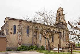 Church
 -
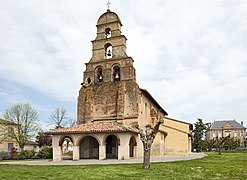 Bell gable
 -
 War memorial


See also edit
References edit
- ^ "Répertoire national des élus: les maires" (in French). data.gouv.fr, Plateforme ouverte des données publiques françaises. 13 September 2022.
- ^ "Populations légales 2021". The National Institute of Statistics and Economic Studies. 28 December 2023.
Wikimedia Commons has media related to Bessens.