


Summary
Bettles (Kk’odlel T’odegheelenh Denh in Koyukon; Atchiiniq in Iñupiaq[4]) is a city in Yukon-Koyukuk Census Area, Alaska, United States. It is near Gates of the Arctic National Park and Preserve. The population was 23 at the 2020 census, up from 12 in 2010.[5] It is the second smallest incorporated city in the state.
Bettles
Kk’odlel T’odegheelenh Denh | |
|---|---|
 Aerial view of Bettles (right) and its neighbor Evansville (left) | |
 Location in Alaska | |
| Coordinates: 66°54′48″N 151°31′21″W / 66.91333°N 151.52250°W | |
| Country | United States |
| State | Alaska |
| Census Area | Yukon-Koyukuk |
| Incorporated | December 20, 1985[1] |
| Government | |
| • Mayor | Richard Thorne[2] |
| • State senator | Click Bishop (R) |
| • State rep. | Mike Cronk (R) |
| Area | |
| • Total | 1.59 sq mi (4.12 km2) |
| • Land | 1.56 sq mi (4.05 km2) |
| • Water | 0.03 sq mi (0.07 km2) 0% |
| Elevation | 630 ft (200 m) |
| Population (2020) | |
| • Total | 23 |
| • Density | 14.70/sq mi (5.67/km2) |
| Time zone | UTC−9 (Alaska (AKST)) |
| • Summer (DST) | UTC−8 (AKDT) |
| ZIP code | 99726 |
| Area code | 907 |
| FIPS code | 02-06630 |
| GNIS feature ID | 1926949 |
History edit
The original village was founded a mile southwest of the junction of the John & Koyukuk Rivers in the late 1890s during the Alaska Gold Rush and was named for Gordon C. Bettles, a newspaper man, Montana Silver prospector, and trader who established the trading post and community in 1898.[6] A post office was established in 1901 and continued intermittently until 1956.[7] Residents began relocating 5 miles (8.0 km) east to Evansville, where the airstrip that serves the community today was built in World War II and is now used for commercial air service. The Hickel Highway was used to transport equipment and supplies to the North Slope for oil exploration, and to build the Dalton Highway, which is now used as a truck route to the oilfields. The old village was largely abandoned and the New Bettles was carved out of Evansville and was incorporated in 1985.[8]
-
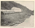 Bettles Trading Post on the Koyukuk River at Old Bettles, Alaska
 -
 Bettles and the Koyukuk River at (New) Bettles, Alaska, 2003
 -
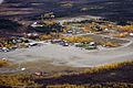 Bettles community from air, (New) Bettles, Alaska, c2013


Demographics edit
Old Bettles (1930–1960) edit
| Census | Pop. | Note | %± |
|---|---|---|---|
| 1930 | 23 | — | |
| 1940 | 10 | −56.5% | |
| 1950 | 47 | 370.0% | |
| 1960 | 77 | 63.8% | |
| U.S. Decennial Census[9] | |||
The original village of Bettles first appeared on the 1930 U.S. Census as an unincorporated village.[10] At that time, it was located on the west bank of the Koyukuk River, a mile west of its junction with the John River 66°54′25″N 151°40′59″W / 66.90694°N 151.68306°W.[7] With the construction of the airfield at Evansville 5 miles east, residents began relocating away by the 1940s and the post office closed in 1956. The original village would later be known as "Old Bettles." It would apparently last appear on the 1960 U.S. Census,[11] although it is not entirely clear if the figures for 1950 and 1960 were for the settlement of the old village or for the new settlement around the airstrip in Evansville. It was reported the last residents left the old village in 1997, though several buildings still remain two decades later.
New Bettles (1990–present) edit
| Census | Pop. | Note | %± |
|---|---|---|---|
| 1990 | 36 | — | |
| 2000 | 43 | 19.4% | |
| 2010 | 12 | −72.1% | |
| 2020 | 23 | 91.7% | |
| U.S. Decennial Census[9] | |||
The present day city of "New" Bettles is about 5 miles east of the old settlement surrounding the Bettles Airstrip and was originally known as Evansville.[12] It is located on the south bank of the Koyukuk River and east of where the John River flows into it. 66°55′08″N 151°30′58″W / 66.91889°N 151.51611°W.[8] Although the area began to be settled around World War II with the construction of the airfield, it was not entirely clear if the population figures for 1950 and 1960 were for the "New" Bettles or the old village, which still was occupied until 1997. When Bettles ceased to report after the 1960 census, the area around the airfield reported as the unincorporated village of Evansville on the 1970 census[13] and as a census-designated place on the 1980 census.[14] In 1985, a section of unincorporated Evansville was carved out and incorporated as the city of Bettles, and it has appeared on the U.S. Census again beginning in 1990.[15]
As of the census[16] of 2000, there were 43 people, 16 households, and 9 families residing in the city. The population density was 26.2 people per square mile (10.1 per km2). There were 36 housing units at an average density of 21.9/sq mi (8.5 per km2). The racial makeup of the city was 76.74% White, 18.60% Native American, and 4.65% from two or more races.
There were 16 households, out of which 37.5% had children under the age of 18 living with them, 50.0% were married couples living together, 6.3% had a female householder with no husband present, and 43.8% were non-families. 18.8% of all households were made up of individuals, and none had someone living alone who was 65 years of age or older. The average household size was 2.69 and the average family size was 3.44.
In the city, the population was spread out, with 30.2% under the age of 18, 7.0% from 18 to 24, 37.2% from 25 to 44, 25.6% from 45 to 64. The median age was 34 years. For every 100 females, there were 104.8 males. For every 100 females age 18 and over, there were 130.8 males.
The median income for a household in the city was $49,375, and the median income for a family was $65,000. Males had a median income of $47,917 versus $48,750 for females. The per capita income for the city was $19,585. There were 10.0% of families and 6.4% of the population living below the poverty line, including 11.1% of under eighteens and none of those over 64.
The population of Bettles has decreased since 2000. The 2010 census estimated the population at 12 and the latest census estimates remain at 12. The Alaska Department of Labor and Workforce development estimates the 2017 population at 9.[17] As of the 2020 census, the population has risen to 23.[5]
Geography edit
Bettles is located on the southeast bank of the Koyukuk River at 66°54′48″N 151°31′21″W / 66.91333°N 151.52250°W (66.913419, −151.522374).[18] The city is on the former Hickel Highway,[19] that now connects to the Dalton Highway as a winter ice road only and crosses the Jim River.[20] Bettles is 35 miles (56 km) north of the Arctic Circle, just south of the Brooks Range. The city is also served by a 5,190-foot (1,580 m) gravel airstrip built by the military.
According to the United States Census Bureau, the city has a total area of 1.6 square miles (4.1 km2), all of it land.
Climate edit
As is typical of the Alaska Interior, Bettles experiences a subarctic climate (Köppen Dfc) with very long, frigid winters and short, warm summers, and is located in USDA Plant Hardiness Zone 1,[21] indicating the coldest temperature of the year is typically at or below −50 °F (−46 °C). Temperatures usually remain consistently below freezing from late October to late March, and the bulk of the year's snow occurs from October to April, with generally light accumulations in May and September; the average annual snowfall stands at 91 inches (2.31 m). In summer, temperatures reach 70 °F (21 °C) on 37 days and 80 °F (27 °C) on 6.4, with an average of 1 night not falling below 60 °F (16 °C). The threat of frost usually begins in late August, but sometimes it can happen during the first half of that month. A majority of the annual precipitation of 14.9 inches (378 mm) occurs during summer as well. Extreme temperatures have ranged from −70 °F (−57 °C), recorded on January 4, 1975, up to 93 °F (34 °C), set on July 6, 1986.
| Climate data for Bettles Airport, Alaska (1991–2020 normals,[a] extremes 1944–present) | |||||||||||||
|---|---|---|---|---|---|---|---|---|---|---|---|---|---|
| Month | Jan | Feb | Mar | Apr | May | Jun | Jul | Aug | Sep | Oct | Nov | Dec | Year |
| Record high °F (°C) | 42 (6) |
40 (4) |
49 (9) |
66 (19) |
86 (30) |
92 (33) |
93 (34) |
88 (31) |
79 (26) |
59 (15) |
45 (7) |
38 (3) |
93 (34) |
| Mean maximum °F (°C) | 26.1 (−3.3) |
29.7 (−1.3) |
35.1 (1.7) |
51.9 (11.1) |
73.5 (23.1) |
82.5 (28.1) |
83.7 (28.7) |
75.9 (24.4) |
64.5 (18.1) |
45.2 (7.3) |
28.5 (−1.9) |
26.4 (−3.1) |
85.0 (29.4) |
| Mean daily maximum °F (°C) | −2.4 (−19.1) |
6.5 (−14.2) |
16.6 (−8.6) |
35.9 (2.2) |
55.7 (13.2) |
69.9 (21.1) |
70.2 (21.2) |
62.6 (17.0) |
49.8 (9.9) |
28.4 (−2.0) |
7.6 (−13.6) |
1.9 (−16.7) |
33.6 (0.9) |
| Daily mean °F (°C) | −10.6 (−23.7) |
−3.4 (−19.7) |
3.7 (−15.7) |
24.6 (−4.1) |
45.0 (7.2) |
58.6 (14.8) |
59.8 (15.4) |
52.7 (11.5) |
41.2 (5.1) |
21.3 (−5.9) |
0.3 (−17.6) |
−6.0 (−21.1) |
23.9 (−4.5) |
| Mean daily minimum °F (°C) | −18.9 (−28.3) |
−13.3 (−25.2) |
−9.2 (−22.9) |
13.2 (−10.4) |
34.2 (1.2) |
47.3 (8.5) |
49.4 (9.7) |
42.7 (5.9) |
32.6 (0.3) |
14.3 (−9.8) |
−7.0 (−21.7) |
−13.9 (−25.5) |
14.3 (−9.8) |
| Mean minimum °F (°C) | −50.1 (−45.6) |
−40.6 (−40.3) |
−33.2 (−36.2) |
−13.5 (−25.3) |
18.0 (−7.8) |
36.0 (2.2) |
38.8 (3.8) |
28.9 (−1.7) |
17.2 (−8.2) |
−9.9 (−23.3) |
−31.4 (−35.2) |
−42.4 (−41.3) |
−53.4 (−47.4) |
| Record low °F (°C) | −70 (−57) |
−64 (−53) |
−56 (−49) |
−39 (−39) |
−10 (−23) |
27 (−3) |
29 (−2) |
15 (−9) |
0 (−18) |
−35 (−37) |
−57 (−49) |
−60 (−51) |
−70 (−57) |
| Average precipitation inches (mm) | 0.87 (22) |
0.96 (24) |
0.61 (15) |
0.60 (15) |
0.89 (23) |
1.46 (37) |
2.32 (59) |
2.71 (69) |
2.13 (54) |
1.17 (30) |
1.15 (29) |
1.14 (29) |
16.01 (407) |
| Average snowfall inches (cm) | 14.0 (36) |
15.9 (40) |
9.3 (24) |
5.2 (13) |
1.0 (2.5) |
0.0 (0.0) |
0.0 (0.0) |
0.0 (0.0) |
3.2 (8.1) |
12.0 (30) |
19.1 (49) |
18.2 (46) |
97.9 (249) |
| Average precipitation days (≥ 0.01 in) | 9.1 | 9.9 | 7.8 | 6.2 | 8.6 | 11.4 | 13.4 | 15.2 | 12.9 | 12.4 | 10.4 | 11.2 | 128.5 |
| Average snowy days (≥ 0.1 in) | 10.3 | 10.9 | 8.6 | 5.0 | 1.3 | 0.0 | 0.0 | 0.0 | 2.5 | 11.0 | 11.4 | 12.5 | 73.5 |
| Average relative humidity (%) | 68.6 | 67.0 | 65.3 | 67.2 | 60.7 | 59.8 | 67.7 | 75.8 | 75.6 | 77.7 | 73.5 | 71.7 | 69.2 |
| Average dew point °F (°C) | −17.3 (−27.4) |
−16.1 (−26.7) |
−6.5 (−21.4) |
11.8 (−11.2) |
29.7 (−1.3) |
42.4 (5.8) |
47.8 (8.8) |
45.0 (7.2) |
32.5 (0.3) |
12.7 (−10.7) |
−7.4 (−21.9) |
−15.5 (−26.4) |
13.3 (−10.4) |
| Source: NOAA (relative humidity and dew point 1961–1990)[22][23][24] | |||||||||||||
- Notes
- ^ Mean monthly maxima and minima (i.e. the highest and lowest temperature readings during an entire month or year) calculated based on data at said location from 1991 to 2020.
Education edit
The community was previously served by the Bettles Field School of the Yukon–Koyukuk School District.[25]
Transportation edit
Bettles Airport's commercial and freight airline service is provided by Wright Air Service, with daily service to and from Fairbanks and other communities.[26] The Vor Lake Waterlane seaplane base is located 2.5 miles (4.0 km) south of the city.[27]
Notable people edit
- Aliy Zirkle (born 1970), sled dog racer
- Otto W. Geist (1888–1963), archaeologist, explorer, naturalist
References edit
- ^ 1996 Alaska Municipal Officials Directory. Juneau: Alaska Municipal League/Alaska Department of Community and Regional Affairs. January 1996. p. 33.
- ^ 2023 Alaska Municipal Officials Directory (PDF). Juneau: Alaska Municipal League. January 2023. p. 50. Retrieved November 12, 2023.
- ^ "2020 U.S. Gazetteer Files". United States Census Bureau. Retrieved October 29, 2021.
- ^ Nictune, Oscar (April 1988). "Alaska" (PDF). Alaska Native Language Archive. Archived (PDF) from the original on June 26, 2023.
- ^ a b "2020 Census Data – Cities and Census Designated Places" (Web). State of Alaska, Department of Labor and Workforce Development. Retrieved October 31, 2021.
- ^ "Geological Survey Professional Paper". 1949.
- ^ a b "GNIS Detail – Old Bettles (Historical)".
- ^ a b "GNIS Detail – Bettles".
- ^ a b "U.S. Decennial Census". Census.gov. Retrieved June 6, 2013.
- ^ "Population - Alaska" (PDF). United States Census Bureau. 1930.
- ^ "Number of Inhabitants - Alaska" (PDF). United States Census Bureau. 1960.
- ^ "The History of Bettles, Alaska – ExploreNorth".
- ^ Bureau of the Census (January 1973). "1970 Census of Population - Characteristics of the Population - Alaska" (PDF).
- ^ "Characteristics of the Populations - Number of Inhabitants - Alaska" (PDF). United States Census Bureau. May 1982.
- ^ "1990 Census of Population and Housing - Summary Social, Economic, and Housing Characteristics - Alaska" (PDF). United States Census Bureau. Archived from the original (PDF) on February 23, 2014.
- ^ "U.S. Census website". United States Census Bureau. Retrieved January 31, 2008.
- ^ "Department of Labor and Workforce Development – Research and Analysis". laborstats.alaska.gov. Retrieved December 31, 2019.
- ^ "US Gazetteer files: 2010, 2000, and 1990". United States Census Bureau. February 12, 2011. Retrieved April 23, 2011.
- ^ Ni Yachen (May 23, 2007). "Ni's Jia: Hickel's Highway". Niyachen.blogspot.com. Retrieved June 7, 2017.
- ^ "Revised ITB 2517N015; Ground Transportation of E-1 Aggregate to the Bettles Airport; Federally Funded". State of Alaska. Retrieved November 2, 2022.
- ^ "facebook-circle". Arborday.org. Retrieved June 7, 2017.[permanent dead link]
- ^ "Station Name: AK BETTLES AP". National Oceanic and Atmospheric Administration. Retrieved March 10, 2013.
- ^ "NOWData – NOAA Online Weather Data". National Oceanic and Atmospheric Administration. Retrieved November 1, 2019.
- ^ "WMO Climate Normals for BETTLES/FIELD AK 1961–1990". National Oceanic and Atmospheric Administration. Archived from the original on July 14, 2023. Retrieved September 1, 2020.
- ^ Home. Bettles Field School. March 30, 2002. Retrieved on March 13, 2017.
- ^ "Destinations". Wright Air Service. Retrieved November 2, 2022.
- ^ "SEAPLANE BASE – VOR LAKE WATERLANE (2A4)". www.lakemartin.com. Retrieved February 8, 2022.