


Summary
Bhaba Pass, also known as Bhawa Pass, is a high mountain pass (elevation 4,890 metres (16,040 ft)) situated in the northern Indian state of Himachal Pradesh in the Indian Himalayas.[1] It is located on the border of Kinnaur district and Lahaul and Spiti District, and borders Pin Valley National Park and the Rupi-Bhaba Wildlife Sanctuary.
| Bhaba Pass | |
|---|---|
| |
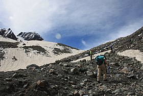 View of the northern side of the pass | |
| Elevation | 4,890 m (16,043 ft) |
| Location | Himachal Pradesh, India |
| Range | Himalayas |
| Coordinates | 31°47′13″N 77°59′46″E / 31.787°N 77.996°E |
 Map of Himachal Pradesh | |
Bhaba Pass connects the green and fertile Bhaba valley on the Kinnaur side with the barren high-elevation Pin valley on the Spiti side.
Overview edit
National Highway 22 runs alongside River Sutlej until Wangtu gives way to a narrow road leading to Katgaon and Kafnu. Katgaon and Kafnu are the base for one of the most beautiful trek routes in Himachal, the Bhaba trek. A moderate climb towards a glacial fed stream Bhaba river, to Bhabha Pass at 4,890 metres (16,040 ft) elevation to enter Pin Valley in Spiti is a challenging adventure. The first village in Spiti is Mud.[2] Another trek in the west from the Bhaba Pass gets into Parvati Valley of Kullu.
Distance edit
- Delhi: 545 km (339 mi)
- Shimla: 203 km (126 mi)
- Chandigarh: 315 km (196 mi)
Gallery edit
-
 The view north from the pass towards the Pin River
 -
 The top of the pass, and a mountain overlooking the pass.
 -
 The view south from the pass towards Bhaba valley
 -
 Icy terrain on the southern side of the pass.


References edit
- ^ Himachal Tourism"[1]". Himachal Tourism. Accessed 5 September 2019.
- ^ Kapadia, Harish (2001). Trekking and Climbing in the Indian Himalaya. Mechanicsburg, Pennsylvania: Stackpole Books. pp. 132–134. ISBN 0811729532.
- "Pin Bhaba Pass-A high-altitude crossover trek in Himachal Pradesh". Indiahikes. Retrieved 7 September 2019.