


Summary
The Bielefeld Stadtbahn is a metre gauge light rail (i.e. Stadtbahn) network in the German city of Bielefeld, North Rhine-Westphalia, Germany. The system does include some segments built to rapid transit standards. It is operated by moBiel, a subsidiary of the Bielefeld municipal authority (Stadtwerke), and integrated in the Westfalentarif transport association. It served 32.77 million passengers in 2012.[1]
| Bielefeld Stadtbahn | |||
|---|---|---|---|
 | |||
 | |||
| Overview | |||
| Locale | Bielefeld, North Rhine-Westphalia, Germany | ||
| Transit type | Light rail (Stadtbahn) | ||
| Number of lines | 4 | ||
| Number of stations | 62[1][2] | ||
| Annual ridership | 32.77 million (2012)[1] | ||
| Website | moBiel | ||
| Operation | |||
| Began operation | 1991[2] | ||
| Operator(s) | moBiel | ||
| Number of vehicles | 76[1][2] | ||
| Technical | |||
| System length | 36.9 km (22.9 mi)[1][2] | ||
| Track gauge | 1,000 mm (3 ft 3+3⁄8 in) | ||
| Average speed | 22.6 km/h (14.0 mph)[1][2] | ||
| |||

History edit
The old tram (Straßenbahn) network was rebuilt into a three-line Stadtbahn (light rail) network between 1978 and 1991, with the official inauguration of the Stadtbahn in 1991.[2] A fourth line was built to the university area and added to the network in 2002. Until 31 July 2021 four more supplemental lines were operated, which are now labeled with the normal line numbers. At the 1st of August 2021 the tram lines 3 & 4 changed its destinations. Line 3 ends at Dürkopp Tor 6, Line 4 in Stieghorst.
Operations edit
Hours of operation and frequencies edit
Trains run until 1 a.m. every day, with service starting at 4:30 a.m. every weekday, at 6:00 a.m. on Saturdays, and at 8:30 a.m. on Sundays and public holidays. Trains run every 5–10 minutes during the day and at least every 15 minutes late night and Sundays. On weekend nights, there is an hourly service, so there is a proposal for 24-hour service.
Lines edit
The Bielefeld Stadtbahn is made up of four lines, with a total track length of 66.3 kilometres (41.2 mi).[1][2] The mainline network operates over a total route length of 36.9 kilometres (22.9 mi),[1][2] serving 62 stops,[1][2] of which seven are underground stations.[3]
| Line | Route |
|---|---|
| 1 | Schildesche – Hauptbahnhof – Jahnplatz – Bethel – Brackwede – Senne |
| 2 | Altenhagen – Milse – Baumheide – Hauptbahnhof – Jahnplatz – Sieker |
| 3 | Babenhausen-Süd – Hauptbahnhof – Jahnplatz – Dürkopp Tor 6 |
| 4 | Lohmannshof – Universität – Hauptbahnhof – Jahnplatz – Sieker Mitte – Stieghorst |
Future service edit
In 2013 the municipal council decided to build a new Line "5" from the Kunsthalle Bielefeld via Jahnplatz and Kesselbrink to Heepen, with an opening planned for 2019. However, a citizens initiative voted against proceeding with this extension in 2014.[4]
Gallery edit
-
 Wittekindstraße station
 -
 Jahnplatz station
 -
 Hauptbahnhof station
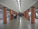
 -
 Hauptbahnhof station
 -
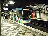
 M8D typical rolling stock
 -
 Vamos multiple-unit rolling stock
 -
 Tram in 1961


References edit
Inline references edit
- ^ a b c d e f g h i "Zahlen & Fakten" [Numbers & Facts] (in German). moBiel. May 2013. Archived from the original on 2017-11-17. Retrieved 2013-10-04.
- ^ a b c d e f g h i "StadtBahn - Immer auf Erfolgsschiene" [StadtBahn - Always on Track to Success] (in German). moBiel. Archived from the original on 2013-10-06. Retrieved 2013-10-04.
- ^ "StadtBahn-Netz - Die Linien der StadtBahn und ihre Umgebung" [Stadtbahn Network - The Lines of the Stadtbahn and Its Environs] (in German). moBiel. Archived from the original on 2017-09-27. Retrieved 2013-10-04.
- ^ "moBiel-Stellungnahme zum »Nein« bei der Bürgerabstimmung zum StadtBahn-Ausbau" [moBiel's opinion on "No" vote when citizens voted on light rail expansion] (in German). moBiel. 27 May 2014. Archived from the original on 29 May 2014. Retrieved 2014-05-28.
Bibliography edit
- Schwandl, Robert (2012). Schwandl's Tram Atlas Deutschland (in German and English) (3rd ed.). Berlin: Robert Schwandl Verlag. pp. 14–15. ISBN 9783936573336.
External links edit
- moBiel - official site (in German)
- Track plan of the Bielefeld Stadtbahn
52°02′21″N 8°29′49″E / 52.03917°N 8.49694°E