


Summary
Big Pine volcanic field is a volcanic field in Inyo County, California.[2] The volcanic field covers a surface area of 500 square kilometres (190 sq mi) within the Owens Valley east of the Sierra Nevada and consists of lava flows, one rhyolitic coulee and about 40 volcanic vents including cinder cones. Some vents are simple conical cinder cones while others are irregular scoria cones. Glaciers and former lakes have modified lava flows.
| Big Pine volcanic field | |
|---|---|
| Aberdeen volcanic field | |
 Cinder cones at Fish Springs, CA | |
| Highest point | |
| Coordinates | 37°00′N 118°15′W / 37.000°N 118.250°W[1] |
| Geography | |
 Big Pine volcanic field | |
| Geology | |
| Age of rock | Pleistocene |
| Mountain type | Volcanic field |
| Last eruption | 17,000 years ago. |
Volcanic activity in the field commenced 1.2 million years ago and was controlled by a number of faults which cross the valley. Activity continued into the Pleistocene with the youngest eruption generating cones and several lava flows about 17,000 years ago. A major road and the Los Angeles Aqueduct would be threatened if volcanic activity restarted at Big Pine.
Geography and geomorphology edit
The Big Pine volcanic field (also known as Aberdeen volcanic field[3]) lies in the Owens Valley,[4] around Aberdeen, California[5] and between the towns of Big Pine and Independence.[4] U.S. Route 395[4] and the Owens River run through the field, the latter is dammed north of the field in the Tinemaha Reservoir.[1]
The field covers c. 500 square kilometres (190 sq mi) and consists of 25 monogenetic volcanoes[6] and about 15 further vents.[7] The field features volcanic cones on both sides of the valley,[8] which take the form of symmetrical cones and irregular vents; the latter are found at the valley margin while the former are located on the valley floor.[9] Crater Mountain and Red Mountain are two cones in the field.[10] Pyroclastic material is usually found only close to the vents. A single rhyolite coulee is also part of the field.[11]

Around Aberdeen, lava flows from diverse vents form a large field with aa and pahoehoe forms[11] and neatly preserved surface features.[9] Lava flows reach lengths of 9 kilometres (5.6 mi)[3] and have thicknesses of 0.01–30 metres (0.39 in – 98 ft 5.10 in) and sometimes lava flows from separate cones overlap, such as in Papoose Canyon.[8]
In the past, pluvial lakes and glaciers extended over the Owens Valley. Volcanic activity occurred at the Big Pine volcanic field during that time and was influenced by these lakes and glaciers.[12] Owens Lake spread through much of the valley during glacial times and cut shorelines into the lava flows.[13] Glacial material and sediment covers some lava flows, and deep wells have found buried lava flows at depths of 250 metres (820 ft).[11]
The basement in the region is formed by plutonic rocks of Mesozoic age, metasedimentary and metavolcanic rocks which crop out in the White Mountains and the Sierra Nevada; the valley floor is covered with alluvium.[4] Tectonically, Owens Valley is a graben[1] formed by the movement of the Sierra Nevada-Great Valley block with respect to the rest of North America.[14] Farther south lies the Coso volcanic field, which is also geothermally active unlike Big Pine volcanic field.[15]
Geologic context edit
Various processes have been proposed to explain the volcanism in the Basin and Range province. These include tectonic spreading which triggered the upwelling of mantle material, convection within the mantle owing to temperature and viscosity differences, the aftereffects of Proterozoic crustal boundaries, mantle currents and release of water by the slab of the Farallon Plate and the delamination of crustal material.[16] There are a number of volcanic fields in Eastern California and Big Pine is one of these.[12]
Volcanic activity at Big Pine and Coso volcanic fields is linked to the tectonic spreading of the Basin and Range province,[15] and vents at Big Pine are associated with faults such as the Owens Valley fault, the Sierra Nevada fault and the White Mountains fault;[5] faults have offset lava flows of the field.[11] Seismic imaging of the crust beneath the Big Pine volcanic field indicates that the lithosphere is thinner there than elsewhere.[17]
Composition edit
The Big Pine volcanic field has erupted basaltic rocks[18] spanning a range of composition from alkali basalt to basanite, as well as one unit of silicic rocks.[6] Phenocrysts include olivine,[8] plagioclase and clinopyroxene.[19] The erupted rocks also contain xenoliths such as lherzolite, pyroxenite and wehrlite.[18]
The magmas erupted in the Big Pine volcanic field were generated by melting of lithospheric mantle that had been modified by subduction processes 1.8 billion years ago.[20][18] Research conducted in 2008 suggested that the mixing and melting of two origin magmas is necessary to generate the observed rock compositions.[21] After formation, the magmas at Big Pine quickly rose to the surface, preventing the formation of rhyolites which would require the magmas to stall within the crust.[22]
Climate and vegetation edit
Owens Valley is windy and sunny with yearly temperatures fluctuating 42 – −19 °C (107 – −2 °F) with strong diurnal temperature fluctuations. The Owens Valley lies in the rainshadow of the Sierra Nevada and thus the climate of the valley is dry with about 130 millimetres per year (5 in/year) precipitation.[23]
Vegetation in the valley is dominated by species adapted to arid and semiarid climates and includes Alkali sacaton, big sagebrush, greasewood, Nevada saltbush, rubber rabbitbrush, salt grass and shadscale. Plants cluster in places where water is available, such as on former stream courses, around depressions and along fault lines.[23]
Eruption history edit
Volcanism at Big Pine occurred during the Quaternary[24] and yielded a total volume of 0.5 cubic kilometres (0.12 cu mi) of rock.[18] Activity lasted from 1.2 million years ago[6] until 17,000 years ago,[5] with the bulk of the rocks erupted between 500,000 and 100,000 years ago.[7] Glacial isostasy seems to influence eruption rates in the field,[9] with eruptions suppressed during glacial times.[25]
The oldest volcanic structures, 1.2 million years old, are found in the Oak Creek area and only erosional remnants of them are encountered. The rhyolite was erupted about 990,000 years ago,[11] while later volcanism took place from 760,800 ± 22,800 years ago in Papoose Canyon (Papoose Canyon sequence) over 469,400 ± 9,200 years ago at Jalopy Cone, 90,500 ± 17,600 years ago at Quarry Cone, 61,600 ± 23,400 years ago at Volcanic Bomb Cone, 31,800 ± 12,100 years ago at Goodale Bee Cone (Aberdeen flow),[26][27] 27,000 years ago at the Blackrock Springs lava[13] to the about 17,000 years old Armstrong Canyon/Division Creek/Taboose Creek flows.[28]
These (Armstrong Canyon/Division Creek/Taboose Creek) flows were erupted during the same episode, which created Armstrong Canyon cone, a series of scoria cones and the three lava flows[28] along a 6 kilometres (3.7 mi) long tract of the Sierra Nevada fault.[29] This episode may have generated as much as 0.6 cubic kilometres (0.14 cu mi) of tephra, and lava flows interacted with water forming palagonite.[30] The lavas from this event and the Blackrock Springs lava were later eroded by Owens Lake during its last glacial maximum highstand.[13]
Hazards edit
The volcanoes in Eastern California such as Long Valley, Coso and Big Pine are still considered hazardous. The Los Angeles Aqueduct and US. Route 395 may be impacted by future eruptions at Big Pine;[12] the former contributes 250,000,000–620,000,000 cubic metres (200,000–500,000 acre⋅ft) of the water supply of Los Angeles (from less than one quarter to more than half of the city's water consumption)[31] while the latter is frequently used by people travelling between Mammoth Lakes and Los Angeles.[12]
Gallery edit
-
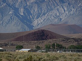
 Cinder cones in the background
 -
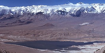 Tinemaha Reservoir, with cinder cones in the middle and left parts of the image
 -
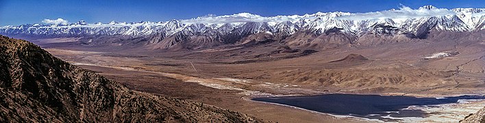 Owens Valley, with cones visible in the centre-right part of the image


References edit
- ^ a b c Blondes et al. 2008, p. 142.
- ^ Ormerod, Rogers & Hawkesworth 1991, p. 305.
- ^ a b "Big Pine Volcanic Field". Global Volcanism Program. Smithsonian Institution.
- ^ a b c d Beard & Glazner 1995, p. 4170.
- ^ a b c Vazquez & Woolford 2015, p. 2813.
- ^ a b c Blondes et al. 2008, p. 141.
- ^ a b Mordick & Glazner 2006, p. 113.
- ^ a b c Blondes et al. 2008, p. 143.
- ^ a b c Vazquez & Woolford 2015, p. 2815.
- ^ Mordick & Glazner 2006, p. 112.
- ^ a b c d e Vazquez & Woolford 2015, p. 2814.
- ^ a b c d Vazquez & Woolford 2015, p. 2812.
- ^ a b c Vazquez & Woolford 2015, p. 2823.
- ^ Dilek, Y.; Robinson, P. T. (1 December 2004). "Petrogenesis of Quaternary Potassic Volcanism (Big Pine Volcanic Field) Along the Owens Valley Fault Zone in the Eastern California Shear Zone". AGU Fall Meeting Abstracts. 33: T33C–1399. Bibcode:2004AGUFM.T33C1399D.
- ^ a b Mordick & Glazner 2006, p. 111.
- ^ Gazel et al. 2012, pp. 2–3.
- ^ Gazel et al. 2012, p. 3.
- ^ a b c d Beard & Glazner 1995, p. 4169.
- ^ Blondes et al. 2008, p. 144.
- ^ Ormerod, Rogers & Hawkesworth 1991, p. 316.
- ^ Blondes et al. 2008, p. 153.
- ^ Mordick & Glazner 2006, p. 123.
- ^ a b "Evaluation of the Hydrologic System and Selected Water-Management Alternatives in the Owens Valley, California". USGS. Retrieved 5 March 2018.
- ^ Ormerod, Rogers & Hawkesworth 1991, p. 306.
- ^ Vazquez & Woolford 2015, p. 2825.
- ^ Blondes et al. 2008, p. 140.
- ^ Vazquez & Woolford 2015, p. 2820.
- ^ a b Vazquez & Woolford 2015, p. 2821.
- ^ Vazquez & Woolford 2015, p. 2826.
- ^ Vazquez & Woolford 2015, p. 2822.
- ^ Hughes, Sara; Pincetl, Stephanie; Boone, Christopher (June 2013). "Triple exposure: Regulatory, climatic, and political drivers of water management changes in the city of Los Angeles". Cities. 32: 55–56. doi:10.1016/j.cities.2013.02.007. ISSN 0264-2751.
Sources edit
- Beard, Brian L.; Glazner, Allen F. (10 March 1995). "Trace element and Sr and Nd isotopic composition of mantle xenoliths from the Big Pine Volcanic Field, California". Journal of Geophysical Research: Solid Earth. 100 (B3): 4169–4179. Bibcode:1995JGR...100.4169B. doi:10.1029/94JB02883.
- Blondes, Madalyn S.; Reiners, Peter W.; Ducea, Mihai N.; Singer, Brad S.; Chesley, John (May 2008). "Temporal–compositional trends over short and long time-scales in basalts of the Big Pine Volcanic Field, California". Earth and Planetary Science Letters. 269 (1–2): 140–154. Bibcode:2008E&PSL.269..140B. doi:10.1016/j.epsl.2008.02.012. ISSN 0012-821X.
- Gazel, Esteban; Plank, Terry; Forsyth, Donald W.; Bendersky, Claire; Lee, Cin-Ty A.; Hauri, Erik H. (1 June 2012). "Lithosphere versus asthenosphere mantle sources at the Big Pine Volcanic Field, California". Geochemistry, Geophysics, Geosystems. 13 (6): n/a. Bibcode:2012GGG....13.AK06G. doi:10.1029/2012GC004060. hdl:1911/69887. ISSN 1525-2027. S2CID 27895756.
- Mordick, B. E.; Glazner, A. F. (1 July 2006). "Clinopyroxene thermobarometry of basalts from the Coso and Big Pine volcanic fields, California". Contributions to Mineralogy and Petrology. 152 (1): 111–124. Bibcode:2006CoMP..152..111M. doi:10.1007/s00410-006-0097-0. ISSN 0010-7999. S2CID 129853010.
- Ormerod, D. S.; Rogers, N. W.; Hawkesworth, C. J. (1 September 1991). "Melting in the lithospheric mantle: Inverse modelling of alkali-olivine basalts from the Big Pine Volcanic Field, California". Contributions to Mineralogy and Petrology. 108 (3): 305–317. Bibcode:1991CoMP..108..305O. doi:10.1007/BF00285939. ISSN 0010-7999. S2CID 128845027.
- Vazquez, J. A.; Woolford, J. M. (1 September 2015). "Late Pleistocene ages for the most recent volcanism and glacial-pluvial deposits at Big Pine volcanic field, California, USA, from cosmogenic 36Cl dating". Geochemistry, Geophysics, Geosystems. 16 (9): 2812–2828. Bibcode:2015GGG....16.2812V. doi:10.1002/2015GC005889. ISSN 1525-2027.