


Summary
The Biri Larosa Protected Landscape and Seascape is a protected area located in Northern Samar, Philippines, about 40 kilometres (25 mi) west of Catarman. It protects the Balicuatro Islands, composed of the island municipality of Biri and associated smaller islands, off the northwestern coast of Samar in the San Bernardino Strait. It also includes the coastal areas of the adjacent municipalities from which it derives the second half of its name – a combination of the first two letters of Lavezares, Rosario and San Jose.
| Biri Larosa Protected Landscape and Seascape | |
|---|---|
| Biri Rock Formations | |
IUCN category V (protected landscape/seascape) | |
 Biri Rock Formations | |
 Location in the Philippines | |
| Location | Northern Samar, Philippines |
| Nearest city | Calbayog |
| Coordinates | 12°36′27″N 124°24′52.56″E / 12.60750°N 124.4146000°E |
| Area | 33,492 hectares (82,760 acres) |
| Established | April 23, 2000 |
| Governing body | Department of Environment and Natural Resources |
The protected area spanned 33,492 hectares (82,760 acres) of land and sea when it was gazetted in 2000.[1] It is famous for its natural rock formations, as well as beaches, coral reefs, seagrass beds and mangrove forests.[2] The San Bernardino Strait, noted for its strong waves and currents, is also a popular surfing location in Samar.[3]
Description edit

The Balicuatro Islands are a group of 18 small islands situated about 11 kilometres (6.8 mi) northeast of Balicuatro Point, the northwestern tip of Samar island. It is divided into two subgroups by the Biri Channel, with the main island of Biri on the west composed of 7 islands, and the group of Cabauan Grande (Cabaongon) on the east.[4] The islands border the San Bernardino Strait and Philippine Sea and are separated from Samar by the Bani Channel.
Biri is the largest and northernmost of the Balicuatro Islands and is about 6.4 kilometres (4.0 mi) long northwest and southeast and 3.2 kilometres (2.0 mi) wide. It is generally high with a 200-foot (61 m) rocky perpendicular bluff on its northwestern side. Its coastline is covered with mangroves and has gravel beaches on its western side. It is surrounded by Macarite, Cagnipa, Talisay, Magesang and other smaller unnamed islands and is protected by fringing reefs. In 2000, the island municipality had a population of 8,700 distributed in 8 barangays.[2][5]
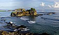
The island's main attraction is its seven gigantic rock formations, namely Magasang, Magsapad, Macadlaw, Puhunan, Bel-at, Caranas and Pinanahawan. These rock formations are a result of underwater tectonic plate movements and crashing waves over millions of years. Another unique feature of the island are the natural saltwater pools at Bel-at and Caranas where visitors can enjoy swimming in clear water.[3] To the south of Biri Channel along the coast of Lavezares are San Juan, Bani and Maravilla islands where several other white sand beaches can be found. On the coast of San Jose and Rosario are the islands of Cabaongon, Gilbert and the rest of the subgroup.

Biodiversity edit
Coral reefs comprise 81.53 hectares (201.5 acres) of the Biri Larosa protected area which supports 23 different reef fish species such as the siganid. It also contains 443 hectares (1,090 acres) of mangrove forests with 15 different mangrove species with Rhizophoraceae being dominant. They provide habitat to different local and migratory bird species such as the bridled tern, black-naped tern, greater crested tern and frigatebird, as well as several species of shellfish. Seagrasses cover about 284 hectares (700 acres) consisting of five species, including Cymodocea rotundata, Thalassia hemprichii, and Enhalus acoroides.[2][6]
The protected area faces threats from coral quarrying, blast fishing, and illegal cutting of mangroves.[2]
- Biri rock formations
-
 Mag-asang rock
 -
 Puhunan and Macadlaw behind it, as viewed from Bel-at
 -
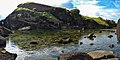 Caranas with tidal pool


Mythology edit
Biri is a sacred place for the Waray people since ancient times. They believe that Biri is the home of the goddess, Berbinota, who was initially a beautiful mortal woman who ruled the area's vicinity. Stories say that enchanted beings kidnapped the mortal Berbinota in an attempt to make her their ruler, which eventually led to her enthronement as a goddess.[7]
References edit
- ^ "Proclamation No. 291, s. 2000". Official Gazette of the Republic of the Philippines. Retrieved 31 March 2016.
- ^ a b c d Canoy, Ma. Easterluna S. & Roa-Quiaoit, Hilly Ann. "Ridge to Reef in the Philippines: A Showcase of Nine Emerging and Merging Initiatives" (PDF). Xavier University Press. Archived from the original (PDF) on 4 March 2016. Retrieved 31 March 2016.
- ^ a b Arnaiz, Vicky C. (6 April 2014). "A gem of ages: 7 island rock formations in Northern Samar". Philippine Daily Inquirer. Retrieved 31 March 2016.
- ^ "Report of the Philippine commission to the President. : January 31, 1900[-December 20, 1900] [Vol. 1, no. 1]". United States. Philippine Commission (1899-1900). Retrieved 31 March 2016.
- ^ Coast and Geodetic Survey. "Philippine Islands Sailing Direction, Third edition", p.323-4. Manila Bureau of Printing, 1906.
- ^ "Three Surveys of Mangrove Areas". Wild Bird Club of the Philippines. 20 August 2011. Retrieved 31 March 2016.
- ^ "A gem of ages: 7 island rock formations in Northern Samar". 5 April 2014.