


Summary
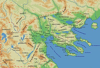
Bisaltia (Greek: Βισαλτία) or Bisaltica was an ancient country which was bordered by Sintice on the north, Crestonia on the west, Mygdonia on the south and was separated by Odomantis on the north-east and Edonis on the south-east by river Strymon.The eponymous inhabitants, known as the Bisaltae, were a Thracian people. Later, the region was annexed by the kingdom of Macedon and became one of its districts. The most important town in Bisaltia was the Greek city of Argilos.[1] There was also a river named Bisaltes in the region, which has not been certainly identified.
History edit
Bisaltia, along with Crestonia, was ruled by a Thracian prince at the time of the invasion of Xerxes I of Persia, but by the onset of the Peloponnesian War it was annexed by Macedon.
In Roman times, Bisaltia crossed a branch of the via Egnatia, in which the Roman sources (Itineraria) mention four horses change stations : Trinlo (=Tragilos), Graero, Arason (=Arolos) and Euporia.[2] In various sites of Bisaltia have been found so far several interesting inscriptions of imperial times.[3]
Important towns of Bisaltia were Argilos, Berge and Brea.
Today, Bisaltia is contained within the Serres regional unit and part of the Thessaloniki regional unit in Greece.
References edit
- ^ An Inventory of Archaic and Classical Poleis: An Investigation Conducted by The Copenhagen Polis Centre for the Danish National Research Foundation by Mogens Herman Hansen,2005,ISBN 0-19-814099-1,page 810,"There were three polis in Bisaltia of which one was considered a colony of Andros"
- ^ [1] Archived 2017-04-24 at the Wayback Machine D. C. Samsaris, Historical Geography of Eastern Macedonia during the Antiquity (in Greek), Thessaloniki 1976 (Society for Macedonian Studies), p. 24, 117-119. ISBN 960-7265-16-5.
- ^ D. C. Samsaris, La vallée du Bas-Strymon á l’ époque impériale (Contribution épigraphique á la topographie, l’ onomastique, l’ histoire et aux cultes de la province romaine de Macédoine), Dodona 18 (1989), fasc. 1, p. 215-225, n. 1-23 = The Packard Humanities Institute (Samsaris, Bas-Strymon 1, # PH150638)The Packard Humanities Institute (Samsaris, Bas-Strymon 2, # PH150639)The Packard Humanities Institute (Samsaris, Bas-Strymon 3, # PH150640)The Packard Humanities Institute (Samsaris, Bas-Strymon 4, # PH150641)The Packard Humanities Institute (Samsaris, Bas-Strymon 5, # PH150642)The Packard Humanities Institute (Samsaris, Bas-Strymon 6, # PH150643)The Packard Humanities Institute (Samsaris, Bas-Strymon 7, # PH150644)The Packard Humanities Institute (Samsaris, Bas-Strymon 8, # PH150645)The Packard Humanities Institute (Samsaris, Bas-Strymon 9, # PH150646)The Packard Humanities Institute (Samsaris, Bas-Strymon 10, # PH150647)The Packard Humanities Institute (Samsaris, Bas-Strymon 11, # PH150648)The Packard Humanities Institute (Samsaris, Bas-Strymon 12, # PH150649)The Packard Humanities Institute (Samsaris, Bas-Strymon 13, # PH150650)The Packard Humanities Institute (Samsaris, Bas-Strymon 14, # PH150651)The Packard Humanities Institute (Samsaris, Bas-Strymon 15, # PH150652)The Packard Humanities Institute (Samsaris, Bas-Strymon 16, # PH150653)The Packard Humanities Institute (Samsaris, Bas-Strymon 17, # PH150654)The Packard Humanities Institute (Samsaris, Bas-Strymon 18, # PH150655)The Packard Humanities Institute (Samsaris, Bas-Strymon 19, # PH150656)The Packard Humanities Institute (Samsaris, Bas-Strymon 20, # PH150657)The Packard Humanities Institute (Samsaris, Bas-Strymon 21 # PH150658)The Packard Humanities Institute (Samsaris, Bas-Strymon 22 # PH150659)The Packard Humanities Institute (Samsaris, Bas-Strymon 23 # PH150660)
External links edit
![]() Media related to Bisaltia at Wikimedia Commons
Media related to Bisaltia at Wikimedia Commons
40°57′30″N 23°23′10″E / 40.9583°N 23.3861°E