


Summary
Blekinge archipelago is an archipelago in the Baltic Sea, located in Blekinge in the south of Sweden.
| Designations | |
|---|---|
| Official name | Blekinge skärgård |
| Designated | 14 November 2001 |
| Reference no. | 1115[1] |

Geography edit
Blekinge archipelago stretches among almost the entire coastline of Blekinge, from west to east. It covers some 210,000 hectares (520,000 acres) including water; the landmass amounts to about 54,000 hectares (130,000 acres). The archipelago is dominated by a few large islands, Tjärö, Aspö, Hasslö, Tärnö and Sturkö, with smaller islands and skerries interspersed. In the whole archipelago area, some 85,000 people live, of whom 4,000 are islanders.[2] The island of Utlängan is the farthest out to sea of the archipelago's islands; only the lighthouse rock Utklippan is farther out.
The landscape is a diverse cultural landscape, characterised by mainly a mix between oak pastures and deciduous forest. For its size, the archipelago exhibits an unusually high biodiversity. Endangered species who find a habitat in the archipelago include Osmoderma eremita and Lecanographa amylacea.[2]
Culture edit
The towns of Karlshamn and Karlskrona are both located within the archipelago area; indeed, Karlskrona is mainly situated on Trossö island. The latter, having been founded as a naval base, is noted for its Baroque architecture and listed as a UNESCO World Heritage Site.
Shipbuilding has been a traditional local trade within the archipelago and the area is known for a traditional type of small boat, called blekingeeka and used for tasks like fishing and transporting stone locally.[3]
In the 1970s, the local diving club discovered a shipwreck in the Blekinge archipelago that was eventually identified by archaeologists as Gribshunden, a 15th-century Danish warship.[4][5] The shipwreck is significant as one of the best-preserved wreckages from the early modern period.[4][6]
Tjärö island was the site of the Sweden Social Web Camp from 2009 to 2013.[7]
Gallery edit
-
 Blekingeeka, a type of small boat traditionally used in the archipelago area.
 -
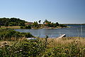
 Typical landscape (Almö island)
 -
 Typical landscape (Almö island)
 -
 Typical landscape Aspö island
 -
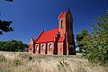 Church on Aspö island


References edit
- ^ "Blekinge skärgård". Ramsar Sites Information Service. Retrieved 25 April 2018.
- ^ a b "Blekinge Archipelago". Man and the Biosphere Programme. UNESCO. Archived from the original on 13 November 2013. Retrieved 4 July 2013.
- ^ "Världens farligaste blekingeeka". Marinumseum Karlskrona. Archived from the original on 3 March 2016. Retrieved 4 July 2013.
- ^ a b Warming, Rolf (2015-07-01). "Gribshunden: Significance and Preliminary Investigations". Combat Archaeology. Retrieved 2015-08-13.
- ^ Einarsson, Av Lars. "Ett skeppsvrak i Ronneby skärgård" [A shipwreck in the archipelago of Ronneby] (PDF) (in Swedish). Kalmar Läns Museum (Kalmar County Museum). Retrieved 2015-08-13.
- ^ "Medieval ship's 'sea monster' figurehead raised from Baltic". BBC News. 2015-08-12. Retrieved 2015-08-13.
- ^ "Sweden Social Web Camp | En unconference om internets framtid". www.swedensocialwebcamp.com. Retrieved 2023-09-26.
56°08′N 15°29′E / 56.133°N 15.483°E