


Summary
Bolton (2021 population 26,795)[1] is an unincorporated town that is the most populous community in the town of Caledon, Ontario, Canada, in the Regional Municipality of Peel. It is located beside the Humber River, approximately 50 kilometres northwest of Toronto. In regional documents, it is referred to as a 'Rural Service Centre'.[2] It has 26,795 residents in 9,158 total dwellings.[3] The downtown area that historically defined the village is in a valley, through which flows the Humber River. The village extends on either side of the valley to the north and south.
Bolton | |
|---|---|
 Queen Street (Highway 50) in Bolton | |
 Bolton  Bolton | |
| Coordinates: 43°52′50″N 79°44′17″W / 43.88056°N 79.73806°W | |
| Country | Canada |
| Province | Ontario |
| Regional municipality | Peel |
| Town | Caledon |
| Ward | 5 |
| Area | |
| • Land | 20.71 km2 (8.00 sq mi) |
| Population | |
| • Total | 26,795 |
| • Density | 1,294.0/km2 (3,351/sq mi) |
| Time zone | UTC-5 (EST) |
| • Summer (DST) | UTC-4 (EDT) |
| Forward Sortation Area | |
| Area codes | 905, 289, 365, and 742 |
| NTS Map | 30M13 Bolton |
| GNBC Code | FDJLH |
Geography edit
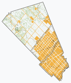
The conservation lands' forests dominate a large part of the north and the east, including along the Humber valley. These conservation lands have created several recreational areas, including parts of the Humber Valley Heritage Trail. Farmland and the protected Oak Ridges Moraine dominate the landscape surrounding the village.
There are two 400-series highways nearby, including Highway 427, about 9 km southeast (the highway's northern terminus being at Major Mackenzie Drive), and Highway 400, about 14 km east (exit at King Road).
To the northwest is the community of Glasgow, which pays homage to an earlier planned settlement also called Glasgow. The older settlement was established in 1855 but merged into Bolton in 1872.[4] Old Glasgow was supposed to house mill workers, it later served as a summer getaway for Toronto’s Jewish community from 1925 to 1950, then home to Edelweiss Ski Club. The planned community has naturalized again and now exists as Edelweiss Park and Humber Valley Heritage Trail.
History edit
The community, formerly known as Bolton Mills, was founded around 1822 when James Bolton helped build a flour mill for his relative George Bolton. By 1857, Bolton was a village with a population of 700 in the Township of Albion in Peel County. George Evans was a prominent early settler in the area.
It was established on the Humber River, on the line of the proposed Toronto, Grey and Bruce Railway. There were stages to and from Weston. The average price of land was $40 to $50 per acre.[5]
Transportation edit
Roads edit
Queen Street, formerly Highway 50, and now Peel Road 50, runs north-south through the community and is its main street. King Street (Peel Road 9) is the main east-west cross street. It continues outside Bolton beyond both ends and runs across the full width of Caledon.
Public transit edit
The Town of Caledon does not operate its own public transit system; however, a private contractor, Voyago, provides bus service in Bolton and travels south down Highway 50 to Highway 7/Queen Street (Brampton) at the border of Brampton and Vaughan to make connections with Brampton Transit and York Region Transit. Adult cash fares are $4.00 and there are no free transfers with these systems.[6] Caledon Community Services Transportation and Transhelp (operated by Region of Peel Accessible Transportation Services) provides paratransit services for the elderly, disabled, and infirm in Bolton and Caledon as a whole, and travels to select major destinations in Peel and York Regions.
History edit
There were two earlier privately-operated transit services running within Bolton: In 1999 a company named Caledon Transit Incorporated ran a trial bus service in the community.[7] In 2006, the growing population of Bolton prompted local resident Darren Parberry to start a second bus service with two routes using leased school buses, called Métis Transit. One route ran briefly in 2006.[8] Both services ceased operations due to low ridership.
Demographics edit
As of the 2021 census, the top three ethnic groups in Bolton are Italian (11,480; 43.4%), English (3,540; 13.4%) and Canadian (3,120; 11.8%).[9]
Organizations edit
- Freemasonry
- Kinsmen Club of Bolton, chartered in 1964
Media edit
The 1996 Warner Bros. film Twister and the 2005 film Four Brothers were partially shot here.
Education edit
Bolton is home to several public and Catholic schools:
Public Elementary Institutions:
- Allan Drive Middle School
- Ellwood Memorial Public School
- James Bolton Public School
- Macville Public School (just outside Bolton located in Caledon)
Public Secondary Institutions:
Catholic Elementary Institutions:
- Holy Family Elementary School
- St. John Paul II Elementary School
- St. John the Baptist Elementary School
- St. Nicholas Elementary School
Catholic Secondary Institutions:
- St. Michael Catholic Secondary School
Private Institutions:
- King's College School (Just outside Bolton located in Caledon)
- Creative Children's Montessori School
Notable residents edit
- Lorne Duguid – hockey player
- Keith McCreary – hockey player, former Chairman of the NHL Alumni, politician
- James East – politician
- Todd Elik – hockey player
- Organik – musician and founder of King of the Dot
- Steven Halko – hockey player
- Peter Holland – hockey player
- Andrew Mangiapane – hockey player
- Skye Sweetnam – singer
- Jason Saggo – UFC Fighter
- Joseph Shabason – ambient jazz musician
References edit
- ^ a b c "Bolton, Ontario (Population Centre)". Census Profile, Canada 2021 Census. Statistics Canada. 9 February 2022. Retrieved 12 February 2022.
- ^ "Bolton Residential Expansion Study". Town of Caledon. Retrieved 4 October 2017.
- ^ (Town of Caledon Population Distribution - June 30, 2006 - http://www.town.caledon.on.ca/contentc/townhall/statistics/Caledon_Population_Distribution_30JUN06.pdf Archived 2011-05-27 at the Wayback Machine)
- ^ "Glasgow - Humber Valley Heritage Trail Association Bolton Chapter".
- ^ The province of Ontario gazetteer and directory. H. McEvoy, Editor and Compiler, Toronto. Robertson & Cook, Publishers, 1869.
- ^ "Transit (Bolton)". Retrieved February 11, 2024.
- ^ "Transit History of Ontario Communities (A-B)". Home.cc.umanitoba.ca. Retrieved 7 November 2017.
- ^ "Wanted: Passengers for Bus Line (Original from transittoronto.ca)". Archived from the original on 2010-02-17. Retrieved 2010-01-25.
- ^ Canada, Government of Canada, Statistics (October 26, 2022). "Census Profile, 2021 Census of Population Profile table". www12.statcan.gc.ca. Retrieved October 26, 2022.
{{cite web}}: CS1 maint: multiple names: authors list (link)
External links edit
- Town of Caledon – official website
43°53′50″N 79°44′17″W / 43.89722°N 79.73806°W