


Summary
Boma is a port town on the Congo River, some 100 kilometres (62 mi) upstream from the Atlantic Ocean, in the Kongo Central Province of the Democratic Republic of the Congo (DRC), adjacent to the border with Angola. It had an estimated population of 162,521 in 2012.[2]
Boma | |
|---|---|
| Ville de Boma | |
 Boma Location in Democratic Republic of the Congo | |
| Coordinates: 5°51′S 13°03′E / 5.850°S 13.050°E | |
| Country | |
| Province | Kongo Central |
| Founded | 16th century |
| City status | 1963 |
| Communes | Kabondo, Kalamu, Nzadi |
| Government | |
| • Mayor | Senghor Mbutiyibi |
| Area | |
| • Total | 65 km2 (25 sq mi) |
| Elevation | 61 m (200 ft) |
| Population (2012)[2] | |
| • Total | 162,521 |
| • Density | 2,500/km2 (6,500/sq mi) |
| Time zone | UTC+1 (West Africa Time) |
| Climate | Aw |


Boma was the capital city of the Congo Free State and Belgian Congo (the modern Democratic Republic of the Congo) from 1 May 1886 to 1923, when the capital was moved to Léopoldville (since renamed Kinshasa). The port handles exports of tropical timber, bananas, cocoa, and palm products.
History edit
Boma was founded by European merchants in the 16th century as an entrepôt, including for the slave trade.[3] Trade was chiefly in the hands of Dutch merchants, but British, French and Portuguese firms also had factories there. No European power exercised sovereignty, though claims were from time to time put forward by Portugal.
British explorer Henry Morton Stanley arrived here on 9 August 1877, after crossing Africa from east to west.[4]
In 1884 the people of Boma were forced to grant a protectorate of their country to the International Association of the Congo, made up of European powers.[5] In 1886 King Leopold of Belgium established the Congo Free State, designating Boma as its capital. He ran the state as his personal fiefdom for several years, nearly enslaving many Congolese with a private military, and abusing them to force rubber production. International outrage and action by the Belgian legislature resulted in the government taking over supervision of what was established as the colony of the Belgian Congo in 1908.
Boma continued as the capital of the Belgian Congo until 1923.[6] Léopoldville, since renamed as Kinshasa, was designated as the new capital.
Transport edit
Boma lies on the north bank of the Congo River, some 100 km upstream from Muanda, where the river flows into the Atlantic Ocean. The great width and depth of the river allow seagoing ships to reach Boma, which is the second-largest port of DR Congo, after Matadi. Between 1889 and 1984, the port was served by a 610 mm gauge railway line from Tshela.
Notable people edit
- Antoine-Roger Bolamba, politician and poet, was born here in 1913.[7]
Climate edit
Köppen-Geiger climate classification system classifies its climate as tropical wet and dry (Aw).
The highest record temperature was 41 °C (106 °F) on February 25, 1976, while the lowest record temperature was 10 °C (50 °F) on October 21, 1976.[8]
| Climate data for Boma | |||||||||||||
|---|---|---|---|---|---|---|---|---|---|---|---|---|---|
| Month | Jan | Feb | Mar | Apr | May | Jun | Jul | Aug | Sep | Oct | Nov | Dec | Year |
| Record high °C (°F) | 34 (93) |
41 (106) |
39 (102) |
34 (93) |
39 (102) |
34 (93) |
32 (90) |
33 (91) |
36 (97) |
34 (93) |
34 (93) |
32 (90) |
41 (106) |
| Mean daily maximum °C (°F) | 32.6 (90.7) |
33.4 (92.1) |
33.8 (92.8) |
33.6 (92.5) |
32 (90) |
29.5 (85.1) |
26.7 (80.1) |
28 (82) |
29.4 (84.9) |
31.6 (88.9) |
32.4 (90.3) |
32.3 (90.1) |
31.3 (88.3) |
| Daily mean °C (°F) | 28.9 (84.0) |
29.5 (85.1) |
29.8 (85.6) |
29.5 (85.1) |
28.4 (83.1) |
26 (79) |
23.5 (74.3) |
24.8 (76.6) |
26.2 (79.2) |
28.4 (83.1) |
28.8 (83.8) |
28.7 (83.7) |
27.7 (81.9) |
| Mean daily minimum °C (°F) | 25.3 (77.5) |
25.7 (78.3) |
25.8 (78.4) |
25.5 (77.9) |
24.9 (76.8) |
22.6 (72.7) |
20.3 (68.5) |
21.6 (70.9) |
23.1 (73.6) |
25.2 (77.4) |
25.3 (77.5) |
25.2 (77.4) |
24.2 (75.6) |
| Record low °C (°F) | 20 (68) |
19 (66) |
19 (66) |
19 (66) |
17 (63) |
14 (57) |
12 (54) |
13 (55) |
14 (57) |
10 (50) |
15 (59) |
18 (64) |
10 (50) |
| Average rainfall mm (inches) | 83 (3.3) |
112 (4.4) |
126 (5.0) |
173 (6.8) |
69 (2.7) |
1 (0.0) |
1 (0.0) |
2 (0.1) |
8 (0.3) |
50 (2.0) |
149 (5.9) |
92 (3.6) |
866 (34.1) |
| Source 1: Climate-Data.org (altitude: 10m)[9] | |||||||||||||
| Source 2: Voodoo Skies for record temperatures[8] | |||||||||||||
Gallery edit
-
 Boma pier, 1899
 -
 Authorities at the end of the pier, Boma, 1899
 -
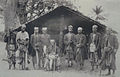 The nine old kings of Boma (phot. H. A. Shanu, 1898), Royal Museum for Central Africa
 -
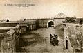 Fort de Shinkakasa – fortification on the Congo River near Boma
 -
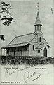 Church of Boma, which still exists; oldest in the country
 -
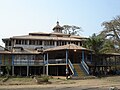 Residence of the Governor-General in Boma
 -
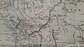 Henry Morton Stanley's map of the area during his expedition down the Congo River
 -
 Church of Boma, January 2007


See also edit
References edit
- ^ "Nouveaux maires à Matadi et à Boma". Infobascongo.net (in French). 25 November 2022. Retrieved 7 January 2023.
- ^ a b "World Gazetteer". Archived from the original on 2013-02-17.
- ^ The Modern world encyclopaedia : illustrated. Home Entertainment Library. 1935. OCLC 1091880941.
- ^ Stanley, H.M., 1899, Through the Dark Continent, London: G. Newnes, Vol. One ISBN 0486256677, Vol. Two, p. 359 ISBN 0486256685
- ^ One or more of the preceding sentences incorporates text from a publication now in the public domain: Chisholm, Hugh, ed. (1911). "Boma". Encyclopædia Britannica. Vol. 4 (11th ed.). Cambridge University Press. p. 181. This references H. M. Stanley, The Congo and the Founding of its Free State (London, 1885).
- ^ "Kinshasa – national capital, Democratic Republic of the Congo". britannica.com. Archived from the original on 18 October 2014. Retrieved 22 April 2021.
- ^ Albert S. Gerard, European-language writing in sub-Saharan Africa, Volume 1, p. 164, accessed March 2010
- ^ a b "Boma, Zaire". Voodoo Skies. Retrieved 2014-02-05.
- ^ "Climate: Boma - Climate graph, Temperature graph, Climate table". Climate-Data.org. Retrieved 2014-02-05.
External links edit
![]() Media related to Boma, Congo-Kinshasa at Wikimedia Commons
Media related to Boma, Congo-Kinshasa at Wikimedia Commons
- "(Boma)" – via Digital Public Library of America. (Images, etc.)
- Boma Panorama
05°51′00″S 13°03′00″E / 5.85000°S 13.05000°E