


Summary
Bonfim (Portuguese pronunciation: [bõˈfĩ]) is a municipality located in the mideast of the state of Roraima in Brazil. Its population is 12,557 and its area is 8,095 km2.[2] The city lies opposite the Takutu River from Lethem, Guyana. The Takutu River Bridge links Bonfim and Roraima with the town of Lethem and the Atlantic port of Georgetown, Guyana.[3]
Bonfim | |
|---|---|
Municipality | |
| The Municipality of Bonfim | |
 | |
 Flag  Seal | |
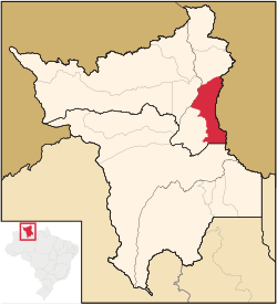 Location of Bonfim in the State of Roraima | |
 Bonfim Location in Brazil | |
| Coordinates: 03°21′36″N 59°49′58″W / 3.36000°N 59.83278°W | |
| Country | |
| Region | North |
| State | |
| Founded | 1 June 1982 |
| Government | |
| • Mayor | Joner Chagas (PRTB) |
| Area | |
| • Total | 8,095 km2 (3,125 sq mi) |
| Elevation | 92 m (302 ft) |
| Population (2020 [1]) | |
| • Total | 12,557 |
| • Density | 1.6/km2 (4.0/sq mi) |
| Time zone | UTC−4 (AMT) |
| Demonym | bonfinense |
| Website | bonfim.rr.gov.br |
Overview edit
In 1775, the Portuguese built Fort São Joaquim at the confluence of the Uraricoera and the Takutu River to prevent the Dutch from advancing into the area.[4] The ruins of the fort can still be seen.[5] In 1790, the Amerindians revolted, and the Portuguese retreated from the region.[4]
Bonfim started with the compound of a religious mission from the United States.[5] On 1 July 1982 it became a municipality[5] by Federal Bill Nº 7.009. On 28 March 2007 it was declared a free port for international trade by President Luiz Inácio Lula da Silva.[6]

The municipality is home to Amerindians of the Wapishana and Macushi tribes who live in the Wapixana, Macuxi, and Jabuti Indigenous Territories. Many of the indigenous community are tri-lingual speaking their own language, Portuguese and English.[5]
The economy is mainly based on livestock in particular cattle ranching and agriculture which an emphasis on cassava, bananas and cashew.[5]
Transport edit
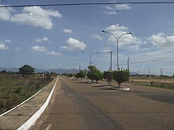
Bonfim is connected to the BR-401 which links the road network of Guyana to Boa Vista, the capital of Roraima, located 115 kilometres from Bonfim.[7]
References edit
- ^ IBGE 2020
- ^ "Bonfim". IBGE (in Portuguese). Retrieved 9 April 2021.
- ^ Stabroek News at [1] as of 16 March 2007
- ^ a b "Macuxi". Socio Ambiental. Retrieved 9 April 2021.
- ^ a b c d e "Historia da Cidade". Government of Bonfim (in Portuguese). Retrieved 9 April 2021.
- ^ "LEI Nº 11.732, DE 30 DE JUNHO DE 2008". Planalto.gov.br (in Portuguese). Retrieved 9 April 2021.
- ^ Reinaldo Imbrozio Barbosa; Ciro Campos (2001). "Detection and geographical distribution of clearing areas in the savannas ('lavrado') of Roraima using Google Earth web tool". Journal of Geography and Regional Planning: 125. ISSN 2070-1845.
External links edit
- Official site (in Portuguese)
 Media related to Bonfim (Roraima) at Wikimedia Commons