
KNOWPIA
WELCOME TO KNOWPIA

Boothby Graffoe 
Summary
Boothby Graffoe is a village and civil parish in the North Kesteven district of Lincolnshire, England. The population of the civil parish at the 2011 census was 223.[1] It is situated approximately 7 miles (10 km) south from the city and county town of Lincoln, and on the A607 Ermine Street Roman road.
| Boothby Graffoe | |
|---|---|
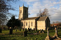 Church of St Andrew, Boothby Graffoe | |
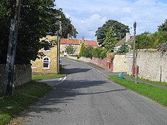 Main Street | |
 Boothby Graffoe Location within Lincolnshire | |
| Population | 223 (2011) |
| OS grid reference | SK985594 |
| • London | 110 mi (180 km) S |
| District | |
| Shire county | |
| Region | |
| Country | England |
| Sovereign state | United Kingdom |
| Post town | Lincoln |
| Postcode district | LN5 |
| Police | Lincolnshire |
| Fire | Lincolnshire |
| Ambulance | East Midlands |
| UK Parliament | |
Boothby Graffoe Grade II listed Anglican parish church is dedicated to St Andrew[2] The church was re-built in 1842. According to the parish registers of Wellingore, Boothby Graffoe's original church was destroyed by a T8-9 tornado (the strongest ever recorded in England) in 1666.[3]
To the west of the village lies the earthwork remains of Somerton Castle.[4]
See also edit
- "Boothby Graffoe", Genuki.org.uk. Retrieved 30 June 2011
- Spring line villages
- Boothby Graffoe (Comedian)
References edit
- ^ "Civil Parish population 2011". Neighbourhood Statistics. Office for National Statistics. Retrieved 23 April 2016.
- ^ Historic England. "St Andrews Church (1061976)". National Heritage List for England. Retrieved 30 June 2011.
- ^ Cox, J. Charles (1916). Lincolnshire. Methuen & Co. Ltd. p. 67.
- ^ Historic England. "Somerton Castle (326074)". Research records (formerly PastScape). Retrieved 30 June 2011.
External links edit
 Media related to Boothby Graffoe at Wikimedia Commons