
KNOWPIA
WELCOME TO KNOWPIA

Bornel 
Summary
Bornel is a commune in the Oise department in northern France. On 1 January 2016, the former communes Anserville and Fosseuse were merged into Bornel.[3] Bornel—Belle-Église station has rail connections to Beauvais and Paris.
Bornel | |
|---|---|
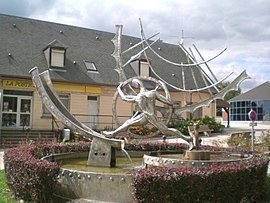 The fountain in Bornel | |
Location of Bornel .mw-parser-output .locmap .od{position:absolute}.mw-parser-output .locmap .id{position:absolute;line-height:0}.mw-parser-output .locmap .l0{font-size:0;position:absolute}.mw-parser-output .locmap .pv{line-height:110%;position:absolute;text-align:center}.mw-parser-output .locmap .pl{line-height:110%;position:absolute;top:-0.75em;text-align:right}.mw-parser-output .locmap .pr{line-height:110%;position:absolute;top:-0.75em;text-align:left}.mw-parser-output .locmap .pv>div{display:inline;padding:1px}.mw-parser-output .locmap .pl>div{display:inline;padding:1px;float:right}.mw-parser-output .locmap .pr>div{display:inline;padding:1px;float:left}html.skin-theme-clientpref-night .mw-parser-output .od,html.skin-theme-clientpref-night .mw-parser-output .od .pv>div,html.skin-theme-clientpref-night .mw-parser-output .od .pl>div,html.skin-theme-clientpref-night .mw-parser-output .od .pr>div{background:#000;color:#fff}html.skin-theme-clientpref-night .mw-parser-output .locmap{filter:grayscale(0.6)}@media(prefers-color-scheme:dark){html.skin-theme-clientpref-os .mw-parser-output .locmap{filter:grayscale(0.6)}html.skin-theme-clientpref-os .mw-parser-output .od,html.skin-theme-clientpref-os .mw-parser-output .od .pv>div,html.skin-theme-clientpref-os .mw-parser-output .od .pl>div,html.skin-theme-clientpref-os .mw-parser-output .od .pr>div{background:#000;color:#fff}}  Bornel  Bornel | |
| Coordinates: 49°11′56″N 2°12′36″E / 49.1989°N 2.21°E | |
| Country | France |
| Region | Hauts-de-France |
| Department | Oise |
| Arrondissement | Beauvais |
| Canton | Méru |
| Intercommunality | Sablons |
| Government | |
| • Mayor (2020–2026) | Dominique Toscani[1] |
| Area 1 | 23.73 km2 (9.16 sq mi) |
| Population (2021)[2] | 4,785 |
| • Density | 200/km2 (520/sq mi) |
| Time zone | UTC+01:00 (CET) |
| • Summer (DST) | UTC+02:00 (CEST) |
| INSEE/Postal code | 60088 /60540 |
| Elevation | 43–162 m (141–531 ft) (avg. 48 m or 157 ft) |
| 1 French Land Register data, which excludes lakes, ponds, glaciers > 1 km2 (0.386 sq mi or 247 acres) and river estuaries. | |
Population edit
|
| ||||||||||||||||||||||||||||||||||||||||||||||||||||||
| Source: EHESS[4] and INSEE (2007-2017)[5] | |||||||||||||||||||||||||||||||||||||||||||||||||||||||
See also edit
References edit
- ^ "Répertoire national des élus: les maires". data.gouv.fr, Plateforme ouverte des données publiques françaises (in French). 9 August 2021.
- ^ "Populations légales 2021". The National Institute of Statistics and Economic Studies. 28 December 2023.
- ^ Arrêté préfectoral 25 September 2015 (in French)
- ^ Des villages de Cassini aux communes d'aujourd'hui: Commune data sheet Bornel, EHESS (in French).
- ^ Population en historique depuis 1968, INSEE
Wikimedia Commons has media related to Bornel.