


Summary
Borovichsky District (Russian: Боровичский райо́н) is an administrative[1] and municipal[7] district (raion), one of the twenty-one in Novgorod Oblast, Russia. It is located in the east of the oblast and borders with Khvoyninsky District in the north, Moshenskoy District in the east, Udomelsky District of Tver Oblast in the southeast, Bologovsky District of Tver Oblast in the south, Okulovsky District in the west, and with Lyubytinsky District in the northwest. The area of the district is 3,100 square kilometers (1,200 sq mi).[3] Its administrative center is the town of Borovichi (which is not administratively a part of the district).[1] Population: 15,675 (2010 Census);[4] 19,085 (2002 Census);[9] 21,648 (1989 Census).[10]
Borovichsky District
Боровичский район | |
|---|---|
 River landscape in Borovichsky District | |
 Flag  Coat of arms | |
 Location of Borovichsky District in Novgorod Oblast | |
| Coordinates: 58°16′N 34°07′E / 58.267°N 34.117°E | |
| Country | Russia |
| Federal subject | Novgorod Oblast[1] |
| Established | October 1, 1927[2] |
| Administrative center | Borovichi[1] |
| Area | |
| • Total | 3,100 km2 (1,200 sq mi) |
| Population | |
| • Total | 15,675 |
| • Estimate (2018)[5] | 64,063 (+308.7%) |
| • Density | 5.1/km2 (13/sq mi) |
| • Urban | 0% |
| • Rural | 100% |
| Administrative structure | |
| • Administrative divisions | 10 Settlements |
| • Inhabited localities[6] | 323 rural localities |
| Municipal structure | |
| • Municipally incorporated as | Borovichsky Municipal District[7] |
| • Municipal divisions[7] | 1 urban settlements, 16 rural settlements |
| Time zone | UTC+3 (MSK |
| OKTMO ID | 49606000 |
| Website | http://www.boradmin.ru/ |
Geography edit
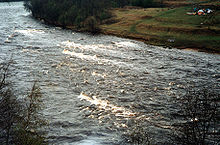
Borovichsky District is located in the northeastern part of the Valday Hills in the basin of the Msta River. The Msta crosses the district from southeast to northwest. Msta's rapids are located in the district. The principal tributaries of the Msta within the limits of the district are the Uver and the Velgiya; both are right. The northeast of the district lies in the basin of the tributaries of the Uver, of which the Udina is the biggest one.
There are many lakes in the district. One major lake, Lake Piros, is located in the south of the district and is shared with Tver Oblast. There are clusters of lakes in the east and in the northeast. The biggest lakes in those areas are Lake Limandrovo, the source of the Velgiya, and Lake Sheregodra.
Much of the district's territory is covered by forests.
History edit
The Msta River was an important waterway since at least the 10th century, since it connected Novgorod with the basins of the Volga and Northern Dvina Rivers. In 947 in particular, Olga of Kiev founded a number of pogosts on the river.[11] In the course of the administrative reform carried out in 1708 by Peter the Great, the territory was included into Ingermanland Governorate (known since 1710 as Saint Petersburg Governorate). In 1727, separate Novgorod Governorate was split off. In 1770, Borovichi was chartered, and in 1773, Borovichsky Uyezd was established. In 1776, the area was transferred to Novgorod Viceroyalty. In 1796, the viceroyalty was abolished and Borovichsky Uyezd was transferred to Novgorod Governorate.
In August 1927, the governorates and uyezds were abolished. Borovichsky District, with the administrative center in the town of Borovichi,[12] was established within Borovichi Okrug of Leningrad Oblast effective October 1, 1927.[2] It included parts of Borovichskaya, Vasilyevskaya, Volokskaya, and Opechenskaya Volosts of former Borovichsky Uyezd.[12] On July 23, 1930, the okrugs were abolished, and the districts were directly subordinated to the oblast.[13] The town of Borovichi was initially subordinated to the district, but from 1930 it became a town under oblast jurisdiction.[12] On July 5, 1944, Borovichsky District was transferred to newly established Novgorod Oblast,[14] where it remained ever since.
Effective October 1, 1927,[2] Opechensky District with the administrative center in the selo of Opechensky Posad was also established as a part of Borovichi Okrug of Leningrad Oblast.[15] On September 20, 1931, Opechensky District was abolished and merged into Borovichsky District, but on August 3, 1939 it was restored.[15] On July 5, 1944, the district was transferred to Novgorod Oblast.[15] On November 17, 1960, Opechensky District was abolished, and its area was split between Borovichsky and Moshenskoy Districts.[16]
Also effective October 1, 1927,[2] Konchansky District with the administrative center in the selo of Konchanskoye was established as a part of Borovichi Okrug of Leningrad Oblast.[17] On January 1, 1932, Konchansky District was abolished and split between Borovichsky, Moshenskoy, and Khvoyninsky Districts.[17]
Another district established effective October 1, 1927[2] as a part of Borovichi Okrug of Leningrad Oblast was Uglovsky District.[18] Its administrative center was in the railway station of Uglovka.[18] On January 1, 1932, Uglovsky District was abolished and split between Bologovsky, Borovichsky, and Okulovsky Districts.[18]
Administrative and municipal status edit
Within the framework of administrative divisions, Borovichsky District is one of the twenty-one in the oblast.[1] The town of Borovichi serves as its administrative center, despite being incorporated separately as a town of oblast significance—an administrative unit with the status equal to that of the districts.[1]
As a municipal division, the district is incorporated as Borovichsky Municipal District, with the town of oblast significance of Borovichi being incorporated within it as Borovichi Urban Settlement.[7]
Economy edit
Agriculture edit
As of 2010, there were 22 large-scale farms and 170 smaller farms. Of all agricultural production, 62% was in meat, milk, and eggs production.[3]
Transportation edit
Borovichi is connected by a railroad with Uglovka and thus with the railway between Moscow and St. Petersburg.
The district is well connected by all-seasonal roads. In particular, roads connecting Borovichi with Tikhvin (via Lyubytino), Okulovka, and Pestovo all cross the district, and there are many local roads with bus traffic.
Culture and recreation edit

The district contains 14 cultural heritage monuments of federal significance and additionally 201 objects classified as cultural and historical heritage of local significance.[19] Most of the federal monuments are archaeological sites.
There is one museum in the district, the Suvorov estate in the selo of Konchansko-Suvorovskoye.[20] Generalissimo Alexander Suvorov, a Russian military commander notable for military operations against the Ottoman Empire and against the army of Napoleon in the late 18th century, owned the estate and visited it on many occasions. In particular, he spent in the estate several years during his retirement.
Notable residents edit
- Grigory Romanov (1923 in Zikhnovo – 2008), Soviet politician
References edit
Notes edit
- ^ a b c d e f Law #559-OZ
- ^ a b c d e Snytko et al., p. 85
- ^ a b c Территория вселения "Боровичский муниципальный район" (in Russian). Русский век. 2012. Retrieved May 23, 2012.
- ^ a b Russian Federal State Statistics Service (2011). Всероссийская перепись населения 2010 года. Том 1 [2010 All-Russian Population Census, vol. 1]. Всероссийская перепись населения 2010 года [2010 All-Russia Population Census] (in Russian). Federal State Statistics Service.
- ^ "26. Численность постоянного населения Российской Федерации по муниципальным образованиям на 1 января 2018 года". Federal State Statistics Service. Retrieved January 23, 2019.
- ^ Resolution #121
- ^ a b c d Law #373-OZ
- ^ "Об исчислении времени". Официальный интернет-портал правовой информации (in Russian). June 3, 2011. Retrieved January 19, 2019.
- ^ Russian Federal State Statistics Service (May 21, 2004). Численность населения России, субъектов Российской Федерации в составе федеральных округов, районов, городских поселений, сельских населённых пунктов – районных центров и сельских населённых пунктов с населением 3 тысячи и более человек [Population of Russia, Its Federal Districts, Federal Subjects, Districts, Urban Localities, Rural Localities—Administrative Centers, and Rural Localities with Population of Over 3,000] (XLS). Всероссийская перепись населения 2002 года [All-Russia Population Census of 2002] (in Russian).
- ^ Всесоюзная перепись населения 1989 г. Численность наличного населения союзных и автономных республик, автономных областей и округов, краёв, областей, районов, городских поселений и сёл-райцентров [All Union Population Census of 1989: Present Population of Union and Autonomous Republics, Autonomous Oblasts and Okrugs, Krais, Oblasts, Districts, Urban Settlements, and Villages Serving as District Administrative Centers]. Всесоюзная перепись населения 1989 года [All-Union Population Census of 1989] (in Russian). Институт демографии Национального исследовательского университета: Высшая школа экономики [Institute of Demography at the National Research University: Higher School of Economics]. 1989 – via Demoscope Weekly.
- ^ "История города и городского управления" (in Russian). Администрация Боровичского муниципального района. Archived from the original on November 5, 2012. Retrieved May 23, 2012.
- ^ a b c Snytko et al., pp. 96–97
- ^ Snytko et al., pp. 87–88
- ^ Snytko et al., p. 99
- ^ a b c Snytko et al., pp. 125–126
- ^ Snytko et al., p. 148
- ^ a b Snytko et al., pp. 105–106
- ^ a b c Snytko et al., pp. 139–140
- ^ Памятники истории и культуры народов Российской Федерации (in Russian). Russian Ministry of Culture. Retrieved June 2, 2016.
- ^ Музей-усадьба А.В.Суворова в с. Кончанско-Суворовское (in Russian). Российская сеть культурного наследия. Retrieved May 23, 2012.
Sources edit
- Новгородская областная Дума. Областной закон №559-ОЗ от 11 ноября 2005 г. «Об административно-территориальном устройстве Новгородской области», в ред. Областного закона №730-ОЗ от 26 февраля 2015 г. «О внесении изменений в Областной закон "Об административно-территориальном устройстве Новгородской области"». Вступил в силу 1 января 2006 г. Опубликован: "Новгородские ведомости", №75, 23 ноября 2005 г. (Novgorod Oblast Duma. Oblast Law #559-OZ of November 11, 2005 On the Administrative-Territorial Structure of Novgorod Oblast, as amended by the Oblast Law #730-OZ of February 26, 2015 On Amending the Oblast Law "On the Administrative-Territorial Structure of Novgorod Oblast". Effective as of January 1, 2006.).
- Администрация Новгородской области. Постановление №121 от 8 апреля 2008 г. «Об реестре административно-территориального устройства области», в ред. Постановления №408 от 4 августа 2014 г. «О внесении изменений в реестр административно-территориального устройства области». Опубликован: "Новгородские ведомости", №49–50, 16 апреля 2008 г. (Administration of Novgorod Oblast. Resolution #121 of April 8, 2008 On the Registry of the Administrative-Territorial Structure of Novgorod Oblast, as amended by the Resolution #408 of August 4, 2014 On Amending the Registry of the Administrative-Territorial Structure of Novgorod Oblast. ).
- Новгородская областная Дума. Областной закон №373-ОЗ от 22 декабря 2004 г. «Об установлении границ муниципальных образований, входящих в состав территории Боровичского муниципального района, наделении их статусом городского и сельских поселений, определении административных центров и перечня населённых пунктов, входящих в состав территорий поселений», в ред. Областного закона №216-ОЗ от 1 марта 2013 г. «О внесении изменений в некоторые областные законы, содержащие перечни населённых пунктов, входящих в состав территорий поселений». Вступил в силу со дня, следующего за днём официального опубликования. Опубликован: "Новгородские ведомости", №2, 12 января 2005 г. (Novgorod Oblast Duma. Oblast Law #373-OZ of December 22, 2004 On Establishing the Borders of the Municipal Formations Within the Territory of Borovichsky Municipal District, on Granting Them the Status of Urban and Rural Settlements, on Establishing Their Administrative Centers, and on Compiling the Lists of Inhabited Localities Within the Settlement Territories, as amended by the Oblast Law #216-OZ of March 1, 2013 On Amending Various Oblast Laws Containing the Lists of Inhabited Localities Within the Settlement Territories. Effective as of the day following the day of the official publication.).
- Снытко, О. В.; et al. (2009). С. Д. Трифонов; Т. Б. Чуйкова; Л. В. Федина; А. Э. Дубоносова (eds.). Административно-территориальное деление Новгородской губернии и области 1727-1995 гг. Справочник (PDF) (in Russian). Saint Petersburg. Retrieved May 22, 2012.
{{cite book}}: CS1 maint: location missing publisher (link)