


Summary
Boroujen (Persian: بروجن), also Romanized as Borojen, Borūjen, Boroojen, Broojen; also known as Urjen and Oorjen,[4] is a city in the Central District of Borujen County, Chaharmahal and Bakhtiari province, Iran, and serves as capital of the county.[5] The city is populated by Persians with a minority of Lurs and Turkic peoples.[6][7]
Borujen
Persian: بروجن Borojen | |
|---|---|
City | |
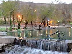 Siasard Touristic Area at sunset in summer | |
 Borujen | |
| Coordinates: 31°58′04″N 51°17′22″E / 31.96778°N 51.28944°E[1] | |
| Country | Iran |
| Province | Chaharmahal and Bakhtiari |
| County | Borujen |
| District | Central |
| Government | |
| • Mayor | Garshasb Rigi |
| Elevation | 2,197 m (7,208 ft) |
| Population (2016)[3] | |
| • Total | 57,071 |
| Time zone | UTC+3:30 (IRST) |
| Area code | 382 |
At the 2006 census, its population was 49,077 in 12,828 households.[8] The following census in 2011 counted 52,694 people in 14,858 households.[9] The latest census in 2016 showed a population of 57,071 people in 17,228 households.[3]
Weather and climate edit
Borujen is well known for its extremely cold weather, usually mentioned as one of the coldest Iranian cities in national weather forecasts. It is located on an altitude of about 2197 m above sea level. Its climate is usually a combination of moderate summers and very cold winters. Snow days are normally 122 days per year, and the temperature could reach -27 °C. The maximum observed temperature has been 36 °C. Average annular precipitation is 243 mm (24% in the spring, 1% in the summer, 33% in the fall, and 44% in the winter).
Borujen has one of the highest elevation of Iran's cities, making it rich and fruitful in terms of flora and fauna.[original research?] The city is located in a valley with the same name, which has a total area of 580 m² in the eastern part of Chaharmahal and Bakhtiari province.
| Climate data for Boroujen(1988-2005, Elevation=2197m) | |||||||||||||
|---|---|---|---|---|---|---|---|---|---|---|---|---|---|
| Month | Jan | Feb | Mar | Apr | May | Jun | Jul | Aug | Sep | Oct | Nov | Dec | Year |
| Mean daily maximum °C (°F) | 3.8 (38.8) |
6.4 (43.5) |
11.0 (51.8) |
17.1 (62.8) |
22.7 (72.9) |
28.7 (83.7) |
31.5 (88.7) |
31.0 (87.8) |
27.2 (81.0) |
20.7 (69.3) |
13.4 (56.1) |
8.0 (46.4) |
18.5 (65.2) |
| Daily mean °C (°F) | −1.9 (28.6) |
0.6 (33.1) |
4.8 (40.6) |
10.2 (50.4) |
14.6 (58.3) |
19.1 (66.4) |
22.2 (72.0) |
21.3 (70.3) |
17.3 (63.1) |
11.9 (53.4) |
6.2 (43.2) |
1.9 (35.4) |
10.7 (51.2) |
| Mean daily minimum °C (°F) | −7.7 (18.1) |
−5.2 (22.6) |
−1.4 (29.5) |
3.3 (37.9) |
6.5 (43.7) |
9.5 (49.1) |
13.0 (55.4) |
11.6 (52.9) |
7.4 (45.3) |
3.0 (37.4) |
−0.9 (30.4) |
−4.2 (24.4) |
2.9 (37.2) |
| Average precipitation mm (inches) | 45.3 (1.78) |
33.6 (1.32) |
54.1 (2.13) |
27.4 (1.08) |
8.9 (0.35) |
1.2 (0.05) |
0.8 (0.03) |
0.1 (0.00) |
0.2 (0.01) |
5.2 (0.20) |
23.7 (0.93) |
53.7 (2.11) |
254.2 (9.99) |
| Average relative humidity (%) | 60 | 53 | 47 | 40 | 33 | 24 | 24 | 23 | 24 | 34 | 45 | 54 | 38 |
| Average dew point °C (°F) | −9.0 (15.8) |
−8.4 (16.9) |
−6.2 (20.8) |
−2.9 (26.8) |
−0.9 (30.4) |
−0.8 (30.6) |
2.3 (36.1) |
0.8 (33.4) |
−2.2 (28.0) |
−3.2 (26.2) |
−5.1 (22.8) |
−7.0 (19.4) |
−3.5 (25.6) |
| Mean monthly sunshine hours | 215.0 | 226.8 | 242.8 | 256.4 | 333.4 | 359.8 | 342.3 | 341.5 | 319.2 | 293.6 | 230.0 | 219.4 | 3,380.2 |
| Source: IRIMO [10] | |||||||||||||
Gallery edit
-
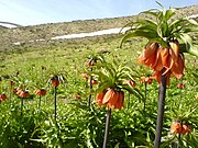 Inverted Tulips, Siasard Area
 -
 Mosalla Bridge
 -
 Boroujen-Isfahan Road


Higher education edit
Borujen hosts several higher education institutes:
- Payam-e-Noor University of Boroujen (in Persian)
- Islamic Azad University of Boroujen (in Persian)
- Nursing Faculty of Boroujen (in Persian)
- Boroujen Technical School (in Persian)
References edit
- ^ OpenStreetMap contributors (1 April 2023). "Borujen, Borujen County" (Map). OpenStreetMap. Retrieved 1 April 2023.
- ^ "ايستگاه ها - اداره کل هواشناسي استان چهارمحال و بختياري". Archived from the original on 19 October 2004.
- ^ a b "Census of the Islamic Republic of Iran, 1395 (2016)". AMAR (in Persian). The Statistical Center of Iran. p. 14. Archived from the original (Excel) on 24 May 2019. Retrieved 19 December 2022.
- ^ Borujen can be found at GEOnet Names Server, at this link, by opening the Advanced Search box, entering "-3056915" in the "Unique Feature Id" form, and clicking on "Search Database".
- ^ Habibi, Hassan (21 June 1369). "Approval of the organization and chain of citizenship of the elements and units of the national divisions of Chaharmahal and Bakhtiari province, centered in the city of Shahrekord". Islamic Parliament Research Center (in Persian). Ministry of Interior, Defense Political Commission of the Government Board. Archived from the original on 21 September 2016. Retrieved 2 December 2023.
- ^ "Language distribution: Chahar Mahal va Bakhtiari Province". Iran Atlas. Archived from the original on 4 December 2017. Retrieved 25 March 2021.
- ^ Anonby, Erik. "Atlas of the Languages of Iran: A working classification". Iran Atlas. Archived from the original on 29 December 2019. Retrieved 27 March 2021.
- ^ "Census of the Islamic Republic of Iran, 1385 (2006)". AMAR (in Persian). The Statistical Center of Iran. p. 14. Archived from the original (Excel) on 20 September 2011. Retrieved 25 September 2022.
- ^ "Census of the Islamic Republic of Iran, 1390 (2011)". Syracuse University (in Persian). The Statistical Center of Iran. p. 14. Archived from the original (Excel) on 16 January 2023. Retrieved 19 December 2022.
- ^ Archived February 17, 2016, at the Wayback Machine
External links edit
- Municipal Borujen
- Governor Borujen
- Borujen News Agency
- https://web.archive.org/web/20110712025929/http://broujencity.ir