
KNOWPIA
WELCOME TO KNOWPIA

Bouilh-Devant 
Summary
Bouilh-Devant is a commune in the Hautes-Pyrénées department in southwestern France.
Bouilh-Devant | |
|---|---|
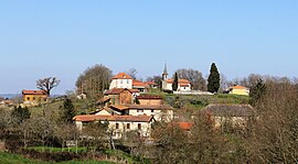 View of Bouilh-Devant | |
 Coat of arms | |
Location of Bouilh-Devant .mw-parser-output .locmap .od{position:absolute}.mw-parser-output .locmap .id{position:absolute;line-height:0}.mw-parser-output .locmap .l0{font-size:0;position:absolute}.mw-parser-output .locmap .pv{line-height:110%;position:absolute;text-align:center}.mw-parser-output .locmap .pl{line-height:110%;position:absolute;top:-0.75em;text-align:right}.mw-parser-output .locmap .pr{line-height:110%;position:absolute;top:-0.75em;text-align:left}.mw-parser-output .locmap .pv>div{display:inline;padding:1px}.mw-parser-output .locmap .pl>div{display:inline;padding:1px;float:right}.mw-parser-output .locmap .pr>div{display:inline;padding:1px;float:left}html.skin-theme-clientpref-night .mw-parser-output .od,html.skin-theme-clientpref-night .mw-parser-output .od .pv>div,html.skin-theme-clientpref-night .mw-parser-output .od .pl>div,html.skin-theme-clientpref-night .mw-parser-output .od .pr>div{background:#000;color:#fff}html.skin-theme-clientpref-night .mw-parser-output .locmap{filter:grayscale(0.6)}@media(prefers-color-scheme:dark){html.skin-theme-clientpref-os .mw-parser-output .locmap{filter:grayscale(0.6)}html.skin-theme-clientpref-os .mw-parser-output .od,html.skin-theme-clientpref-os .mw-parser-output .od .pv>div,html.skin-theme-clientpref-os .mw-parser-output .od .pl>div,html.skin-theme-clientpref-os .mw-parser-output .od .pr>div{background:#000;color:#fff}}  Bouilh-Devant  Bouilh-Devant | |
| Coordinates: 43°19′53″N 0°15′38″E / 43.3314°N 0.2606°E | |
| Country | France |
| Region | Occitania |
| Department | Hautes-Pyrénées |
| Arrondissement | Tarbes |
| Canton | Val d'Adour-Rustan-Madiranais |
| Intercommunality | Adour Madiran |
| Government | |
| • Mayor (2020–2026) | Marie-Josée Rottoli[1] |
| Area 1 | 2.99 km2 (1.15 sq mi) |
| Population (2021)[2] | 20 |
| • Density | 6.7/km2 (17/sq mi) |
| Time zone | UTC+01:00 (CET) |
| • Summer (DST) | UTC+02:00 (CEST) |
| INSEE/Postal code | 65102 /65140 |
| Elevation | 245–381 m (804–1,250 ft) (avg. 341 m or 1,119 ft) |
| 1 French Land Register data, which excludes lakes, ponds, glaciers > 1 km2 (0.386 sq mi or 247 acres) and river estuaries. | |
Population edit
| Year | Pop. | ±% p.a. |
|---|---|---|
| 1968 | 39 | — |
| 1975 | 31 | −3.23% |
| 1982 | 35 | +1.75% |
| 1990 | 27 | −3.19% |
| 1999 | 23 | −1.77% |
| 2009 | 20 | −1.39% |
| 2014 | 22 | +1.92% |
| 2020 | 19 | −2.41% |
| Source: INSEE[3] | ||
See also edit
References edit
- ^ "Répertoire national des élus: les maires" (in French). data.gouv.fr, Plateforme ouverte des données publiques françaises. 13 September 2022.
- ^ "Populations légales 2021". The National Institute of Statistics and Economic Studies. 28 December 2023.
- ^ Population en historique depuis 1968, INSEE
Wikimedia Commons has media related to Bouilh-Devant.