
KNOWPIA
WELCOME TO KNOWPIA

Boulonnais (land area) 
Summary
The Boulonnais (French pronunciation: [bu.lɔ.nɛ]) is a coastal area of northern France,[1] around Calais and Boulogne-sur-Mer. It has a curved belt of chalk downs which run into the sea at both ends, and geologically is the east end of the Weald-Artois Anticline.[2]

Administration edit
The Pays Boulonnais is subdivided into 3 intercommunalities: the Communauté d'agglomération du Boulonnais, the Communauté de communes de la Terre des Deux Caps & the Communauté de communes de Desvres - Samer.
Towns and villages of the Boulonnais edit
See also edit
External links edit
- Tourism in Boulogne and in the Boulonnais region
- Tourism in Pas-de-Calais
- Caps et Marais d'Opale Regional Natural Park
Photo gallery edit
-
 Wimille: The Column of the Grande Armée
 -
 Boulogne-sur-Mer: The Belfry, UNESCO World Heritage Site
 -
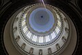 Boulogne-sur-Mer: Inside the basilica Notre Dame.
 -
 Boulogne-sur-Mer: Basilica and Castle Museum.
 -
 Boulogne-sur-Mer: around the fortifications.
 -
 Villa in Wimereux.
 -
 Villa in Wimereux.
 -
 Wimereux: looking north.
 -
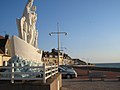 Le Portel: Notre Dame de Boulogne statue
 -
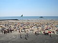 Le Portel: beach with view on the Heurt Fort
 -
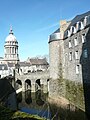
 Hardelot Castle
 -
 Condette:Mirrors Lake, around the Hardelot Castle


References edit
- ^ Townson, W.G.; Wimbledon, W.A. (1979-01-01). "The Portlandian strata of the Bas Boulonnais, France". Proceedings of the Geologists' Association. 90 (1–2): 81–91. Bibcode:1979PrGA...90...81T. doi:10.1016/S0016-7878(79)80035-8. ISSN 0016-7878.
- ^ Jones, David K. C. (1999-01-01). "On the uplift and denudation of the Weald". Geological Society, London, Special Publications. 162 (1): 25–43. Bibcode:1999GSLSP.162...25J. doi:10.1144/GSL.SP.1999.162.01.03. ISSN 0305-8719. S2CID 128889275.
50°43′N 1°46′E / 50.717°N 1.767°E