
KNOWPIA
WELCOME TO KNOWPIA

Bourdeaux 
Summary
Bourdeaux (French pronunciation: [buʁdo]; Occitan: Bordèus) is a commune in the Drôme department in southeastern France.
Bourdeaux | |
|---|---|
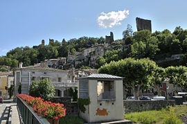 The old village | |
 Coat of arms | |
Location of Bourdeaux .mw-parser-output .locmap .od{position:absolute}.mw-parser-output .locmap .id{position:absolute;line-height:0}.mw-parser-output .locmap .l0{font-size:0;position:absolute}.mw-parser-output .locmap .pv{line-height:110%;position:absolute;text-align:center}.mw-parser-output .locmap .pl{line-height:110%;position:absolute;top:-0.75em;text-align:right}.mw-parser-output .locmap .pr{line-height:110%;position:absolute;top:-0.75em;text-align:left}.mw-parser-output .locmap .pv>div{display:inline;padding:1px}.mw-parser-output .locmap .pl>div{display:inline;padding:1px;float:right}.mw-parser-output .locmap .pr>div{display:inline;padding:1px;float:left}html.skin-theme-clientpref-night .mw-parser-output .od,html.skin-theme-clientpref-night .mw-parser-output .od .pv>div,html.skin-theme-clientpref-night .mw-parser-output .od .pl>div,html.skin-theme-clientpref-night .mw-parser-output .od .pr>div{background:#fff;color:#000}html.skin-theme-clientpref-night .mw-parser-output .locmap{filter:grayscale(0.6)}@media(prefers-color-scheme:dark){html.skin-theme-clientpref-os .mw-parser-output .locmap{filter:grayscale(0.6)}html.skin-theme-clientpref-os .mw-parser-output .od,html.skin-theme-clientpref-os .mw-parser-output .od .pv>div,html.skin-theme-clientpref-os .mw-parser-output .od .pl>div,html.skin-theme-clientpref-os .mw-parser-output .od .pr>div{background:white;color:#000}}  Bourdeaux  Bourdeaux | |
| Coordinates: 44°35′14″N 5°08′07″E / 44.5872°N 5.1353°E | |
| Country | France |
| Region | Auvergne-Rhône-Alpes |
| Department | Drôme |
| Arrondissement | Nyons |
| Canton | Dieulefit |
| Intercommunality | Dieulefit-Bourdeaux |
| Government | |
| • Mayor (2020–2026) | Thierry Didier[1] |
| Area 1 | 23.11 km2 (8.92 sq mi) |
| Population (2021)[2] | 693 |
| • Density | 30/km2 (78/sq mi) |
| Time zone | UTC+01:00 (CET) |
| • Summer (DST) | UTC+02:00 (CEST) |
| INSEE/Postal code | 26056 /26460 |
| Elevation | 377–1,410 m (1,237–4,626 ft) (avg. 407 m or 1,335 ft) |
| 1 French Land Register data, which excludes lakes, ponds, glaciers > 1 km2 (0.386 sq mi or 247 acres) and river estuaries. | |
Population edit
| Year | Pop. | ±% p.a. |
|---|---|---|
| 1968 | 550 | — |
| 1975 | 536 | −0.37% |
| 1982 | 578 | +1.08% |
| 1990 | 562 | −0.35% |
| 1999 | 563 | +0.02% |
| 2009 | 621 | +0.99% |
| 2014 | 619 | −0.06% |
| 2020 | 686 | +1.73% |
| Source: INSEE[3] | ||
See also edit
References edit
- ^ "Répertoire national des élus: les maires" (in French). data.gouv.fr, Plateforme ouverte des données publiques françaises. 13 September 2022.
- ^ "Populations légales 2021". The National Institute of Statistics and Economic Studies. 28 December 2023.
- ^ Population en historique depuis 1968, INSEE
Wikimedia Commons has media related to Bourdeaux.