
KNOWPIA
WELCOME TO KNOWPIA

Bourg-Saint-Christophe 
Summary
Bourg-Saint-Christophe (French pronunciation: [buʁ sɛ̃ kʁistɔf]; Arpitan: Lo Bôrg) is a commune in the Ain department in eastern France.
Bourg-Saint-Christophe | |
|---|---|
Commune | |
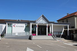 Town hall | |
 Coat of arms | |
Location of Bourg-Saint-Christophe .mw-parser-output .locmap .od{position:absolute}.mw-parser-output .locmap .id{position:absolute;line-height:0}.mw-parser-output .locmap .l0{font-size:0;position:absolute}.mw-parser-output .locmap .pv{line-height:110%;position:absolute;text-align:center}.mw-parser-output .locmap .pl{line-height:110%;position:absolute;top:-0.75em;text-align:right}.mw-parser-output .locmap .pr{line-height:110%;position:absolute;top:-0.75em;text-align:left}.mw-parser-output .locmap .pv>div{display:inline;padding:1px}.mw-parser-output .locmap .pl>div{display:inline;padding:1px;float:right}.mw-parser-output .locmap .pr>div{display:inline;padding:1px;float:left}html.skin-theme-clientpref-night .mw-parser-output .od,html.skin-theme-clientpref-night .mw-parser-output .od .pv>div,html.skin-theme-clientpref-night .mw-parser-output .od .pl>div,html.skin-theme-clientpref-night .mw-parser-output .od .pr>div{background:#fff;color:#000}html.skin-theme-clientpref-night .mw-parser-output .locmap{filter:grayscale(0.6)}@media(prefers-color-scheme:dark){html.skin-theme-clientpref-os .mw-parser-output .locmap{filter:grayscale(0.6)}html.skin-theme-clientpref-os .mw-parser-output .od,html.skin-theme-clientpref-os .mw-parser-output .od .pv>div,html.skin-theme-clientpref-os .mw-parser-output .od .pl>div,html.skin-theme-clientpref-os .mw-parser-output .od .pr>div{background:white;color:#000}}  Bourg-Saint-Christophe  Bourg-Saint-Christophe | |
| Coordinates: 45°53′28″N 5°09′42″E / 45.891032°N 5.161722°E | |
| Country | France |
| Region | Auvergne-Rhône-Alpes |
| Department | Ain |
| Arrondissement | Belley |
| Canton | Meximieux |
| Intercommunality | Plaine de l'Ain |
| Government | |
| • Mayor (2020–2026) | Bernard Perret[1] |
| Area 1 | 8.98 km2 (3.47 sq mi) |
| Population (2021)[2] | 1,517 |
| • Density | 170/km2 (440/sq mi) |
| Time zone | UTC+01:00 (CET) |
| • Summer (DST) | UTC+02:00 (CEST) |
| INSEE/Postal code | 01054 /01800 |
| Elevation | 207–305 m (679–1,001 ft) (avg. 209 m or 686 ft) |
| 1 French Land Register data, which excludes lakes, ponds, glaciers > 1 km2 (0.386 sq mi or 247 acres) and river estuaries. | |
It is located between the towns of Meximieux, Pérouges, and Béligneux.
Population edit
| Year | Pop. | ±% p.a. |
|---|---|---|
| 1968 | 507 | — |
| 1975 | 515 | +0.22% |
| 1982 | 659 | +3.59% |
| 1990 | 716 | +1.04% |
| 1999 | 824 | +1.57% |
| 2007 | 1,065 | +3.26% |
| 2012 | 1,230 | +2.92% |
| 2017 | 1,366 | +2.12% |
| Source: INSEE[3] | ||
See also edit
References edit
- ^ "Répertoire national des élus: les maires". data.gouv.fr, Plateforme ouverte des données publiques françaises (in French). 2 December 2020. Archived from the original on 28 June 2020. Retrieved 24 March 2021.
- ^ "Populations légales 2021". The National Institute of Statistics and Economic Studies. 28 December 2023.
- ^ Population en historique depuis 1968 Archived 26 July 2022 at the Wayback Machine, INSEE
External links edit
Wikimedia Commons has media related to Bourg-Saint-Christophe.
- Bourg-Saint-Christophe official website