
KNOWPIA
WELCOME TO KNOWPIA

Bouvigny-Boyeffles 
Summary
Bouvigny-Boyeffles is a commune in the Pas-de-Calais department in the Hauts-de-France region in northern France.[3]
Bouvigny-Boyeffles | |
|---|---|
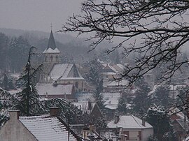 The church of Bouvigny-Boyeffles | |
 Coat of arms | |
Location of Bouvigny-Boyeffles .mw-parser-output .locmap .od{position:absolute}.mw-parser-output .locmap .id{position:absolute;line-height:0}.mw-parser-output .locmap .l0{font-size:0;position:absolute}.mw-parser-output .locmap .pv{line-height:110%;position:absolute;text-align:center}.mw-parser-output .locmap .pl{line-height:110%;position:absolute;top:-0.75em;text-align:right}.mw-parser-output .locmap .pr{line-height:110%;position:absolute;top:-0.75em;text-align:left}.mw-parser-output .locmap .pv>div{display:inline;padding:1px}.mw-parser-output .locmap .pl>div{display:inline;padding:1px;float:right}.mw-parser-output .locmap .pr>div{display:inline;padding:1px;float:left}html.skin-theme-clientpref-night .mw-parser-output .od,html.skin-theme-clientpref-night .mw-parser-output .od .pv>div,html.skin-theme-clientpref-night .mw-parser-output .od .pl>div,html.skin-theme-clientpref-night .mw-parser-output .od .pr>div{background:#000;color:#fff}html.skin-theme-clientpref-night .mw-parser-output .locmap{filter:grayscale(0.6)}@media(prefers-color-scheme:dark){html.skin-theme-clientpref-os .mw-parser-output .locmap{filter:grayscale(0.6)}html.skin-theme-clientpref-os .mw-parser-output .od,html.skin-theme-clientpref-os .mw-parser-output .od .pv>div,html.skin-theme-clientpref-os .mw-parser-output .od .pl>div,html.skin-theme-clientpref-os .mw-parser-output .od .pr>div{background:#000;color:#fff}}  Bouvigny-Boyeffles  Bouvigny-Boyeffles | |
| Coordinates: 50°25′20″N 2°40′23″E / 50.4222°N 2.6731°E | |
| Country | France |
| Region | Hauts-de-France |
| Department | Pas-de-Calais |
| Arrondissement | Lens |
| Canton | Bully-les-Mines |
| Intercommunality | CA Lens-Liévin |
| Government | |
| • Mayor (2020–2026) | Maurice Viseux[1] |
| Area 1 | 9.07 km2 (3.50 sq mi) |
| Population (2021)[2] | 2,371 |
| • Density | 260/km2 (680/sq mi) |
| Time zone | UTC+01:00 (CET) |
| • Summer (DST) | UTC+02:00 (CEST) |
| INSEE/Postal code | 62170 /62172 |
| Elevation | 68–192 m (223–630 ft) (avg. 116 m or 381 ft) |
| 1 French Land Register data, which excludes lakes, ponds, glaciers > 1 km2 (0.386 sq mi or 247 acres) and river estuaries. | |
Geography edit
An ex-coalmining area, but now a farming village, situated just 8 miles (13 km) west of Lens at the junction of the D165 and D75 roads.
Population edit
| Year | Pop. | ±% p.a. |
|---|---|---|
| 1968 | 1,927 | — |
| 1975 | 2,049 | +0.88% |
| 1982 | 2,216 | +1.13% |
| 1990 | 2,317 | +0.56% |
| 1999 | 2,439 | +0.57% |
| 2007 | 2,449 | +0.05% |
| 2012 | 2,447 | −0.02% |
| 2017 | 2,403 | −0.36% |
| Source: INSEE[4] | ||
Sights edit
- The church of St. Marin, dating from the fifteenth century.
- The modern church of St. Martin.
- The eighteenth-century chateau of Boyeffles.
- The radio and TV transmitter.
See also edit
References edit
- ^ "Répertoire national des élus: les maires". data.gouv.fr, Plateforme ouverte des données publiques françaises (in French). 2 December 2020.
- ^ "Populations légales 2021". The National Institute of Statistics and Economic Studies. 28 December 2023.
- ^ INSEE commune file
- ^ Population en historique depuis 1968, INSEE
External links edit
Wikimedia Commons has media related to Bouvigny-Boyeffles.
- Website of the Communaupole de Lens-Liévin (in French)