
KNOWPIA
WELCOME TO KNOWPIA

Bouvines 
Summary
Bouvines (French pronunciation: [buvin]; Dutch: Bovingen) is a commune and village in the Nord department in northern France.[3] It is on the French-Belgian border between Lille and Tournai.[4]
Bouvines | |
|---|---|
 The church in Bouvines | |
 Coat of arms | |
Location of Bouvines .mw-parser-output .locmap .od{position:absolute}.mw-parser-output .locmap .id{position:absolute;line-height:0}.mw-parser-output .locmap .l0{font-size:0;position:absolute}.mw-parser-output .locmap .pv{line-height:110%;position:absolute;text-align:center}.mw-parser-output .locmap .pl{line-height:110%;position:absolute;top:-0.75em;text-align:right}.mw-parser-output .locmap .pr{line-height:110%;position:absolute;top:-0.75em;text-align:left}.mw-parser-output .locmap .pv>div{display:inline;padding:1px}.mw-parser-output .locmap .pl>div{display:inline;padding:1px;float:right}.mw-parser-output .locmap .pr>div{display:inline;padding:1px;float:left}html.skin-theme-clientpref-night .mw-parser-output .od,html.skin-theme-clientpref-night .mw-parser-output .od .pv>div,html.skin-theme-clientpref-night .mw-parser-output .od .pl>div,html.skin-theme-clientpref-night .mw-parser-output .od .pr>div{background:#000;color:#fff}html.skin-theme-clientpref-night .mw-parser-output .locmap{filter:grayscale(0.6)}@media(prefers-color-scheme:dark){html.skin-theme-clientpref-os .mw-parser-output .locmap{filter:grayscale(0.6)}html.skin-theme-clientpref-os .mw-parser-output .od,html.skin-theme-clientpref-os .mw-parser-output .od .pv>div,html.skin-theme-clientpref-os .mw-parser-output .od .pl>div,html.skin-theme-clientpref-os .mw-parser-output .od .pr>div{background:#000;color:#fff}}  Bouvines  Bouvines | |
| Coordinates: 50°34′59″N 3°10′59″E / 50.583°N 3.183°E | |
| Country | France |
| Region | Hauts-de-France |
| Department | Nord |
| Arrondissement | Lille |
| Canton | Templeuve-en-Pévèle |
| Intercommunality | Métropole Européenne de Lille |
| Government | |
| • Mayor (2020–2026) | Alain Bernard[1] |
| Area 1 | 2.71 km2 (1.05 sq mi) |
| Population (2021)[2] | 755 |
| • Density | 280/km2 (720/sq mi) |
| Time zone | UTC+01:00 (CET) |
| • Summer (DST) | UTC+02:00 (CEST) |
| INSEE/Postal code | 59106 /59830 |
| 1 French Land Register data, which excludes lakes, ponds, glaciers > 1 km2 (0.386 sq mi or 247 acres) and river estuaries. | |
History edit
On 27 July 1214, the Battle of Bouvines was fought here between the forces of the French King Philip Augustus, who was resoundingly victorious, against a coalition, led by Holy Roman Emperor Otto IV and the English King John (who was not present at the battle).[4]
Population edit
| Year | Pop. | ±% p.a. |
|---|---|---|
| 1968 | 560 | — |
| 1975 | 611 | +1.25% |
| 1982 | 577 | −0.81% |
| 1990 | 683 | +2.13% |
| 1999 | 772 | +1.37% |
| 2009 | 713 | −0.79% |
| 2014 | 698 | −0.42% |
| 2020 | 746 | +1.11% |
| Source: INSEE[5] | ||
Heraldry edit
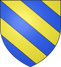 |
The arms of Bouvines are blazoned : Bendy Or and azure. (Baisieux, Bouvines and Cysoing use the same arms.)
|
Notable residents edit
- General Achille Pierre Deffontaines was born there.
See also edit
References edit
- ^ "Répertoire national des élus: les maires". data.gouv.fr, Plateforme ouverte des données publiques françaises (in French). 2 December 2020.
- ^ "Populations légales 2021". The National Institute of Statistics and Economic Studies. 28 December 2023.
- ^ INSEE commune file
- ^ a b Chisholm, Hugh, ed. (1911). . Encyclopædia Britannica (11th ed.). Cambridge University Press.
- ^ Population en historique depuis 1968, INSEE
Wikimedia Commons has media related to Bouvines.