


Summary
Boyd's Cove, also known as Boyd's Harbour, is a local service district and designated place in the Canadian province of Newfoundland and Labrador that is near Lewisporte. There is an interpretive centre dedicated to the earlier indigenous Beothuk settlement at this location.[1][2]
Boyd's Cove | |
|---|---|
Former community | |
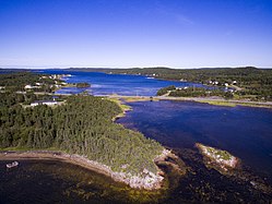 Harbour of Boyd's Cove | |
 Boyd's Cove Location of Hopewell in Newfoundland | |
| Coordinates: 49°26′36″N 54°39′27″W / 49.44333°N 54.65750°W | |
| Country | |
| Province | |
| Population (2016) | |
| • Total | 183 |
| Time zone | UTC-3:30 (Newfoundland Time) |
| • Summer (DST) | UTC-2:30 (Newfoundland Daylight) |
| Area code | 709 |


History edit
Boyd's Cove was first settled by the Beothuks in the late 18th century. During the summer months, the people lived by the cove in wigwams built over shallow excavations in the ground.[3] As well as more traditional activities, the group scavenged metal items left behind at French and English summer fishing camps, and refashioned these for their own use.[4] Although these indigenous people didn't interact with European traders as much as most native peoples, some of the Beothuk were killed by encroaching settlers,[5] and researchers have concluded that the group later died out partly because of exposure to disease and partly because of starvation, which in turn was caused both by the resulting poor health and by limited access to resources after European settlement.[6]
A settlement at Boyd's Cove was later established by the Freake, Newman and Robinson families from Fogo Island in the late 19th century. Settlers also came from the Change Islands to settle at the cove, on the mainland. At first Boyd's Cove was a logging and fishing community; later it became a producer of turnip, carrot, potato and hay in the Notre Dame Bay area. Because of its sheltered location on the shoreline, the village often hosted residents from the more exposed fishing villages in the winter.[7]
The rugged landscape and climate meant that survival there was often a struggle; with the nearest hospital in Lewisporte, NL, nearly 1½ hours away by horse in the 1920s and 1930s, medical care was often unavailable. If there was a serious illness, such as tuberculosis, residents would have to go to St. John's.
Geography edit
Boyd's Cove is in Newfoundland within Subdivision G of Division No. 8.[8] Boyd's Cove is located in the North Shore Forest ecoregion.[9] The shoreline is sheltered by nearby large islands.[10] Route 340 passes through Boyd's Cove, then crosses a causeway on the way to Twillingate.[11]
Demographics edit
As a designated place in the 2016 Census of Population conducted by Statistics Canada, Boyd's Cove recorded a population of 183 living in 90 of its 131 total private dwellings, a change of -3.7% from its 2011 population of 190. With a land area of 6.46 km2 (2.49 sq mi), it had a population density of 28.3/km2 (73.4/sq mi) in 2016.[12]
Attractions edit
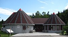
The nearby Beothuk interpretive centre hosts educational activities, book launches and ceremonies, and includes Gerald Squires' bronze statue, "The Spirit of the Beothuk".[13]
- Archaeological site
A major Beothuk archaeological site at Boyd's Cove was excavated by Dr. Ralph T. Pastore of Memorial University of Newfoundland.[14] in the early 1980s. The site is now home to the Boyd's Cove Interpretation Centre. Archaeological evidence revealed that Boyd's Cove has been occupied intermittently for about 2000 years. Beothuk pit houses dating from the late 17th or the early 18th century have yielded stone tools lying nearby European artifacts. These tools helped to establish a link between the Beothuk and their prehistoric ancestors. Faunal analysis indicated that the site was occupied at least from late winter to fall, and that the Beothuk relied on both marine and land resources for their subsistence.[15] The site was designated a National Historic Site of Canada in 1995.[16]
Government edit
Boyd's Cove is a local service district (LSD)[17] that is governed by a committee responsible for the provision of certain services to the community.[18] The chair of the LSD committee is Bruce Mercer.[17]
See also edit
References edit
- ^ Graham Gibbs (18 April 2016). Five Ages of Canada: A History From Our First Peoples to Confederation. FriesenPress. pp. 31–. ISBN 978-1-4602-8311-0.
- ^ "Voices on the Wind brings out a large crowd in Boyd’s Cove". The Pilit, Patrick Murphy Sep 29, 2017
- ^ Historical Atlas of Canada. University of Toronto Press. 1987. p. 54. ISBN 978-0-8020-2495-4.
- ^ William Moss (2 December 2017). The Recent Archaeology of the Early Modern Period in Quebec City: 2009. Taylor & Francis. pp. 79–. ISBN 978-1-351-19333-7.
- ^ "Newfoundland: Last days of Beothuk". Mitchel Smith, Toronto Sun, June 25, 2014
- ^ "Boyd's Cove: Beothuks". Heritage Newfoundland.
- ^ Robert Mellin (17 September 2008). Tilting: House Launching, Slide Hauling, Potato Trenching, and Other Tales from a Newfoundland Fishing Village. Princeton Architectural Press. p. 17. ISBN 978-1-56898-807-8.
- ^ "Population and dwelling counts, for Canada, provinces and territories, census divisions, census subdivisions (municipalities) and designated places, 2016 and 2011 censuses – 100% data (Newfoundland and Labrador)". Statistics Canada. February 7, 2018. Retrieved December 23, 2021.
- ^ Sarah L.R. Mason; Jon G. Hather (17 September 2016). Hunter-Gatherer Archaeobotany: Perspectives from the Northern Temperate Zone. Taylor & Francis. p. 56. ISBN 978-1-315-42715-7.
- ^ Fodor's Travel Guides (24 May 2016). Fodor's Nova Scotia & Atlantic Canada: with New Brunswick, Prince Edward Island, and Newfoundland. Fodor's Travel. p. 600. ISBN 978-1-101-88039-5.
- ^ Chloe Ernst (14 June 2011). Scenic Driving Atlantic Canada: Nova Scotia, New Brunswick, Prince Edward Island, Newfoundland & Labrador. Rowman & Littlefield. p. 183. ISBN 978-0-7627-6947-6.
- ^ "Population and dwelling counts, for Canada, provinces and territories, and designated places, 2016 and 2011 censuses – 100% data (Newfoundland and Labrador)". Statistics Canada. February 7, 2018. Retrieved December 22, 2021.
- ^ "From eulogies to Indigenous history: Gary Collins on becoming an author later in life". CBC News, Terri Coles Feb 17, 2018
- ^ Ingeborg Marshall (May 1998). A History and Ethnography of the Beothuk. McGill-Queen's Press - MQUP. p. 275. ISBN 978-0-7735-1774-5.
- ^ "Boyd's Cove". The Canadian Encyclopedia. Archived from the original on 2011-08-06. Retrieved 2010-10-25.
- ^ Boyd's Cove Beothuk. Canadian Register of Historic Places. Retrieved 17 June 2012.
- ^ a b "Directory of Local Service Districts" (PDF). Government of Newfoundland and Labrador. October 2021. Retrieved January 1, 2022.
- ^ "Local Service Districts – Frequently Asked Questions". Government of Newfoundland and Labrador. Retrieved January 1, 2022.
- Boyd's Cove - The Canadian Encyclopedia
External links edit
- Heritage Newfoundland
- Community information
- Travel NL