


Summary
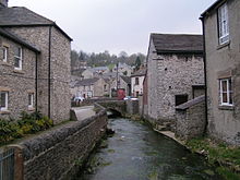
Bradwell is a village and civil parish in the Derbyshire Peak District of England. The population of the civil parish taken at the 2011 Census was 1,416.[1] It lies south of the main body of the Hope Valley but is usually included among its settlements.
| Bradwell | |
|---|---|
 | |
 Bradwell Location within Derbyshire | |
| Population | 1,416 (2011) |
| District | |
| Shire county | |
| Region | |
| Country | England |
| Sovereign state | United Kingdom |
| Post town | HOPE VALLEY |
| Postcode district | S33 |
| Dialling code | 01433 |
| Police | Derbyshire |
| Fire | Derbyshire |
| Ambulance | East Midlands |
| UK Parliament | |
Toponymy edit
The name Bradwell is thought to be a corruption of Broadwell, a reference to the Grey Ditch. Some locals cite an alternative derivation from a well at the village's centre known as Brad's Well.[2] It is unclear whether the village's name came from the well or vice versa.[3]
History edit
Pre-history edit
A Mesolithic pebble mace-head was found in Smalldale and a Mesolithic lithic working site was discovered when a site near Bradwell Moor Barn was excavated.[4][5]
A number of Neolithic axes have been found in the village.[6][7][8][9]
A Bronze Age barrow and the remains of a cist with a skeleton was found in 1891.[10] A possible Bronze Age round barrow 19 m in diameter has been found near to Minchlow Lane.[11] A Late Bronze Age socketed bronze axehead was found at a property in Hungry Lane in 1940. It is now held by Buxton Museum.[12]
Roman period edit
A few Roman remains have been found in the village, associated with the nearby Navio[13] fort near Brough-on-Noe, including a Roman bath. Coins from the reign of Vespasian[14] and Constantine the Great[15] have been discovered and a Roman pig of lead has also been found in the village.[16] The Roman road Batham Gate runs through the village.[17]
Anglo-Saxon period edit
Grey Ditch is a medieval earthwork and a Scheduled Monument. Ceramic finds and the fact that the feature overlays the Roman road Batham Gate indicate that Grey Ditch is post-Roman. No firm date has been established for the earthwork with speculation that the feature might have been designed to halt the advance of the Angels or Anglo-Saxons in the 5th to 7th centuries. Other suggestions are the Grey Ditch might have formed the boundary between the Kingdoms of Northumbria and Mercia during the Heptarchy or that it was constructed in the Viking period.[18][19]
Medieval period edit
The Domesday Book records that in 1066 Bradwell was held by Leofing, Owine of Bradwell and Sprot of Bradwell. By 1086 William Peverel is listed as both Lord and Tenant-in-chief. The population in 1086 was 8 villagers.[20]
Hazlebadge Hall, dating from 1549, is a Grade II* listed building immediately south of the village in the adjacent parish of Hazlebadge.[21]
17th century to present edit
The oldest surviving public house in Bradwell is the White Hart. It was constructed in 1676.[3]
Non-conformism was popular in Bradwell. In 1747 John Wesley preached in Towngate. In 1754 a Presbyterian chapel was built in the village. This became Unitarian at the end of the 18th century and is now used as a local scout headquarters.[22] A General Baptist chapel opened in 1790. This was used by Primitive Methodists as a Sunday school in the 20th century.[23] A Wesleyan Methodist chapel opened in 1807. It was restored and extended 1891. It is now a Methodist church.[24] A Primitive Methodist chapel was constructed in 1845, extended in 1878, and closed in 1972.[25]
Historically Bradwell was part of Hope ecclesiastical parish until 1868 when the Anglican Church of St. Barnabas opened. Samuel Fox, inventor of the Paragon umbrella frame, donated £100 towards the cost of constructing the church.[3]
The village grew again in the eighteenth century around lead mining.
Economy edit
As with many Peak District villages, Bradwell has become a settlement for commuters[26] and retirees.[27] The other sources of income are the landmark local cement factory in the adjacent parish of Hope,[28] pubs, B&Bs, an eponymous locally made ice cream,[29] and some subsidised farming. The Bagshawe Cavern former show cave is now only open by appointment.[30] In November 2017 plans to build 43 three to five-bedroomed houses for the open market and 12 two-bedroomed affordable homes to meet local needs as well as six small industrial units on a former industrial estate were announced.[31]
Culture and community edit

The village is known for its well dressing[32] and holds a carnival each year, usually in August.[33]
Bradwell has a number of green spaces including Beggars Plot Playing Field, Town Bottom Playing Field and the Rose Garden.[34]
Bradwell Surgery is open weekdays with another surgery at nearby Tideswell.[35]
Transport edit
The B6049 Bradwell to Tideswell road runs through the village. It connects with the A6187 and the A623.
The village is served by a number of bus routes. An hourly bus service runs Monday to Saturday with a two-hourly service on Sundays on the Sheffield to Castleton route, operated by First, Hulleys of Baslow and TM Travel (in 2017).[36] Four buses a day every day of the week run on the Castleton to Bakewell route, operated by Hulleys of Baslow (in 2017). One bus runs Monday to Saturday on the Baslow to Castleton route, operated by Hulleys of Baslow (in 2017).[37] One bus every day of the week runs on the Chesterfield to Buxton route, operated by Hulleys of Baslow (in 2017).[38]
The nearest railway station is at Hope on the Sheffield to Manchester (Hope Valley) line with services provided by the rail company Northern (in 2018).[39]
Education edit
Bradwell has both an Infant and Junior school, Bradwell CE Infant School and Bradwell Junior School.[40] Hope Valley College was initially supposed to be built in Bradwell but due to a last minute issue an alteration was made to the plans and it was instead built in the neighbouring village of Hope.[41]
Sport edit
Bradwell Sports Club offers facilities for football, tennis and multi sports. The club was founded in 1947.[42]
Notable residents edit
- Denis Avey, British hero of the Holocaust.
- Samuel Fox, umbrella frame designer, was born here in 1815.
Climate edit
Climate in this area has mild differences between highs and lows, and there is adequate rainfall year-round. The Köppen Climate Classification subtype for this climate is "Cfb". (Marine West Coast Climate/Oceanic climate).[43]
See also edit
References edit
- ^ "Civil Parish population 2011". Neighbourhood Statistics. Office for National Statistics. Retrieved 20 March 2016.
- ^ "Brads and Pins - The Ultimate Explanation!". Stapling and Nailing Supplies Ltd. Retrieved 18 May 2020.
- ^ a b c "Bradwell Parish Neighbourhood Plan 2015-2030" (PDF). Bradwell Village Website. 2015. p. 5. Archived from the original (PDF) on 7 January 2017. Retrieved 22 December 2017.
- ^ "Pastscape - Detailed Result: MONUMENT NO. 309589". www.pastscape.org.uk. Retrieved 21 December 2017.
- ^ "Pastscape - Detailed Result: MONUMENT NO. 1212216". www.pastscape.org.uk. Retrieved 21 December 2017.
- ^ "Pastscape - Detailed Result: MONUMENT NO. 309584". www.pastscape.org.uk. Retrieved 21 December 2017.
- ^ "Pastscape - Detailed Result: MONUMENT NO. 606487". www.pastscape.org.uk. Retrieved 21 December 2017.
- ^ "Pastscape - Detailed Result: MONUMENT NO. 309557". www.pastscape.org.uk. Retrieved 21 December 2017.
- ^ "Pastscape - Detailed Result: MONUMENT NO. 309548". www.pastscape.org.uk. Retrieved 21 December 2017.
- ^ "Pastscape - Detailed Result: MONUMENT NO. 309504". www.pastscape.org.uk. Retrieved 21 December 2017.
- ^ "Pastscape - Detailed Result: MONUMENT NO. 1507762". www.pastscape.org.uk. Retrieved 21 December 2017.
- ^ "Pastscape - Detailed Result: MONUMENT NO. 309551". www.pastscape.org.uk. Retrieved 21 December 2017.
- ^ Togodumnus (Kevan White) (27 January 2016). "Navio". roman-britain.co.uk. Archived from the original on 13 August 2016. Retrieved 20 November 2016.
- ^ "Pastscape - Detailed Result: MONUMENT NO. 309545". www.pastscape.org.uk. Retrieved 21 December 2017.
- ^ "Pastscape - Detailed Result: MONUMENT NO. 309581". www.pastscape.org.uk. Retrieved 21 December 2017.
- ^ "Pastscape - Detailed Result: MONUMENT NO. 309513". www.pastscape.org.uk. Retrieved 21 December 2017.
- ^ "Bradwell Parish Neighbourhood Plan 2015-2030" (PDF). Bradwell Village Website. p. 4. Archived from the original (PDF) on 7 January 2017. Retrieved 22 December 2017.
- ^ Historic England. "The Grey Ditch (1017662)". National Heritage List for England. Retrieved 20 November 2016.
- ^ "Pastscape - Detailed Result: GREY DITCH". www.pastscape.org.uk. Retrieved 21 December 2017.
- ^ Powell-Smith, Anna. "Bradwell | Domesday Book". opendomesday.org. Retrieved 22 December 2017.
- ^ Historic England. "Hazlebadge Hall (Grade II*) (1356169)". National Heritage List for England. Retrieved 10 April 2020.
- ^ "Pastscape - Detailed Result: MONUMENT NO. 1498328". www.pastscape.org.uk. Retrieved 23 December 2017.
- ^ "Pastscape - Detailed Result: MONUMENT NO. 1498329". www.pastscape.org.uk. Retrieved 23 December 2017.
- ^ "Pastscape - Detailed Result: MONUMENT NO. 1498330". www.pastscape.org.uk. Retrieved 23 December 2017.
- ^ "Pastscape - Detailed Result: MONUMENT NO. 1498331". www.pastscape.org.uk. Retrieved 23 December 2017.
- ^ "Bradwell Parish Neighbourhood Plan 2015-2030" (PDF). Bradwell Village Website. p. 18. Archived from the original (PDF) on 7 January 2017. Retrieved 23 December 2017.
- ^ "2001 Census Atlas of Derbyshire: Population density" (PDF). derbyshire.gov.uk. Archived from the original (PDF) on 28 December 2017. Retrieved 28 December 2017.
- ^ "Bulk Cement". Hope Construction Materials. Retrieved 20 November 2016.
- ^ "Bradwells Ice Cream". Bradwells.com. Retrieved 14 June 2013.
- ^ "Bagshawe Cavern". Hope Valley Online. Retrieved 17 September 2015.
- ^ "Local News". Bradwell Village Website. Archived from the original on 5 February 2015. Retrieved 23 December 2017.
- ^ Williams, Glyn. "Derbyshire Welldressing". Derbyshire Welldressing. Retrieved 21 December 2017.
- ^ "Bradwell Newsletters". Bradwell Village Website. Archived from the original on 18 March 2008. Retrieved 23 December 2017.
- ^ "Bradwell Parish Neighbourhood Plan 2015-2030" (PDF). Bradwell Village Website. p. 23. Archived from the original (PDF) on 7 January 2017. Retrieved 23 December 2017.
- ^ "Health". Bradwell Village Website. Archived from the original on 20 March 2008. Retrieved 23 December 2017.
- ^ "Timetable finder". www.travelsouthyorkshire.com. Retrieved 21 December 2017.
- ^ "Hulleys of Baslow - Timetables". hulleys-of-baslow.co.uk. Retrieved 21 December 2017.
- ^ "Public Transport in Derbyshire & the Peak District". www.derbysbus.info. Retrieved 21 December 2017.
- ^ "Hope (Derbyshire) Station Train Tickets, Departures and Timetables | Northern - Northern". www.northernrailway.co.uk. Retrieved 18 December 2017.
- ^ "Bradwell CE (C) Infant School - Home". www.bradwellinfantschool.co.uk. Retrieved 22 December 2017.
- ^ "Bradwell Junior School". www.schoolswire.co.uk. Archived from the original on 23 December 2017. Retrieved 22 December 2017.
- ^ Creative, Brightstar. "Bradwell Sports Club : Home". Bradwell Sports Club. Retrieved 23 December 2017.
- ^ "Climate Summary". Weatherbase.com. Retrieved 14 June 2013.
External links edit
- Cressbrook Multimedia: Bradwell
- BRADWELL Ancient and Modern. By SETH EVANS, published 1912, G4TIFF page images, plus a badly OCRed HTML attempt.
- Bradwell Village Website