


Summary
Braemar /breɪˈmɑːr/ ⓘ is a village in Aberdeenshire, Scotland, around 58 miles (93 km) west of Aberdeen in the Highlands. It is the closest significantly-sized settlement to the upper course of the River Dee, sitting at an elevation of 339 metres (1,112 ft).
Braemar
| |
|---|---|
 Braemar Location within Aberdeenshire | |
| Population | 808 (2011) (Crathie and Braemar Civil Parish)[2] |
| OS grid reference | NO150913 |
| • Edinburgh | 73 mi (117 km) |
| • London | 402 mi (647 km) |
| Council area | |
| Country | Scotland |
| Sovereign state | United Kingdom |
| Post town | BALLATER |
| Postcode district | AB35 |
| Dialling code | 013397 |
| Police | Scotland |
| Fire | Scottish |
| Ambulance | Scottish |
| UK Parliament | |
| Scottish Parliament | |
The Gaelic Bràigh Mhàrr properly refers to the area of upper Marr (as it literally means), i.e. the area of Marr to the west of Aboyne, the village itself being Castleton of Braemar (Baile a' Chaisteil in Scottish Gaelic). The village used to be known as Cinn Drochaid ('bridge end'); Baile a' Chaisteil referred to only the part of the village on the east bank of the river, the part on the west bank being known as Ach an Droighinn ('thorn field').
Geography edit
Braemar is approached from the south on the A93 from Glen Clunie and the Cairnwell Pass and from the East also on the A93 from Deeside. Braemar can be approached on foot from the west through Glen Tilt, Glen Feshie, Glen Dee (by the Lairig Ghru), and Glen Derry (by the Lairig an Laoigh). Braemar is within a one-and-a-half-hour drive of Aberdeen, Dundee, and Perth.
The village is overlooked from roughly northwest by Carn na Drochaide (818 m), from roughly northeast by Creag Choinneach (538 m), from roughly southwest by Carn na Sgliat (690 m), and from roughly southwest by Morrone (859 m).
Climate edit

Like most of the United Kingdom, Braemar experiences an oceanic climate[3] though somewhat cooler than lowland areas, verging on a subpolar oceanic climate.
Braemar is the third-coldest low-lying place in the UK after the villages of Dalwhinnie and Leadhills with an annual mean temperature of 6.8 °C (44.2 °F).[4] Braemar has twice entered the UK weather records with a low temperature of −27.2 °C (−17.0 °F), recorded on 11 February 1895 and again on 10 January 1982.[5] This record is shared with Altnaharra in the Scottish Highlands.
Braemar has an annual average of 102 days of air frost and 153 days with 1 mm or more of rainfall.[6] Snowfall can be heavy in winter and early spring, and often accumulates to depths of 30 cm (12 in) or more. 70 cm (28 in) was recorded by weather watcher Chris Booth on 9 February 2021.[7]
On 30 September 2015, Braemar had one of the largest recorded diurnal ranges of temperature in the UK, as well as recording the warmest and coldest temperatures for the UK for September 2015; the maximum temperature was 24.0 °C (75.2 °F) and the minimum was −1.3 °C (29.7 °F).[8] The next day it was again the coldest and warmest place in the UK. The minimum temperature was −2.0 °C (28.4 °F) and the maximum was a new October record for Braemar — 22.7 °C (72.9 °F). Braemar recorded −5.0 °C (23.0 °F) later that month, so for the second month in a row Braemar recorded the warmest and coldest monthly temperatures for the UK.[9] On 2 November 2015 a new record high temperature for November in Braemar was set 17.7 °C (63.9 °F).[10] On 11 February 2021 Braemar made national news after a temperature of −23.0 °C (−9.4 °F) was recorded. It was the lowest February temperature since 1955 and the UK's coldest night since 30 December 1995.[11]
| Climate data for Braemar WMO ID: 99089; coordinates 57°00′38″N 3°23′50″W / 57.01069°N 3.39727°W; elevation: 339 m (1,112 ft); 1991–2020 normals, extremes 1880–present | |||||||||||||
|---|---|---|---|---|---|---|---|---|---|---|---|---|---|
| Month | Jan | Feb | Mar | Apr | May | Jun | Jul | Aug | Sep | Oct | Nov | Dec | Year |
| Record high °C (°F) | 16.6 (61.9) |
16.1 (61.0) |
22.0 (71.6) |
24.5 (76.1) |
27.2 (81.0) |
30.0 (86.0) |
30.0 (86.0) |
30.0 (86.0) |
26.7 (80.1) |
23.8 (74.8) |
17.7 (63.9) |
14.1 (57.4) |
28.0 (82.4) |
| Mean daily maximum °C (°F) | 4.8 (40.6) |
5.2 (41.4) |
7.3 (45.1) |
10.2 (50.4) |
13.8 (56.8) |
16.2 (61.2) |
18.2 (64.8) |
17.4 (63.3) |
15.0 (59.0) |
10.9 (51.6) |
7.4 (45.3) |
5.0 (41.0) |
11.0 (51.8) |
| Daily mean °C (°F) | 1.9 (35.4) |
2.1 (35.8) |
3.6 (38.5) |
5.9 (42.6) |
8.9 (48.0) |
11.8 (53.2) |
13.6 (56.5) |
13.0 (55.4) |
10.7 (51.3) |
7.5 (45.5) |
4.3 (39.7) |
2.0 (35.6) |
7.1 (44.8) |
| Mean daily minimum °C (°F) | −1.1 (30.0) |
−1.1 (30.0) |
−0.1 (31.8) |
1.5 (34.7) |
3.9 (39.0) |
7.3 (45.1) |
9.0 (48.2) |
8.6 (47.5) |
6.5 (43.7) |
4.1 (39.4) |
1.2 (34.2) |
−1.1 (30.0) |
3.3 (37.9) |
| Record low °C (°F) | −27.2 (−17.0) |
−27.2 (−17.0) |
−21.7 (−7.1) |
−13.3 (8.1) |
−8.9 (16.0) |
−3.3 (26.1) |
−1.7 (28.9) |
−2.4 (27.7) |
−6.1 (21.0) |
−11.4 (11.5) |
−23.3 (−9.9) |
−25.8 (−14.4) |
−27.2 (−17.0) |
| Average precipitation mm (inches) | 100.9 (3.97) |
74.9 (2.95) |
66.4 (2.61) |
57.6 (2.27) |
59.2 (2.33) |
58.9 (2.32) |
70.3 (2.77) |
74.4 (2.93) |
68.9 (2.71) |
109.1 (4.30) |
101.0 (3.98) |
98.0 (3.86) |
939.4 (36.98) |
| Average precipitation days (≥ 1.0mm) | 14.3 | 13.3 | 13.2 | 11.0 | 11.8 | 11.8 | 12.4 | 11.8 | 11.4 | 15.3 | 15.6 | 15.0 | 156.8 |
| Mean monthly sunshine hours | 29.0 | 58.2 | 104.2 | 142.6 | 186.4 | 157.0 | 157.0 | 144.3 | 115.9 | 66.6 | 38.8 | 22.1 | 1,221.8 |
| Source 1: Met Office[12][13] | |||||||||||||
| Source 2: KNMI[14] | |||||||||||||
History edit
The modern village sits over the Clunie Water, a strategically important crossing on the Elsick Mounth, an ancient trackway used by Picts and Romans.[15] It is located in the upper end of the historical Earldom of Mar, literally the Braes o' Mar.[16] The Scottish Gaelic name Bràigh Mhàrr ('Upland of Mar') was originally applied to the general area; using Braemar for the village dates to around 1870.[17]
Before the 11th century, there were separate hamlets on each bank of the Clunie, Auchendryne on the west and Castleton on the east, or Bail Chasteil.[16] The names are clearly marked on the current Ordnance Survey maps, below 'Braemar'. 'Castleton' refers to Kindrochit Castle, located within the modern village, rather than Braemar Castle to the south, while Kindrochit means 'bridge end'.[16] Kindrochit (or Kindrochit-Alian) was known as Doldauha before the mid-9th century.[18]


According to legend, Malcolm III came to the area in around 1059, and built a timber bridge connecting the east and west banks. 'Kindrochit' means bridge end and the castle is assumed to have been built to protect the crossing. The ruins are considered to be largely of 14th-century origin, replacing the presumed timber-construction of the original castle.[16]
Following the accession of George I in 1714, the Earl of Mar launched the 1715 Jacobite Rising on 6 September at Braemar.[19] In 1795, a Roman Catholic chapel was built on the high-ground to the west of Auchendryne, giving the name to Chapel Brae, which was used as a school.[16]
Until the 20th century, Braemar was largely owned by one of the adjoining Mar Estates, with Auchendryne and Invercauld on one side, Castleton on the other. Allegedly, inter-estate rivalry was a factor in each having its own pub, the Fife Arms Hotel in Auchendryne, and the Invercauld Arms Hotel in Castleton, built over the mound where the Earl of Mar raised the Jacobite standard in 1715.[16]
Auchindryne (to use the spelling by Wyness) from Ach' an Droighinn ('field of the thorn') belonged to a branch of the Farquharsons until it was forfeited in the aftermath of the Jacobite rising of 1745. Later that century it was acquired by William Duff, 1st Earl Fife.
The Catholic Church in Braemar is dedicated to Saint Andrew and was built in 1839.[16] Catholicism has traditionally been strong in the Braemar area, and the bones of Saint Andrew rested in Braemar before being taken to the place now known as St Andrews.[citation needed] St Ninian's Chapel, Braemar, completed in 1898, is the Scottish Episcopal Church place of worship.
Johann von Lamont (1805–1879), the Scottish-German astronomer and astrophysicist who pioneered the study of the Earth's magnetic field was born in nearby Corriemulzie.
On 16 March 2022, the 19th-century Braemar Lodge Hotel was engulfed in a fire and explosion.[20]
Language edit
In the 1891 census, 59.2% of the population of Braemar spoke the Gaelic language "habitually"; the percentage of those actually able to speak the language (despite not having much opportunity to) would have been somewhat higher. The small crofting township of Inverey (Inbhir Èidh) was 86.3% Gaelic-speaking, most non-speakers being originally from Lower Deeside. The Gaelic spoken in the Aberdeenshire Highlands shared most features in common with the Gaelic of Strathspey and East Perthshire. The last native-speaker of the local Gaelic dialect died in 1984, though there are still surviving native-speakers of the similar Strathspey dialect. At the 2001 census, out of a total population of 839 in Crathie and Braemar Civil Parish, only 5 (0.6%) claimed to be Gaelic-speakers.[21]
Braemar Gathering edit
Known colloquially as "The Games" and originating from those believed to have been held by Malcolm III, an annual Highland games gathering is held at Braemar on the first Saturday in September and is traditionally attended by the British royal family.
In 1746, the Act of Proscription stopped all clan gatherings, but following its repeal in 1782, the old enthusiasms for such events returned.[16] In 1815, the Braemar Highland Society was created and officially constituted in 1817; the first modern-day games taking place in 1832 with cash prizes being awarded to the competitors, using the funds of the Braemar Highland Society. On 14 September 1848, Queen Victoria attended the Gathering at Invercauld. In 1866, Royal was added to Braemar Highland Society and in 1906, the Duke of Fife presented 12 acres (5 hectares) of Mar Estate to the society, and the Princess Royal and Duke of Fife Memorial Park, the current home of the Braemar Gathering, was created.
Since Queen Victoria's time, the reigning monarch has been the patron of the Braemar Royal Highland Society.
Lots of events are held including;
- Hill running.
- Heavy events.
- Light Events.
- Highland Dancing. The Highland Dancing is high quality, due to careful selection by the organisers. As the dancing boards are located right in front of the Patron's Pavilions, some of the dancers at this festival have been watched by members of the Royal Family, including their majesties themselves, Queen Elizabeth (1952-2019) and King Charles (2023- ).
Another event that happens at Braemar is the presentation of the Aberdeenshire League/Walker's Shortbread League winners. The overall top 6 dancers from across certain highland games held over the summer get presented with their awards. Each dancer receives a tin of Walker's shortbread (hence the nickname 'Shortbread League' and a commemorative vase or picture or something similar.
-
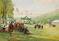 Braemar Highland Games by John Mitchell, 1898
 -
 Participants at the 2006 Games.


Amenities edit

Braemar has a golf course, two large hotels (Fife Arms and Invercauld Arms) as well as many smaller hotels and private homes offering bed and breakfast-style accommodation and a large SYHA hostel. On the southern edge of the village there is also a caravan site. Braemar also has a small post office/village shop and mountain bike hire.
The Morrone Birkwood Nature Reserve is a nature reserve on the edge of the village reached from the car park at the top of Chapel Brae.
Transportation edit
There is a regular bus service between Braemar and Aberdeen.[22]
See also edit
Notes and references edit
- ^ Ainmean-Àite na h-Alba ~ Gaelic Place-names of Scotland[permanent dead link]
- ^ "Scotland's Census".
- ^ "Braemar Climate".
- ^ "Climatalogy Maps". KNMI. Archived from the original on 19 January 2018. Retrieved 2 January 2012.
- ^ United Kingdom Meteorological Office statistics Archived 21 July 2006 at the Wayback Machine
- ^ Met Office—[1]. Retrieved 1 October 2015
- ^ "'Record' Snowfall at Braemar".
- ^ "September 2015". Met Office. 2 October 2015. Retrieved 26 February 2016.
- ^ "October 2015". Met Office. 5 November 2015. Retrieved 26 February 2016.
- ^ "Climate summaries".
- ^ "Temperature of -23C in Braemar is UK's lowest in 25 years'". BBC. 11 February 2021. Retrieved 11 February 2021.
- ^ "Braemar 1981–2010 averages". Met Office. Retrieved 4 April 2019.
- ^ "Aviemore last 24 hours weather – Met Office". Web.archive.org. 2 October 2015. Archived from the original on 2 October 2015. Retrieved 26 February 2016.
- ^ Met Office—[2]. Retrieved 7 Nov 2011.
- ^ C. Michael Hogan, Elsick Mounth, Megalithic Portal, editor: Andy Burnham (2007)
- ^ a b c d e f g h Fenton Wyness (1968). Royal Valley : The Story of the Aberdeenshire Dee. Aberdeen: Alex P. Reid & Son.
- ^ Adam Watson (1975). District Guide: The Cairngorms. Edinburgh: The Scottish Mountaineering Trust.
- ^ Ross, Alasdair. "Medieval European land assessment, Fortriu, and the dabhach" (PDF). Dspace.
- ^ Christoph v. Ehrenstein, 'Erskine, John, styled twenty-second or sixth earl of Mar and Jacobite duke of Mar (bap. 1675, d. 1732)', Oxford Dictionary of National Biography, Oxford University Press, 2004; online edn, Jan 2008, Retrieved 12 June 2019.
- ^ "Braemar Lodge Hotel evacuated after major fire and explosion". BBC News. 16 March 2022. Retrieved 22 March 2022.
- ^ Census 2001 : Knowledge of Gaelic Archived 7 March 2012 at the Wayback Machine
- ^ "Stagecoach phases in an increase in Aberdeenshire bus services". Grampian Online. 25 June 2020. Archived from the original on 5 July 2020. Retrieved 28 April 2021.
External links edit
- Braemar information guide for visitors
- Official Braemar Gathering Website