


Summary
Bramston Beach is a coastal town and rural locality in Cairns Region, Queensland, Australia.[2][3] In the 2021 census, the locality of Bramston Beach had a population of 173 people.[4]
| Bramston Beach Queensland | |||||||||||||||
|---|---|---|---|---|---|---|---|---|---|---|---|---|---|---|---|
 Bramston Beach | |||||||||||||||
 Bramston Beach | |||||||||||||||
| Coordinates | 17°21′14″S 146°01′29″E / 17.3538°S 146.0247°E | ||||||||||||||
| Population | 150 (UCL 2021)[1] | ||||||||||||||
| Postcode(s) | 4871 | ||||||||||||||
| Area | 55.6 km2 (21.5 sq mi) | ||||||||||||||
| Time zone | AEST (UTC+10:00) | ||||||||||||||
| Location |
| ||||||||||||||
| LGA(s) | Cairns Region | ||||||||||||||
| State electorate(s) | Hill | ||||||||||||||
| Federal division(s) | Kennedy | ||||||||||||||
| |||||||||||||||
Geography edit

Bramston Beach is located 60 kilometres (37 mi) south of the regional centre of Cairns. It is located 17 kilometres (11 mi) east of the Bruce Highway and is accessed from the highway via Bramston Beach Road.[5]

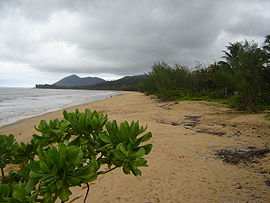
The Bramston Beach locality comprises two coastal plain areas each surrounded by small mountain ranges. The locality is bounded along the north-east by the Coral Sea and by the small mountain ranges.[5]
The northern coastal plain is partly within the Russell River National Park with the remainder used for agriculture, principally grazing. Bramston Beach Road passes through the southern part of the northern coastal plain through to the sandy beach there. The small residential and camping area is located at the end of the road by the beach.[5]
The southern coastal plain area also features a sandy beach but there are no formed roads through the area, only tracks. It is entirely freehold land used for agriculture, again principally grazing.[5]

The beach at Bramston Beach is a turtle nesting area but is suffering from natural and manmade threats to the nesting area.[6] There are also crocodiles in the area.[7]

It is a popular spot with caravaners and is a good fishing location and has a slightly older than average population.[citation needed]
History edit

The town is named after Sir John Bramston, an early politician in Queensland.[2]
In March 1872, after the wreck of The Maria on Bramble reef, one of the groups of survivors landed their raft just to the south of Cooper Point. The Djiru people in the area were exceedingly hospitable in feeding and sheltering this group until Captain John Moresby arrived in the Basilisk to return them to the British settlements further south. This group of survivors spent much of their time at a Djiru village that was located at modern day Bramston Beach. Some Djiru villages in the area consisted of quite large huts with multiple entrances. W.T. Forster, a member of this group of castaways recorded his experiences with the Djiru in a pamphlet published later on in 1872. Forster and some officials returned later to thank the Djiru and give gifts of blankets, but the village was devoid of people due to the Native Police having visited the locality the previous day.[8]
The 1996 film, The_Island_of_Dr._Moreau_(1996_film), was filmed here.[citation needed]
The 1998 film, The Thin Red Line, was partially filmed on Bramston Beach.[citation needed]
Demographics edit
In the 2006 census, the town of Bramston Beach had a population of 196 people.[9]
In the 2011 census, the locality of Bramston Beach had a population of 154 people.[10]
In the 2016 census, the locality of Bramston Beach had a population of 174 people.[11]
In the 2021 census, the locality of Bramston Beach had a population of 173 people.[4]
Education edit
There are no schools in Bramston Beach. The nearest government primary schooll is Mirriwinni State School in Mirriwinni to the south-west. The nearest government secondary school is Babinda State School (to Year 12) in Babinda to the west.[12]
References edit
- ^ Australian Bureau of Statistics (28 June 2022). "Bramston Beach (urban centre and locality)". Australian Census 2021.
- ^ a b "Bramston Beach – town (entry 4294)". Queensland Place Names. Queensland Government. Retrieved 25 June 2017.
- ^ "Bramston Beach – locality (entry 48541)". Queensland Place Names. Queensland Government. Retrieved 25 June 2017.
- ^ a b Australian Bureau of Statistics (28 June 2022). "Bramston Beach (SAL)". 2021 Census QuickStats. Retrieved 28 February 2023.
- ^ a b c d "Queensland Globe". State of Queensland. Retrieved 7 May 2018.
- ^ Constable, Russell (6 February 2009). "Threats to Marine Turtle Nests at Bramston Beach and Ella Bay" (PDF). Department of Environment and Energy. Australian Government. Retrieved 7 May 2018.
- ^ "Crocodile caught near north Queensland playground". Brisbane Times. 11 January 2017. Archived from the original on 7 May 2018. Retrieved 7 May 2018.
- ^ Forster, W. T. (1872), The wreck of the "Maria", or, Adventures of the New Guinea Prospecting Association, Printed and published by J. Reading and Co, retrieved 20 August 2017
- ^ Australian Bureau of Statistics (25 October 2007). "Bramston Beach (L) (Urban Centre/Locality)". 2006 Census QuickStats. Retrieved 27 January 2008.
- ^ Australian Bureau of Statistics (31 October 2012). "Bramston Beach (SSC)". 2011 Census QuickStats. Retrieved 7 May 2018.
- ^ Australian Bureau of Statistics (27 June 2017). "Bramston Beach (SSC)". 2016 Census QuickStats. Retrieved 20 October 2018.
- ^ "Layers: Locality; Schools and school catchments". Queensland Globe. Queensland Government. Retrieved 5 March 2024.
External links edit
- Town map of Bramston Beach, 1976
- Bramston Beach Travel.
- Bramston Beach.