
KNOWPIA
WELCOME TO KNOWPIA

Brian Head (mountain) 
Summary
Brian Head, at 11,312 feet (3,448 m) high, is the highest peak on the Markagunt Plateau and in Iron County in southwestern Utah, United States.[4] Brian Head Peak is located east of Cedar City and just north of Cedar Breaks National Monument in Dixie National Forest.[5] The town of Brian Head at the western base of the mountain is the location of the Brian Head Ski Resort.
| Brian Head | |
|---|---|
 Brian Head Peak and Cedar Breaks | |
| Highest point | |
| Elevation | 11,312 ft (3,448 m) NAVD 88[1] |
| Prominence | 3,747 ft (1,142 m)[2] |
| Listing | Utah county high points 15th[3] |
| Coordinates | 37°40′52″N 112°49′52″W / 37.681166033°N 112.831243225°W[1] |
| Geography | |
 Brian Head Location in Utah | |
| Location | Iron County, Utah, U.S. |
| Parent range | Markagunt Plateau |
| Topo map | USGS Brian Head |
Brian Head has the name of a government surveyor.[6] There is a Forest Service lookout on the peak that was built in 1934–1935, and there is also a road to the summit that can be driven in summer.[7]
-
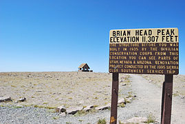 Summit
 -
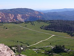 View from the summit
 -
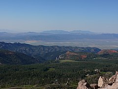 View west from the summit
 -
 Trail on the summit


See also edit
References edit
- ^ a b "Brian 2". NGS Data Sheet. National Geodetic Survey, National Oceanic and Atmospheric Administration, United States Department of Commerce. Retrieved 2016-04-15.
- ^ "Brian Head, Utah". Peakbagger.com. Retrieved 2016-04-15.
- ^ "Utah County High Points". Peakbagger.com. Retrieved 2016-04-18.
- ^ "Markagunt Plateau-Zion". Peakbagger.com. Retrieved 2012-05-27.
- ^ "Brian Head Peak". SummitPost.org. Retrieved 2012-05-27.
- ^ Leigh, Rufus Wood (1961). Five hundred Utah place names: their origin and significance. Salt Lake City: Deseret News Press. p. 8.
- ^ Staff. "Brian Head Peak Observation". Dixie National Forest, U.S. Forest Service. Retrieved 2012-05-27.
External links edit
Wikimedia Commons has media related to Brian Head (mountain).
- "Brian Head". Geographic Names Information System. United States Geological Survey, United States Department of the Interior.
- "Brian Head Peak". SummitPost.org.