


Summary
Buck Meadows (formerly Hamilton's and Hamilton's Station)[4] is a census-designated place[5] in Mariposa County, California, United States.[2] It is located 2 miles (3 km) east-northeast of Smith Peak,[4] at an elevation of 3,015 feet (919 m).[2] The population was 21 at the 2020 census.[3]
Buck Meadows | |
|---|---|
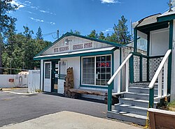 Buck Meadows General Store | |
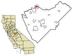 Location in Mariposa County, California | |
 Buck Meadows Location in the United States | |
| Coordinates: 37°48′46″N 120°03′52″W / 37.81278°N 120.06444°W | |
| Country | |
| State | |
| County | Mariposa |
| Area | |
| • Total | 0.535 sq mi (1.39 km2) |
| • Land | 0.535 sq mi (1.39 km2) |
| • Water | 0.00 sq mi (0.0 km2) 0% |
| Elevation | 3,015 ft (919 m) |
| Population | |
| • Total | 21 |
| Time zone | UTC-8 (Pacific) |
| • Summer (DST) | UTC-7 (PDT) |
| ZIP code | 95321 (Groveland) |
| GNIS feature IDs | 2582952, 257574 |
| FIPS code | 06-08716 |
Buck Meadows lies just south of the Tuolumne County line. It is on State Route 120, 11 miles (18 km) east of Groveland. The ZIP Code for this community is shared with Groveland (95321), and wired telephones work out of Groveland's telephone exchange with numbers following the format (209) 962-xxxx. The official U.S. Geological Survey coordinates for the community are 37°48′46″N 120°03′52″W / 37.81278°N 120.06444°W.[2]
The area is named for Buck's Meadow 37°48′43″N 120°07′07″W / 37.81194°N 120.11861°W which lies at the corner of SR120 and Smith Station Road. According to The Big Oak Flat Road, a variant name for the area was Hamilton's Station.[6] This may have referred to the name of a stagecoach stop.
2.5 miles (4.0 km) east of U.S.F.S. Buck Meadows Fire Station, "Rim of the World" overlooks the canyon containing the South Fork of the Tuolumne River.
Further east, visitors on hot summer days can cool off at a Stanislaus National Forest picnic area called "Rainbow Pool". The area is on the south side of SR120 2.25 miles east of U.S.F.S. Buck Meadows Fire Station.
This community is home to Lucky Buck Restaurant on SR120. Southwest of town, the U.S. Forest Service, Stanislaus National Forest fire lookout at Smith Peak overlooks the area. A U.S.F.S. campground and fire station are also present in the community. The Pines campground is located at 37°49′05″N 120°05′36″W / 37.81806°N 120.09333°W.
History edit
Buck Meadows started as a stage stop called Hamilton's established by Alva Hamilton in the 1870s.[4] A post office operated at Buck Meadows from 1915 to 1925.[4]
Geography edit
According to the United States Census Bureau, the CDP covers 0.535 square miles (1.386 km2), all land.[1]
Climate edit
According to the Köppen Climate Classification system, Buck Meadows has a warm-summer Mediterranean climate, abbreviated "Csa" on climate maps.[7]
Demographics edit
| Census | Pop. | Note | %± |
|---|---|---|---|
| U.S. Decennial Census[8] | |||
The 2010 United States Census[9] reported that Buck Meadows had a population of 31. The population density was 17.8 inhabitants per square mile (6.9/km2). The racial makeup of Buck Meadows was 23 (74.2%) White, 0 (0.0%) African American, 0 (0.0%) Native American, 0 (0.0%) Asian, 0 (0.0%) Pacific Islander, 5 (16.1%) from other races, and 3 (9.7%) from two or more races. Hispanic or Latino of any race were 7 persons (22.6%).
The Census reported that 31 people (100% of the population) lived in households, 0 (0%) lived in non-institutionalized group quarters, and 0 (0%) were institutionalized.
There were 15 households, out of which 2 (13.3%) had children under the age of 18 living in them, 6 (40.0%) were opposite-sex married couples living together, 0 (0%) had a female householder with no husband present, 1 (6.7%) had a male householder with no wife present. There were 0 (0%) unmarried opposite-sex partnerships, and 0 (0%) same-sex married couples or partnerships. 8 households (53.3%) were made up of individuals, and 4 (26.7%) had someone living alone who was 65 years of age or older. The average household size was 2.07. There were 7 families (46.7% of all households); the average family size was 3.29.
The population was spread out, with 7 people (22.6%) under the age of 18, 0 people (0%) aged 18 to 24, 9 people (29.0%) aged 25 to 44, 8 people (25.8%) aged 45 to 64, and 7 people (22.6%) who were 65 years of age or older. The median age was 44.5 years. For every 100 females, there were 210.0 males. For every 100 females age 18 and over, there were 200.0 males.
There were 37 housing units at an average density of 21.2 per square mile (8.2/km2), of which 4 (26.7%) were owner-occupied, and 11 (73.3%) were occupied by renters. The homeowner vacancy rate was 0%; the rental vacancy rate was 63.3%. 5 people (16.1% of the population) lived in owner-occupied housing units and 26 people (83.9%) lived in rental housing units.
Politics edit
In the state legislature Buck Meadows is located in the 14th Senate District, represented by Republican Tom Berryhill, and in the 25th Assembly District, represented by Republican Kristin Olsen.
In the United States House of Representatives, Buck Meadows is in California's 4th congressional district, represented by Democrat Mike Thompson.[10]
See also edit
References edit
- ^ a b "2021 U.S. Gazetteer Files: California". United States Census Bureau. Retrieved July 14, 2022.
- ^ a b c d U.S. Geological Survey Geographic Names Information System: Buck Meadows, California
- ^ a b "P1. Race – Buck Meadows CDP, California: 2020 DEC Redistricting Data (PL 94-171)". U.S. Census Bureau. Retrieved July 14, 2022.
- ^ a b c d Durham, David L. (1998). California's Geographic Names: A Gazetteer of Historic and Modern Names of the State. Clovis, Calif.: Word Dancer Press. ISBN 1-884995-14-4.
- ^ U.S. Geological Survey Geographic Names Information System: Buck Meadows, California
- ^ Paden, Irene and Margaret D. Schlictmann, The Big Oak Flat Road, (Oakland, California: Emil P Schlictmann, 1955).
- ^ Climate Summary for Buck Meadows, California
- ^ "Census of Population and Housing". Census.gov. Retrieved June 4, 2016.
- ^ "2010 Census Interactive Population Search: CA - Buck Meadows CDP". U.S. Census Bureau. Archived from the original on July 15, 2014. Retrieved July 12, 2014.
- ^ "California's 4th Congressional District - Representatives & District Map". Civic Impulse, LLC. Retrieved October 2, 2014.
Sources edit
- Map: "Jawbone Ridge, California," 7.5-minute quadrangle, U.S. Geological Survey.
- Map: "Stanislaus National Forest, California," U.S. Forest Service, 1979.
- U.S. Bureau of the Census