


Summary
Buleleng (Balinese: ᬓᬩᬸᬧᬢᬾᬦ᭄ᬩᬸᬮᭂᬮᭂᬂ, romanized: Kabupatén Buléléng) is a regency (kabupaten) of Bali Province, Indonesia. It stretches along the north side of the island of Bali from the Bali Strait in the west (separating Bali from East Java) almost to the eastern end of the island. It has an area of 1,365.88 km2 and a population of 624,125 at the 2010 census[2] and 791,910 at the 2020 census;[3] the official estimate as of mid-2022 was 825,141.[1] Its regency seat is in the town of Singaraja.
Buleleng Regency
Kabupaten Bulelengᬓᬩᬸᬧᬢᬾᬦ᭄ᬩᬸᬮᭂᬮᭂᬂKabupatén Buléléng | |
|---|---|
 | |
 Seal | |
| Motto: Singa Ambaraja | |
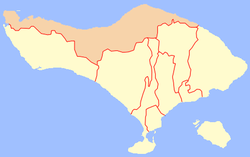 Location within Bali | |
| Country | |
| Province | |
| Capital | Singaraja |
| Government | |
| • Regent | Putu Agus Suradnyana |
| Area | |
| • Total | 527.37 sq mi (1,365.88 km2) |
| Population (mid 2022 estimate)[1] | |
| • Total | 791,810 |
| • Density | 1,500/sq mi (580/km2) |
| Time zone | UTC+8 (ICST) |
| Area code | (+62) 362 |
| Website | bulelengkab.go.id |


Buleleng was founded as a kingdom by Gusti Panji Sakti, who ruled c. 1660-c. 1700. He is commemorated as a heroic ancestor figure who expanded the power of Buleleng to Blambangan on East Java.[4] The kingdom was weakened during its successors and fell under the suzerainty of the neighbouring Karangasem kingdom in the second half of the 18th century. It was headed by an autonomous branch of the Karangasem Dynasty in 1806–1849.
The Dutch attacked Buleleng in 1846, 1848, and 1849, and defeated it on the last occasion.[5] Buleleng was incorporated into the Dutch colonial system and lost its autonomy in 1882. In 1929 a descendant of Gusti Panji Sakti, the renowned scholar Gusti Putu Jelantik, was appointed regent by the Dutch. He died in 1944, during the Japanese occupation of the Dutch East Indies. His son was a well-known novelist, Anak Agung Nyoman Panji Tisna. In 1947, Anak Agung Pandji Tisna surrendered the throne to his younger brother, Anak Agung Ngurah Ketut Djelantik, known as Meester Djelantik, until 1950. In 1949-50 Buleleng, like the rest of Bali, was incorporated into the unitary republic of Indonesia.
Administrative districts edit
The regency is divided into nine districts (kecamatan), tabulated below with their areas and population totals from the 2010 census[2] and the 2020 census,[3] together with the official estimates as of mid-2022.[1] The table also includes the number of administrative villages in each district (totaling 129 rural desa and 19 urban kelurahan), and its postal codes.
The administrative centres of each district have the same name as the district itself, except for the Buleleng District (of which the centre is Singaraja, which also serves as the administrative capital of the whole regency) and Sawan District (of which the centre is Sangsit).
| Kode Wilayah |
Name of District (kecamatan) |
Area in km2 |
Pop'n census 2010 |
Pop'n census 2020 |
Pop'n estimate mid 2022 |
No. of villages |
Post codes |
|---|---|---|---|---|---|---|---|
| 51.08.01 | Gerokgak (a) | 356.57 | 78,825 | 97,552 | 101,140 | 14 | 81155 |
| 51.08.02 | Seririt | 111.78 | 69,572 | 93,412 | 98,380 | 21 (b) | 81153 |
| 51.08.03 | Busungbiu | 196.62 | 39,719 | 52,690 | 55,360 | 15 | 81154 |
| 51.08.04 | Banjar | 172.60 | 68,960 | 86,205 | 89,540 | 17 | 81152 |
| 51.08.05 | Sukasada | 172.93 | 72,050 | 89,774 | 93,190 | 15 (b) | 81161 |
| 51.08.06 | Buleleng | 46.94 | 128,899 | 150,211 | 153,930 | 29 (c) | 81111 -81119 |
| 51.08.07 | Sawan | 92.52 | 58,578 | 80,174 | 84,760 | 14 | 81171 |
| 51.08.08 | Kubutambahan | 118.24 | 53,765 | 68,778 | 71,760 | 13 | 81172 |
| 51.08.09 | Tejakula | 97.68 | 53,757 | 73,017 | 77,080 | 10 | 81173 |
| Totals | 1,365.88 | 624,125 | 791,813 | 825,141 | 148 |
Note: (a) Gerokgak District includes the offshore island of Pulau Menjangan Kecil. (b) includes one kelurahan. (c) comprises 17 kelurahan and 12 desa.
-
 Map of Buleleng Regency in Bali
 -
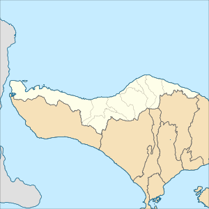 Map of districts in Buleleng Regency


List of districts and villages in Buleleng Regency as follows:
| Code | Districts | Urban villages | Rural villages | Status | List |
|---|---|---|---|---|---|
| 51.08.04 | Banjar | - | 17 | Desa |
|
| 51.08.06 | Buleleng | 17 | 12 | Desa |
|
| Kelurahan |
| ||||
| 51.08.03 | Busung Biu | - | 15 | Desa |
|
| 51.08.01 | Gerokgak | - | 14 | Desa |
|
| 51.08.08 | Kubutambahan | - | 13 | Desa |
|
| 51.08.07 | Sawan | - | 14 | Desa |
|
| 51.08.02 | Seririt | 1 | 20 | Desa |
|
| Kelurahan |
| ||||
| 51.08.05 | Sukasada | 1 | 14 | Desa |
|
| Kelurahan |
| ||||
| 51.08.09 | Tejakula | - | 10 | Desa |
|
| TOTAL | 19 | 129 |
Airports edit
Lt.Col. Wisnu Airfield is located in the Sumberkima village.
Research on a new airport was completed in 2017, due to the congestion of Ngurah Rai International Airport. The new two-runway airport will be built in the east part of Buleleng Regency and will be connected by railway to the existing airport.[6] Kubutambahan, 15 kilometers east of Singaraja, was decided to be the new airport site over two other candidates, Sangsit and Gerokgak, after taking into account geographical conditions, wind speed, wind direction, and other factors.[7]
Pearl producers edit
Many big pearl producers have developed 130.9 hectares in Gerokgak village as an area for pearl breeding and world-class pearl production. It will enlarge to 250 hectares swath of water stretching from Gerokgak to Kubutambahan.[8]
Gallery edit
-
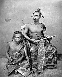
 Two warriors in Buleleng, 1865
 -
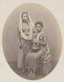 Balinese and Papuan slaves of the Rajah of Buleleng, 1865


See also edit
References edit
- ^ a b c Badan Pusat Statistik, Jakarta, 2023, Kabupaten Buleleng Dalam Angka 2023 (Katalog-BPS 1102001.5108)
- ^ a b Biro Pusat Statistik, Jakarta, 2011.
- ^ a b Badan Pusat Statistik, Jakarta, 2021.
- ^ H.J. de Graaf, 'Goesti Pandji Sakti, vorst van Boeleleng', Tijdschrift voor Indische Taal-, Land- en Volkenkunde 83:1 1949.
- ^ Pringle, pp. 96-100
- ^ "Expanded Bali airport to be at full capacity by 2017". Archived from the original on 2012-08-11. Retrieved June 23, 2012.
- ^ "Kubutambahan to become airport site". July 31, 2012. Archived from the original on 2012-08-04. Retrieved 2012-07-31.
- ^ "North Bali coast boasts major pearl producers".
External links edit
- Pringle, Robert (2004). Bali: Indonesia's Hindu Realm; A short history of. Short History of Asia Series. Allen & Unwin. ISBN 1-86508-863-3.
 North Bali travel guide from Wikivoyage
 Media related to Buleleng at Wikimedia Commons
- (in Indonesian) Official website
8°12′S 114°57′E / 8.200°S 114.950°E