


Summary
Bundoora is a suburb in Melbourne, Victoria, Australia, 15 km (9.3 mi) north-east of Melbourne's Central Business District,[2] located within the Cities of Banyule, Darebin and Whittlesea local government areas. Bundoora recorded a population of 28,068 at the 2021 census.[1]
| Bundoora Melbourne, Victoria | |||||||||||||||
|---|---|---|---|---|---|---|---|---|---|---|---|---|---|---|---|
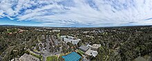
 Aerial view of Bundoora, 2017 | |||||||||||||||
 Bundoora Location in metropolitan Melbourne | |||||||||||||||
 | |||||||||||||||
| Coordinates | 37°41′42″S 145°03′50″E / 37.695°S 145.064°E | ||||||||||||||
| Population | 28,068 (2021 census)[1] | ||||||||||||||
| • Density | 1,870/km2 (4,850/sq mi) | ||||||||||||||
| Postcode(s) | 3083 | ||||||||||||||
| Area | 15 km2 (5.8 sq mi) | ||||||||||||||
| Location | 15 km (9 mi) NE of Melbourne | ||||||||||||||
| LGA(s) | |||||||||||||||
| State electorate(s) | Bundoora | ||||||||||||||
| Federal division(s) | |||||||||||||||
| |||||||||||||||
Bundoora is the headquarters of La Trobe University, Bundoora Campus. Royal Melbourne Institute of Technology (RMIT) also has a campus situated in Bundoora.
History edit
The Bundoora area was originally inhabited by the Kurnaj-berring tribe of the Wurundjeri clan. Prior to European settlement, there were several large wetlands that were utilised by members of the Kurnaj-berring tribe.[3]

Europeans first arrived in the Bundoora area, known at the time as the Parish of Keelbundora, in 1835. The land for surveyed in 1837 by William Wedge-Drake, to allow for the sale of land. The land has previously been owned by members of the Port Phillip Association, such as John Batman, who grazed their sheep there without regard for the Wurundjeri clan. The land was subsequently auctioned in Melbourne in 1838, with Bundoora being sectioned off into two areas of approximately 400 hectares. The land was purchased by well-off individuals and land speculators, who resold the land within a few months, this time in blocks of 40 to 120 hectares (100 to 300 acres). It was primarily used for sheep grazing and grain production.[3]
Bundoora Post Office opened on 1 October 1863.[4]
In 1899, John Matthew Vincent Smith, a well known horse breeder, purchased a 242-hectare (600-acre) property known as "Bundoora Park". The property was used to raise racing horses. A competition was held in the same year to design a homestead for the property. Sydney Herbert Wilson, who designed the Malvern Town Hall, claimed the prize of 50 pounds. The Bundoora Homestead[5] remains a significant example of Queen Anne style Federation architecture.[6]
The Floridia Cheese Company was formed in 1955 by the Montalto family, after purchasing a small factory in Bundoora.[7]
Geography edit


Bundoora is a very large suburb, spanning from Preston in its south-west, up to Plenty in the north-east, and covering three local government areas. Bundoora is home to Mount Cooper, located within Bundoora Park, a large (180ha) public park, and is often claimed to be Metropolitan Melbourne's highest point.
Bundoora is situated on the traditional lands of the Wurundjeri people, and the name "Bundoora" is derived from "Kelbundoora", the name of a 19th-century Wurundjeri man.[8]
Demographics edit
In the 2016 census, there were 28,653 people in Bundoora.
- The most common ancestries in Bundoora were English 14.8%, Australian 14.2%, Chinese 12.4%, Italian 9.6% and Irish 5.5%.
- 54.3% of people were born in Australia. The next most common countries of birth were China 10.2%, India 3.4%, Italy 2.3%, Greece 2.0% and Sri Lanka 1.9%.
- 50.2% of people spoke only English at home. Other languages spoken at home included Mandarin 11.0%, Italian 4.1%, Greek 3.7%, Macedonian 3.3% and Arabic 3.1%.
- The most common responses for religion were Catholic 27.1%, No Religion 27.0% and Eastern Orthodox 9.3%.[9]
Local sites edit

- Big Daddys, a well-known pizza establishment, originated in Bundoora, and was the protagonist in the Melbourne $5 Pizza Wars of the early 2000s.[citation needed] It has now been bought-out by the Pizza franchise Domino's.
- Although, technically in Thomastown, the Bundoora All-Weather Market was until recently a major Melbourne market. This market has been demolished and replaced by a homemaker centre.
- Greensborough Lanes is a bowling alley that, despite its name, is located in Bundoora.
- University Hill is a business park home to the Australian Headquarters of Continental AG, NOVA iT GROUP and Bundoora BMW with many others, and a Hotel to serve visitors to the area.
- Uni Hill Factory Outlets, a DFO-style discount shopping mall, was opened at University Hill in November 2008. It was originally known as Brand Junction.[citation needed]
Education edit

- La Trobe University, established in 1964, is Victoria's third university, with Bundoora being the location of its flagship campus.
- RMIT University's Bundoora West Campus is located at the terminus of the tramline. Further down the road is the East Campus area, home of RMIT's Wind Tunnel.[10] It is also home of the RMIT University Sports Statistics Research Group.
- Bundoora Secondary College is a coeducational public secondary school.
- Parade College is a Catholic independent secondary school for boys .
- Loyola College is a Catholic independent secondary school in the Ignatian tradition, bordering Bundoora and Watsonia.
- The Concord School, for students with additional learning needs.
- Northside Christian College
- Norris Bank Primary School
- Bundoora Primary School is Victorian school no.1915, currently located at Balmoral Avenue, Bundoora.[11][12] The original school was built in 1877 and located at 222 Plenty Road, Bundoora.[13] This building is now the home of Nino Child Care Centre.[14]
- St Damian's Catholic Primary School
Healthcare edit
- Northpark Private Hospital
- Bundoora Extended Care Centre, part of the Northern Health Network. A sub acute hospital providing medical care for over 100 inpatients and community outpatients.
- La Trobe Private Hospital
Transport edit
Bus edit
Fifteen bus routes service Bundoora:
- 250 : Melbourne CBD (Queen Street) – La Trobe University. Operated by Kinetic Melbourne.[15]
- 301 : Reservoir station – La Trobe University. Operated by Dysons.[16]
- 350 : Queen Street (Melbourne CBD) – La Trobe University via the Eastern Freeway. Operated by Kinetic Melbourne.[17]
- 382 : Whittlesea – Northland Shopping Centre via South Morang station. Operated by Dysons.[18]
- 383 : Mill Park Lakes Palisades Estate – University Hill. Operated by Dysons.[19]
- 386 : Mernda station – RMIT University Bundoora Campus via Cravens Rd and South Morang station. Operated by Dysons.[20]
- 387 : Mernda station – RMIT University Bundoora Campus via Hawkstowe Pde and South Morang. Operated by Dysons.[21]
- 548 : Kew (Cotham Road) – La Trobe University. Operated by Ventura Bus Lines.[22]
- 550 : Northland Shopping Centre – La Trobe University via Waterdale Road. Operated by Ventura Bus Lines.[23]
- 551 : Heidelberg station – La Trobe University. Operated by Ventura Bus Lines.[24]
- 561 : Macleod – Pascoe Vale station via La Trobe University. Operated by Dysons.[25]
- 564 : RMIT University Bundoora Campus – South Morang station. Operated by Dysons.[26]
- 566 : Lalor – Northland Shopping Centre via Childs Road, Plenty Road and Grimshaw Street. Operated by Dysons.[27]
- 570 : Thomastown station – RMIT University Bundoora Campus. Operated by Dysons.[28]
- SmartBus 902 : Chelsea station – Westfield Airport West. Operated by Kinetic Melbourne.[29]
Cycling edit
The Western Ring Road Trail and Darebin Creek Trail provides facilities for recreational and commuting cyclists.
Train edit
The nearest railway stations to Bundoora are Macleod and Watsonia, on the Hurstbridge line, and South Morang, Thomastown, Keon Park and Reservoir, on the Mernda line.
Tram edit
Bundoora is the terminus of tram route ![]() , which operates from McKimmies Road near RMIT University, to Waterfront City in Docklands.[30] The line was extended from Tyler Street in Preston to the intersection of Plenty Road, Dunne Street and Kingsbury Drive in 1983, extended to Settlement Road in 1987 and extended to McKimmies Road in 1995.[31] The last W2 class tram ran along this route in mid-1987.
, which operates from McKimmies Road near RMIT University, to Waterfront City in Docklands.[30] The line was extended from Tyler Street in Preston to the intersection of Plenty Road, Dunne Street and Kingsbury Drive in 1983, extended to Settlement Road in 1987 and extended to McKimmies Road in 1995.[31] The last W2 class tram ran along this route in mid-1987.
Sport edit
- Bundoora has a football team competing in the Northern Football League.[32]
- Golfers play at the Bundoora Park Public Course on Plenty Road,[33] at the course of the Strathallan Golf Club on Main Drive[34] or at the course of the Kings Park Golf Club on Plenty Road.[35]
- Bundoora is also home to the Bundoora Brumbies Baseball Club, with the club competing in the Melbourne Winter Baseball League in B and D grade division, with reserves teams in both B reserve and D reserve. The club also has a Women's team that competes in the Baseball Victoria Summer League Women's section.
- The Home of the Matildas, the administrative and training headquarters of the Australia women's national football team and A-League Women club Melbourne Victory FC is located in Bundoora, adjacent to the La Trobe University main campus.
- The Victorian Rugby Centre of Excellence, which serves as the home ground of Melbourne Rebels Women and where Rugby Victoria's administration, sport development programs and high-performance training is based, is located in Bundoora, adjacent to the La Trobe University main campus.
Facilities edit
Nearby libraries include Watsonia Library, Diamond Valley Library and Mill Park Library, which are operated by Yarra Plenty Regional Library.
Notable residents edit
- Clinton McKay – Australian cricketer
- Gotye – an Australian musician who studied at Parade College.
- Pseudo Echo – a pop music band
- Peter Helliar – comedian
- James Wharton – an Australian racing driver
Books on Bundoora edit
Kenna, Len In the Beginning there was only the land Bundoora, Vic. Lions Club of Bundoora, 1988 ISBN 0731623177
See also edit
- City of Preston – Parts of Bundoora were previously within this former local government area.
- Shire of Diamond Valley – Parts of Bundoora were previously within this former local government area.
- Electoral district of Bundoora
References edit
- ^ a b Australian Bureau of Statistics (28 June 2022). "Bundoora (Vic.) (Suburbs and Localities)". 2021 Census QuickStats. Retrieved 1 July 2022.
- ^ "Postcode for Bundoora, Victoria (Near Melbourne) - Postcodes Australia".
- ^ a b La Trobe University, 'History of the area', La Trobe Wildlife Sanctuary [website], <http://www.latrobe.edu.au/wildlife/about/history>, accessed 29 Oct. 2015.
- ^ Phoenix Auctions History, Post Office List, retrieved 27 January 2021
- ^ "Bundoora Park Homestead". Victorian Heritage Database. 5 May 1999. Retrieved 25 May 2020.
- ^ Darebin Heritage, 'Bundoora Homestead', Darebin Heritage [website], <http://heritage.darebinlibraries.vic.gov.au/article/282> Archived 29 February 2016 at the Wayback Machine, accessed 29 Oct. 2015.
- ^ "Floridia Cheese About Us". Florida Cheese. 2018. Retrieved 22 May 2019.
- ^ http://www.darebin.vic.gov.au/Files/language_aboriginal.PDF [bare URL PDF]
- ^ Australian Bureau of Statistics (27 June 2017). "Bundoora (State Suburb)". 2016 Census QuickStats. Retrieved 3 July 2017.
- ^ "Aussie teams look to tunnel vision to blow away world's best | ATN Solar Car Team". atnsolarcar.com.au. Retrieved 25 May 2020.
- ^ "Contact". Bundoora Primary School. Retrieved 25 May 2020.
- ^ "School profile Bundoora Primary School". My School. Retrieved 25 May 2020.
- ^ "Bundoora Primary School No.1915". Victorian Heritage Database. Retrieved 25 May 2020.
- ^ "Bundoora Child Care at Nino Early Learning Adventures". Child Care at Nino Early Learning Adventures. Retrieved 25 May 2020.
- ^ "250 City (Queen St) - La Trobe University". Public Transport Victoria.
- ^ "301 Reservoir Station - La Trobe University (Bundoora Campus)". Public Transport Victoria.
- ^ "350 City - La Trobe University via Eastern Fwy". Public Transport Victoria.
- ^ "382 Whittlesea - Northland SC via South Morang Station". Public Transport Victoria.
- ^ "383 Palisades - University Hill". Public Transport Victoria.
- ^ "386 Mernda Station - Bundoora RMIT via South Morang". Public Transport Victoria.
- ^ "387 Mernda Station - Bundoora RMIT via Hawkstowe Pde & South Morang". Public Transport Victoria.
- ^ "548 Kew (Cotham Road) - La Trobe University Bundoora". Public Transport Victoria.
- ^ "550 Northland - La Trobe University via Waterdale Road". Public Transport Victoria.
- ^ "551 Heidelberg - La Trobe University Interchange". Public Transport Victoria.
- ^ "561 Macleod - Pascoe Vale via La Trobe University". Public Transport Victoria.
- ^ "564 Bundoora RMIT - South Morang". Public Transport Victoria.
- ^ "566 Lalor - Northland via Plenty Road & Childs Road & Grimshaw Street". Public Transport Victoria.
- ^ "570 Thomastown - RMIT Bundoora". Public Transport Victoria.
- ^ "902 Chelsea - Airport West (SMARTBUS Service)". Public Transport Victoria.
- ^ "86 Bundoora RMIT - Waterfront City Docklands". Public Transport Victoria.
- ^ "Bundoora", Victorian Places, retrieved 31 July 2022
- ^ Full Points Footy, Bundoora, archived from the original on 13 August 2009, retrieved 15 April 2009
- ^ Golf Select, Bundoora Park, retrieved 11 May 2009
- ^ Golf Select, Strathallan, retrieved 11 May 2009
- ^ Golf Select, Kings Park, retrieved 11 May 2009
- Australias First Microsoft Centre
- Bundora Homestead History
External links edit
- Australian Places – Bundoora