


Summary
Burgersdorp is a medium-sized town in Walter Sisulu in the Joe Gqabi District Municipality of the Eastern Cape province of South Africa.
Burgersdorp | |
|---|---|
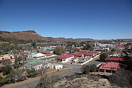
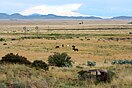
Top: Burgersdorp viewed from The Sentinel blockhouse, Middle left: Dutch Language Monument, Middle Right: NG Church, Bottom left: The Sentinel Blockhouse, Bottom right: A farm near Burgersdorp | |
 Burgersdorp  Burgersdorp  Burgersdorp | |
| Coordinates: 30°59′32″S 26°19′29″E / 30.99222°S 26.32472°E | |
| Country | South Africa |
| Province | Eastern Cape |
| District | Joe Gqabi |
| Municipality | Walter Sisulu |
| Established | 1846[1] |
| Government | |
| • Type | Local Municipality |
| • Mayor | Ncedo Ngoqo (ANC) |
| Area | |
| • Total | 27.9 km2 (10.8 sq mi) |
| Elevation | 1,405 m (4,610 ft) |
| Population (2011)[2] | |
| • Total | 5,241 |
| • Density | 190/km2 (490/sq mi) |
| Racial makeup (2011) | |
| • Black African | 39.6% |
| • Coloured | 31.0% |
| • Indian/Asian | 0.7% |
| • White | 28.7% |
| • Other | 0.0% |
| First languages (2011) | |
| • Afrikaans | 62.9% |
| • Xhosa | 30.0% |
| • English | 2.9% |
| • Sotho | 1.7% |
| • Other | 2.5% |
| Time zone | UTC+2 (SAST) |
| Postal code (street) | 9744 |
| PO box | 9744 |
| Area code | 051 |


In 1869 a Theological Seminary was established here by the Gereformeerde Kerk, but in 1905 it was moved to Potchefstroom, acting as an instrument in the formation of the PUK in 1919, then becoming the Potchefstroom University for Christian Higher Education in 1951.
The Afrikaner Bond political party was founded in Burgersdorp in 1881.[3]
Demographics edit
According to the 2011 census, the town of Burgersdorp proper has a population of 5,240,[4] while the adjacent townships of Mzamomhle and Tembisa have populations of 4,656 and 6,094 respectively,[5][6] giving the urban area a population of 15,990. Of this population 78.1% described themselves as Black African, 11.98% as Coloured and 9.4% as White. 69.2% spoke Xhosa as their home language, 20.1% spoke Afrikaans, 3.3% spoke Sotho, 1.4% spoke English as their home language and 6.0% spoke some other language.
Transport edit
Rail edit
The first rail connection to Burgersdorp was opened on 19 March 1885.[7] Today Shosholoza Meyl provides passenger rail service to Burgersdorp on its Johannesburg-Bloemfontein-East London route.[8]
Road edit
Burgersdorp is located on the junction of the R58 between Aliwal North and Venterstad; and the R391 leading to Hofmeyr, Molteno and Steynsburg.
Society edit
Sport edit
Match 18 of the 1910 British Lions tour to South Africa was played in Burgersdorp.
Museums, monuments and memorials edit
Ten of the Eastern Cape's provincial heritage sites can be found in Burgersdorp. They include the Christ Church,[9] the Coetzee House,[10] the De Bruin House,[11] the Jubilee Fountain,[12] the Old Goal,[13] the Old Reformed Church Parsonage,[14] the Old Reformed Church Theological Seminary[15] as well as the three listed below in more detail.
Dutch Reformed Church edit
This church was declared a provincial heritage site in 1996.[16]
Blockhouse edit

A Second Boer War blockhouse overlooking the town, commonly known as the Sentinel was declared a provincial heritage site in 1939.[17]
Dutch Language Monument edit
A monument to Dutch, built in 1893 is located in the town. The monument depicts a woman pointing her finger at a book in her hands. This monument was declared a provincial heritage site in 1937.[18]
Although the main inscription on that monument refers to the Hollandse taal (Dutch language), it can be understood to mean Afrikaans, because the Hollandse taal in South Africa was only split since 1925. But the monument is officially recognised as a monument to Dutch.
The monument was damaged during the Anglo-Boer War, and Lord Milner had it removed. It was replaced with a replica in 1907. The original was later discovered in King William's Town in 1939, and moved back to stand next to the replica in Burgersdorp.[19]
Some sources claim that Lord Milner had removed the original monument not because it was damaged, but because he was opposed to Dutch (and Afrikaans), and that the replica was built not by government but by a group of Afrikaners.[20]
-
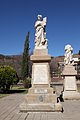 The replica (left) and original (right) Dutch Language Monuments
 -
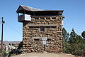 The Sentinel Blockhouse
 -
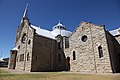 The Dutch Reformed Church


Education edit
Burgersdorp has 5 primary schools and 2 high schools
- PRIMARY SCHOOLS*
Mzimkhulu Primary School
Mpumelelo Mfundisi Public Primary School
Maruping Primary School
Eureka Primary School
Burgersdorp Laerskool
- HIGH SCHOOLS*
Ethembeni Senior Secondary School
Burgersdorp Hoerskool
References edit
- ^ Robson, Linda Gillian (2011). "Annexure A" (PDF). The Royal Engineers and settlement planning in the Cape Colony 1806–1872: Approach, methodology and impact (PhD thesis). University of Pretoria. pp. xlv–lii. hdl:2263/26503.
- ^ a b c d Main Place Burgersdorp from Census 2011.
- ^ Steevens, George Warrington; Blackburn, Vernon (1900). From Capetown to Ladysmith; an unfinished record of the South African war. New York: Dodd, Mead and Company. p. 25. Retrieved 24 November 2009.
- ^ "Main Place 'Burgersdorp'". Census 2011.
- ^ "Main Place 'Mzamomhle'". Census 2011.
- ^ "Main Place 'Tembisa'". Census 2011.
- ^ Theal, George McCall (1919). History of South Africa, from 1873 to 1884, twelve eventful years, with continuation of the history of Galekaland, Tembuland, Pondoland, and Bethshuanaland until the annexation of those territories to the Cape Colony, and of Zululand until its annexation to Natal. London: Allen. pp. 194, 287. Retrieved 24 November 2009.
- ^ "Johannesburg-Bloemfontein-East London". Shosholoza Meyl. Archived from the original on 1 November 2009. Retrieved 24 November 2009.
- ^ "Christ Church Church Street Burgersdorp". South African Heritage Resources Agency. Archived from the original on 4 July 2011. Retrieved 24 November 2009.
- ^ "Coetzee House 51 Piet Retief Street Burgersdorp". South African Heritage Resources Agency. Archived from the original on 4 July 2011. Retrieved 24 November 2009.
- ^ "De Bruin House 66 Van der Walt Street Burgersdorp". South African Heritage Resources Agency. Archived from the original on 4 July 2011. Retrieved 24 November 2009.
- ^ "Jubilee Fountain Burger Square Burgersdorp". South African Heritage Resources Agency. Archived from the original on 4 July 2011. Retrieved 24 November 2009.
- ^ "Old Gaol Van der Walt Street Burgersdorp". South African Heritage Resources Agency. Archived from the original on 4 July 2011. Retrieved 24 November 2009.
- ^ "Old Reformed Church Parsonage Piet Retief Street Burgersdorp". South African Heritage Resources Agency. Archived from the original on 19 February 2012. Retrieved 24 November 2009.
- ^ "Old Reformed Church Theological Seminary Burgersdorp". South African Heritage Resources Agency. Archived from the original on 4 July 2011. Retrieved 24 November 2009.
- ^ "Dutch Reformed Church Coetzee Street". South African Heritage Resources Agency. Archived from the original on 4 July 2011. Retrieved 24 November 2009.
- ^ "Anglo-Boer War Blockhouse No. 1 Burgersdorp". South African Heritage Resources Agency. Archived from the original on 4 July 2011. Retrieved 24 November 2009.
- ^ "Taal Monument Burger Square Burgersdorp". South African Heritage Resources Agency. Archived from the original on 19 February 2012. Retrieved 24 November 2009.
- ^ "Burgersdorp". Archived from the original on 21 April 2021. Retrieved 22 November 2009.
- ^ http://www.dieafrikaansepatriot.co.za/phpbb/phpbb2/viewtopic.php?t=56&sid=3370195c4f8c4de374ca82619d6f2083. Retrieved 22 November 2009.
{{cite web}}: Missing or empty|title=(help)[dead link]
External links edit
- Hoërskool Burgersdorp
- Laerskool Burgersdorp
- Burgersdorp.za.net
- Name of Burgersdorp, Dictionary of Southern African Place Names, Raper P.E., 1987