


Summary
Bushmanland (Afrikaans: Boesmanland) was a bantustan in South West Africa (present-day Namibia), intended by the apartheid government to be a self-governing homeland for the San people (the Bushmen).
Bushmanland Boesmanland Buschmannland | |||||||||
|---|---|---|---|---|---|---|---|---|---|
| 1976–1989 | |||||||||
 Flag | |||||||||
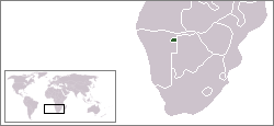 Location of Bushmanland (green) within South West Africa (grey). | |||||||||
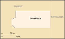 Map of the bantustan. | |||||||||
| Status | Bantustan | ||||||||
| Capital | Tsumkwe (Tjumǃkui) | ||||||||
| Common languages | Khoisan English Afrikaans German | ||||||||
| History | |||||||||
• Establishment | 1976 | ||||||||
• Re-integrated into Namibia | May 1989 | ||||||||
| Currency | South African rand | ||||||||
| |||||||||

Administrative history edit
Bushmanland was established by the South African authorities with the issue of Proclamation 208 in 1976.[1]
No government or second-tier authority was established for the San Bushmen as it was believed that "they had evinced no interest in having a governing authority".[2] Instead a Bushman Advisory Council was established in 1986.[3]
Bushmanland, like other homelands in South West Africa, was replaced by a system of non-geographic ethnic-based administrations in 1980, which were in turn abolished in May 1989 at the start of the transition to independence.
See also edit
References edit
- ^ Welch, Cameron (2018). The San and the N‡a Jaqna Conservancy, Tsumkwe District West, Namibia: The San and the N‡a Jaqna Conservancy, Tsumkwe District West, Namibia. African Books Collective. p. 28. ISBN 978-3906927039.
- ^ A Survey of Race Relations in South Africa 1980. South African Institute of Race Relations. 1981. p. 648.
- ^ "Namibian Homelands".
19°35′S 20°31′E / 19.583°S 20.517°E