


Summary
Cambrai is a small town located on the eastern side of the Mount Lofty Ranges, along the River Marne. Originally named Rhine Villa, it was one of many Australian towns renamed during World War I to remove any connection with German place names and named after the Battle of Cambrai.
| Cambrai South Australia | |||||||||||||||
|---|---|---|---|---|---|---|---|---|---|---|---|---|---|---|---|
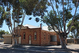 Institute | |||||||||||||||
 Cambrai | |||||||||||||||
| Coordinates | 34°39′20″S 139°16′49″E / 34.655515°S 139.280207°E[1] | ||||||||||||||
| Population | 289 (2016 census)[2] | ||||||||||||||
| Postcode(s) | 5353[3] | ||||||||||||||
| Time zone | ACST (UTC+9:30) | ||||||||||||||
| • Summer (DST) | ACST (UTC+10:30) | ||||||||||||||
| Location | 70 km (43 mi) from Adelaide | ||||||||||||||
| LGA(s) | Mid Murray Council | ||||||||||||||
| Region | Murray and Mallee[1] | ||||||||||||||
| County | Sturt[1] | ||||||||||||||
| State electorate(s) | Schubert | ||||||||||||||
| Federal division(s) | Barker | ||||||||||||||
| |||||||||||||||
| |||||||||||||||
| Footnotes | Adjoining localities[1] | ||||||||||||||
It was located on the Sedan railway line. It served as the terminus of the line from 1964 until the 1980s.[5][6]
The bounded locality of Cambrai includes the former unbounded locality of Rheinthal, which was approximately 3 km north of the town of Cambrai. It had a Lutheran church and school. The school was closed from 1916 (when all German schools were closed) until 1935, and closed permanently from 1955.[7] It also includes the Marne Valley Conservation Park and the locality of Kongolia (previously Rhine Park) to the east of the town.
References edit
- ^ a b c d "Search results for 'Cambrai, LOCB' with the following datasets selected – 'Suburbs and localities', 'Counties', 'Government Towns', 'Hundreds', 'Local Government Areas', 'SA Government Regions' and 'Gazetteer'". Location SA Map Viewer. South Australian Government. Retrieved 23 August 2019.
- ^ Australian Bureau of Statistics (27 June 2017). "Cambrai (State Suburb)". 2016 Census QuickStats. Retrieved 23 August 2019.
- ^ "Postcode for Cambrai, South Australia". Postcodes Australia. Retrieved 23 August 2019.
- ^ a b c "Monthly climate statistics: Summary statistics MOUNT CRAWFORD FOREST HEADQUARTERS (nearest weather station)". Commonwealth of Australia , Bureau of Meteorology. Retrieved 23 August 2019.
- ^ Sedan Archived 2 April 2015 at the Wayback Machine South Australian History
- ^ Port Augusta track extension project Pichi Richi Railway
- ^ "Placename Details: Rheinthal Lutheran School". Property Location Browser. Government of South Australia. 30 August 2006. SA0056525. Archived from the original on 12 October 2016. Retrieved 2 April 2016.
External links edit
![]() Media related to Cambrai, South Australia at Wikimedia Commons
Media related to Cambrai, South Australia at Wikimedia Commons