
KNOWPIA
WELCOME TO KNOWPIA

Camou-Cihigue 
Summary
Camou-Cihigue (French pronunciation: [kamu si.iɡ]; Basque: Gamere-Zihiga)[3] is a commune in the Pyrénées-Atlantiques department in south-western France.[4]
Camou-Cihigue
Gamere-Zihiga | |
|---|---|
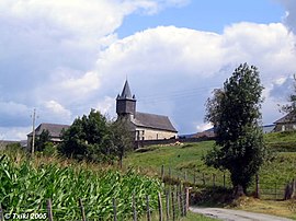 Church of Cihigue | |
Location of Camou-Cihigue .mw-parser-output .locmap .od{position:absolute}.mw-parser-output .locmap .id{position:absolute;line-height:0}.mw-parser-output .locmap .l0{font-size:0;position:absolute}.mw-parser-output .locmap .pv{line-height:110%;position:absolute;text-align:center}.mw-parser-output .locmap .pl{line-height:110%;position:absolute;top:-0.75em;text-align:right}.mw-parser-output .locmap .pr{line-height:110%;position:absolute;top:-0.75em;text-align:left}.mw-parser-output .locmap .pv>div{display:inline;padding:1px}.mw-parser-output .locmap .pl>div{display:inline;padding:1px;float:right}.mw-parser-output .locmap .pr>div{display:inline;padding:1px;float:left}html.skin-theme-clientpref-night .mw-parser-output .od,html.skin-theme-clientpref-night .mw-parser-output .od .pv>div,html.skin-theme-clientpref-night .mw-parser-output .od .pl>div,html.skin-theme-clientpref-night .mw-parser-output .od .pr>div{background:#000;color:#fff}html.skin-theme-clientpref-night .mw-parser-output .locmap{filter:grayscale(0.6)}@media(prefers-color-scheme:dark){html.skin-theme-clientpref-os .mw-parser-output .locmap{filter:grayscale(0.6)}html.skin-theme-clientpref-os .mw-parser-output .od,html.skin-theme-clientpref-os .mw-parser-output .od .pv>div,html.skin-theme-clientpref-os .mw-parser-output .od .pl>div,html.skin-theme-clientpref-os .mw-parser-output .od .pr>div{background:#000;color:#fff}}  Camou-Cihigue  Camou-Cihigue | |
| Coordinates: 43°07′02″N 0°54′17″W / 43.1172°N 0.9047°W | |
| Country | France |
| Region | Nouvelle-Aquitaine |
| Department | Pyrénées-Atlantiques |
| Arrondissement | Oloron-Sainte-Marie |
| Canton | Montagne Basque |
| Intercommunality | CA Pays Basque |
| Government | |
| • Mayor (2020–2026) | Charles Anicet Leurgorry[1] |
| Area 1 | 10.08 km2 (3.89 sq mi) |
| Population (2021)[2] | 103 |
| • Density | 10/km2 (26/sq mi) |
| Time zone | UTC+01:00 (CET) |
| • Summer (DST) | UTC+02:00 (CEST) |
| INSEE/Postal code | 64162 /64470 |
| Elevation | 208–1,009 m (682–3,310 ft) (avg. 263 m or 863 ft) |
| 1 French Land Register data, which excludes lakes, ponds, glaciers > 1 km2 (0.386 sq mi or 247 acres) and river estuaries. | |
It is located in the former province of Soule.[3]
Geography edit
Neughboring communes:
- Ossas-Suhare, in the north
- Aussurucq, in the north-west
- Alos-Sibas-Abense, in the east
- Alçay-Alçabéhéty-Sunharette, in the south
History edit
The commune of Camou-Cihigue was formed in 1836, from the merger of the former communes of Camou and Cihigue.
See also edit
References edit
- ^ "Répertoire national des élus: les maires" (in French). data.gouv.fr, Plateforme ouverte des données publiques françaises. 13 September 2022.
- ^ "Populations légales 2021". The National Institute of Statistics and Economic Studies. 28 December 2023.
- ^ a b GAMERE-ZIHIGA, Auñamendi Eusko Entziklopedia (in Spanish)
- ^ INSEE commune file
Wikimedia Commons has media related to Camou-Cihigue.