
KNOWPIA
WELCOME TO KNOWPIA

Campiglia dei Berici 
Summary
Campiglia dei Berici is a town in the province of Vicenza, Veneto, Italy. It is west of SP247 provincial road. It originated in the Middle Ages around a castle, destroyed in the 1310s. Sights include a parish church (13th century, rebuilt in 1679) and Villa Repeta-Mocenigo-Bressan, built in 1672 above the ruins of a villa by Andrea Palladio.
Campiglia dei Berici | |
|---|---|
| Comune di Campiglia dei Berici | |
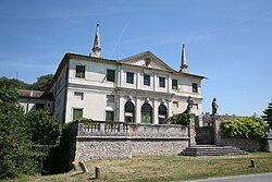 Villa Repeta | |
Location of Campiglia dei Berici .mw-parser-output .locmap .od{position:absolute}.mw-parser-output .locmap .id{position:absolute;line-height:0}.mw-parser-output .locmap .l0{font-size:0;position:absolute}.mw-parser-output .locmap .pv{line-height:110%;position:absolute;text-align:center}.mw-parser-output .locmap .pl{line-height:110%;position:absolute;top:-0.75em;text-align:right}.mw-parser-output .locmap .pr{line-height:110%;position:absolute;top:-0.75em;text-align:left}.mw-parser-output .locmap .pv>div{display:inline;padding:1px}.mw-parser-output .locmap .pl>div{display:inline;padding:1px;float:right}.mw-parser-output .locmap .pr>div{display:inline;padding:1px;float:left}html.skin-theme-clientpref-night .mw-parser-output .od,html.skin-theme-clientpref-night .mw-parser-output .od .pv>div,html.skin-theme-clientpref-night .mw-parser-output .od .pl>div,html.skin-theme-clientpref-night .mw-parser-output .od .pr>div{background:#000;color:#fff}html.skin-theme-clientpref-night .mw-parser-output .locmap{filter:grayscale(0.6)}@media(prefers-color-scheme:dark){html.skin-theme-clientpref-os .mw-parser-output .locmap{filter:grayscale(0.6)}html.skin-theme-clientpref-os .mw-parser-output .od,html.skin-theme-clientpref-os .mw-parser-output .od .pv>div,html.skin-theme-clientpref-os .mw-parser-output .od .pl>div,html.skin-theme-clientpref-os .mw-parser-output .od .pr>div{background:#000;color:#fff}}  Campiglia dei Berici Location of Campiglia dei Berici in Italy  Campiglia dei Berici Campiglia dei Berici (Veneto) | |
| Coordinates: 45°20′N 11°32′E / 45.333°N 11.533°E | |
| Country | Italy |
| Region | Veneto |
| Province | Vicenza (VI) |
| Government | |
| • Mayor | Massimo Zulian |
| Area | |
| • Total | 11.04 km2 (4.26 sq mi) |
| Elevation | 16 m (52 ft) |
| Population (30 April 2017)[2] | |
| • Total | 1,700 |
| • Density | 150/km2 (400/sq mi) |
| Demonym | Campigliesi |
| Time zone | UTC+1 (CET) |
| • Summer (DST) | UTC+2 (CEST) |
| Postal code | 36020 |
| Dialing code | 0444 |
| Patron saint | Saint Peter |
| Saint day | 21 June |
| Website | Official website |
Sources edit
- (Google Maps)
References edit