


Summary
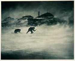
Cape Denison is a rocky point at the head of Commonwealth Bay in George V Land, Antarctica. It was discovered in 1912 by the Australasian Antarctic Expedition (1911–14) under Douglas Mawson, who named it for Sir Hugh Denison of Sydney, a patron of the expedition. The cape was the site of the expedition's main base.[1] Called by Mawson "the windiest place on Earth", the site experiences fierce katabatic winds.[2]

Historic site edit
The site, including Mawson's Huts, Boat Harbour and the historic artefacts contained within its waters, has been designated a Historic Site or Monument (HSM 77), following a proposal by Australia to the Antarctic Treaty Consultative Meeting.[3]

First aeroplane in Antarctica edit
The Air-tractor sledge, the first aeroplane to be brought to Antarctica (in 1912) was stationed at Cape Denison, although it never took to the air on the continent because it was damaged before being shipped there. The aircraft, a Vickers R.E.P. Type Monoplane (the first aircraft type to be built by Vickers) was used briefly as a "propeller driven snow tractor" and then abandoned, as the pistons seized up due to the cold.[4]
Relic found on 1 January 2010 edit
On New Year's Day, 2010, the carpenter of the latest expedition to Cape Denison came across small (150mm) pieces of the fuselage tubing in the harbour at a very low tide (January 2010 was a month with a 'blue moon').[4] The pieces found were cut from the final section of the airframe and constituted the fittings for a rudder. An attempt had been made by Mawson's team to fabricate a metal ice rudder. This device replaced the original rudder (which did not work at the low speeds attained by the air tractor). The original rudder is preserved in Mawson's Hut at Cape Denison, while the ice rudder is in the Antarctic Division at Hobart, Tasmania.
The remains of the fuselage are probably still buried under the ice near Mawson's Huts. The ice is 3m deep and the remains are about 30m from the edge of the harbour. An attempt was to be made in December 2010 to excavate the site – a similar excavation in 2008 nearby did not find any remains, but since then more sophisticated equipment (magnetometer, ground penetrating radar, metal detector, differential GPS, ice drilling) has been used and a more precise position found. However, this work has been delayed, in 2010-11 by logistical constraints, and in 2011-12 and 2012-13 by the presence of giant iceberg B9B which has locked in fast ice and prevented the French Antarctic supply vessel L'Astrolabe from entering Commonwealth Bay.[5][6]
Adélie penguin colony edit
Cape Denison once supported a large colony of Adélie penguins with perhaps 150,000 members. In 2010, a large iceberg trapped the colony, making access to the sea difficult and threatening the lives of all the penguins.[7] By 2013, only 10,000 remained and by 2016, they were reported in danger of being "wiped out".[7] Media reports were exaggerated however and in response, the authors released this update:
It is important to recognise that this study[8] focuses on the Adélie penguin colonies at Cape Denison and the MacKellar Islets, which has been well known, and importantly, well studied over the past century. The study reported here identified that the impact of the iceberg B09B on the penguins since 2010. The number of penguins breeding at these colonies has declined markedly since estimates were first made 100 years ago. However our study concerns only the impact B09B and the associated fast ice that has built up between it and the land since the iceberg stranded in 2010. The penguins now have to commute about 65 km between colonies where they breed and the sea where they can feed. Many fewer penguins are now returning to the colonies to attempt to breed and of those that do return most fail to rear their chicks. We found hundreds of abandoned eggs and thousands of dead chicks. We did not suggest that thousands of adult penguins have died as some media reports suggest. In fact it is unlikely many if any adult penguins have died as a result of this stranding event. We found very few, perhaps no pre-breeding birds at Cape Denison and, if as we predict, few if any young birds prospecting for a place to breed in future are visiting these colonies the local colonies could become extinct within the breeding life of an Adelie penguins (<16 years) if young birds do not replace the old established breeders as they come to the end of their lives." "This iceberg stranding event only affects Adelie penguins in the Commonwealth Bay area, the millions of Adelie penguins breeding around the rest of Antarctica are not affected."[9]
The 102 ha colony site has been designated an Important Bird Area (IBA) by BirdLife International.[10]
References edit
- ^ "Denison, Cape". Geographic Names Information System. United States Geological Survey, United States Department of the Interior. Retrieved 11 January 2012.
- ^ Trewby, M. (Ed., 2002): Antarctica. An encyclopedia from Abbott Ice Shelf to Zooplankton. Firefly Books Ltd. ISBN 1-55297-590-8
- ^ "List of Historic Sites and Monuments approved by the ATCM (2012)" (PDF). Antarctic Treaty Secretariat. 2012. Retrieved 6 January 2014.
- ^ a b "Relic of Antarctica's first plane found on ice-edge". Reuters. 2 January 2010. Archived from the original on 24 September 2015. Retrieved 30 June 2017.
- ^ Mawson's Huts Foundation > Conservation Accessed 11 October 2013
- ^ Mawson's Huts Foundation > News Archived 26 November 2013 at the Wayback Machine Accessed 11 October 2013
- ^ a b Arlington, Kim (12 February 2016). "Giant iceberg could wipe out Adélie penguin colony at Cape Denison, Antarctica".
- ^ Wilson, Kerry-Jayne; Turney, Chris S.M. (February 2016). "The impact of the giant iceberg B09B on population size and breeding success of Adélie penguins in Commonwealth Bay, Antarctica". Antarctic Science. 28 (3). Plus co-authors Christopher J. Fogwill, Estelle Blair: 187–193. Bibcode:2016AntSc..28..187W. doi:10.1017/s0954102015000644. S2CID 31970812.
- ^ https://www.facebook.com/bluepenguintrust/posts/835989556522962 [user-generated source]
- ^ "Cape Denison". BirdLife Data Zone. BirdLife International. 2015. Retrieved 27 October 2020.
![]() This article incorporates public domain material from "Denison, Cape". Geographic Names Information System. United States Geological Survey.
This article incorporates public domain material from "Denison, Cape". Geographic Names Information System. United States Geological Survey.
External links edit
- Key Publishing Ltd Aviation Forums
- Australian Antarctic Division > Home of the Blizzard > Cape Denison: Introduction Accessed 10 October 2013.
67°0′S 142°40′E / 67.000°S 142.667°E