


Summary
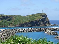
Cape Irizaki (西崎, Irizaki, Yonaguni: Iridati) is the western tip of Yonaguni Island and the westernmost point in Japan. The cape is within the town of Yonaguni, Okinawa.[1][2][3]
Cape Irizaki
西崎 Irizaki | |
|---|---|
 Cape Irizaki | |
 Cape Irizaki  Cape Irizaki | |
| Coordinates: 24°26′58″N 122°56′01″E / 24.44944°N 122.93361°E | |
| Location | Yonaguni, Okinawa, Japan |
| Offshore water bodies | East China Sea |
| Area | |
| • Total | 0.3 km2 (0.12 sq mi)[1][2] |
| Elevation | 50 m (160 ft)[1][2] |
There is a lighthouse, an observation platform, and a monument titled "Monument of the Westernmost Point of Japan" (日本最西端の碑, Nihon Saiseitan no Ishibumi) on the cape. Tourists gather at the cape daily to see the final sunset in Japan.[3][4]

Geography edit
Cape Irizaki is 0.37 kilometres (0.23 mi) wide, 0.7 kilometres (0.43 mi) long, and juts into the East China Sea northwest from Yonaguni Island. The cape reaches a height of 50 metres (164 ft), and is surrounded by sea cliffs. Taiwan, which is about 110 kilometres (59 nmi; 68 mi) to the west, is visible on a clear day. Kubara hill [191.5 metres (628 ft)] and its homonymous fishing port and settlement are visible to the east of the cape. The Black Current flows west of Cape Irizaki to the north, and is a rich fishing ground for marlin and skipjack tuna.[1][2]
Cape Irizaki, like much of the Yaeyama Islands, is composed of sandstone and mudstone. The cape is devoid of trees due to constant strong winds. Unlike other areas of the Yaeyama Islands, Cape Irizaki is surrounded by very little coral reef.[1]
History edit
Cape Irizaki is first mentioned in Shōhō Kuniezu, a kuniezu, or series of Japanese provincial land maps created during the Edo period (1603 – 1868). The Shōhō Kuniezu, which was compiled beginning in 1644, lists the cape as "Ire no Zaki".[1] The cape became the westernmost point of Japan in 1879, when Japan annexed the Ryukyu Kingdom.
Transportation edit
Cape Irizaki is open to the public, and is easily accessible on foot from the settlement of Kuburadake. The cape is approximately one hour by bus from Yonaguni Airport.
References edit
- ^ a b c d e f "西崎" [Irizaki]. Nihon Rekishi Chimei Taikei (in Japanese). Tokyo: Shogakukan. 2013. OCLC 173191044. Archived from the original on 2007-08-25. Retrieved 2013-07-19.
- ^ a b c d "与那国島" [Yonaguni]. Nihon Rekishi Chimei Taikei (in Japanese). Tokyo: Shogakukan. 2012. OCLC 173191044. Archived from the original on 2007-08-25. Retrieved 2012-12-17.
- ^ a b 西崎 [Irizaki] (in Japanese). Yonaguni, Okinawa Prefecture, Japan: Yonagunijima.net. 2013. Retrieved 2013-07-19.
- ^ 西崎 [Irizaki] (in Japanese). Yonaguni, Okinawa Prefecture, Japan: Mitsuharu Kaneko. 2002. Archived from the original on 2014-05-11. Retrieved 2013-07-19.