


Summary
Cape Shionomisaki (潮岬, Shiono-misaki) is a headland located in southern Kii Peninsula in the Kansai Region of Japan. It is located within the borders of the town of Kushimoto in Wakayama Prefecture, and is the most southerly point of the island of Honshu, and Wakayama Prefecture. Much of the cape is also a part of the Yoshino-Kumano National Park. The area is subject to frequent typhoons and the cape is often used as an indicator of the location of typhoons relative to Japan.
Cape Shionomisaki
潮岬 (Shiono-misaki) | |
|---|---|
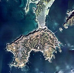 Cape Shionomisaki aerial photograph | |
 Cape Shionomisaki Cape Shionomisaki  Cape Shionomisaki Cape Shionomisaki (Japan) | |
| Coordinates: 33°26′15″N 135°45′16″E / 33.43750°N 135.75444°E | |
| Location | Kushimoto, Wakayama, Japan |
| Offshore water bodies | Pacific Ocean |
Geologically, the cape is a flat uplifted seafood plateau with an elevation of 60 to 80 meters consisting of two marine terraces, and a coastal cliff with a height of 40 meters. Originally an island, gravel from the estuary of nearby rivers is carried by coastal currents to form a sandbar, which now connects the island to land.
Cape Shionomisaki is the location of the Shionomisaki Lighthouse,[1] one of the “50 Lighthouses of Japan” by the Japan Lighthouse Association.[2]
Climate edit
| Climate data for Cape Shionomisaki, Kushimoto (elevation 68 m (223 ft), 1991−2020 normals, extremes 1913−present) | |||||||||||||
|---|---|---|---|---|---|---|---|---|---|---|---|---|---|
| Month | Jan | Feb | Mar | Apr | May | Jun | Jul | Aug | Sep | Oct | Nov | Dec | Year |
| Record high °C (°F) | 23.6 (74.5) |
23.4 (74.1) |
23.9 (75.0) |
26.2 (79.2) |
29.4 (84.9) |
30.8 (87.4) |
35.6 (96.1) |
36.1 (97.0) |
33.8 (92.8) |
29.7 (85.5) |
27.2 (81.0) |
23.3 (73.9) |
36.1 (97.0) |
| Mean daily maximum °C (°F) | 11.4 (52.5) |
12.4 (54.3) |
15.2 (59.4) |
18.8 (65.8) |
22.5 (72.5) |
24.7 (76.5) |
28.2 (82.8) |
29.8 (85.6) |
27.6 (81.7) |
23.2 (73.8) |
18.7 (65.7) |
13.8 (56.8) |
20.5 (68.9) |
| Daily mean °C (°F) | 8.3 (46.9) |
8.8 (47.8) |
11.6 (52.9) |
15.6 (60.1) |
19.3 (66.7) |
22.1 (71.8) |
25.7 (78.3) |
26.9 (80.4) |
24.6 (76.3) |
20.3 (68.5) |
15.5 (59.9) |
10.6 (51.1) |
17.5 (63.5) |
| Mean daily minimum °C (°F) | 5.2 (41.4) |
5.3 (41.5) |
8.2 (46.8) |
12.3 (54.1) |
16.6 (61.9) |
19.9 (67.8) |
23.8 (74.8) |
24.8 (76.6) |
22.1 (71.8) |
17.7 (63.9) |
12.4 (54.3) |
7.5 (45.5) |
14.6 (58.3) |
| Record low °C (°F) | −3.6 (25.5) |
−5.0 (23.0) |
−2.2 (28.0) |
1.5 (34.7) |
7.3 (45.1) |
12.5 (54.5) |
15.3 (59.5) |
18.1 (64.6) |
14.2 (57.6) |
7.7 (45.9) |
2.5 (36.5) |
−2.0 (28.4) |
−5.0 (23.0) |
| Average precipitation mm (inches) | 97.7 (3.85) |
118.1 (4.65) |
185.5 (7.30) |
212.3 (8.36) |
236.7 (9.32) |
364.7 (14.36) |
298.4 (11.75) |
260.3 (10.25) |
339.2 (13.35) |
286.6 (11.28) |
152.0 (5.98) |
102.9 (4.05) |
2,654.3 (104.50) |
| Average precipitation days (≥ 0.5 mm) | 7.1 | 8.3 | 11.8 | 11.4 | 11.9 | 15.8 | 12.9 | 12.4 | 13.2 | 12.0 | 9.3 | 7.0 | 133.1 |
| Average relative humidity (%) | 58 | 58 | 62 | 68 | 75 | 84 | 86 | 84 | 78 | 72 | 64 | 60 | 71 |
| Mean monthly sunshine hours | 192.5 | 187.9 | 198.6 | 201.9 | 193.2 | 132.4 | 193.2 | 234.8 | 176.8 | 169.8 | 177.5 | 194.0 | 2,255.9 |
| Source: Japan Meteorological Agency[3][4] | |||||||||||||
Gallery edit
-
 Shionomisaki Lighthouse
 -
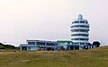 Shionomisaki Tower
 -
 Monument marking the southernmost point of Honshu
 -
 Nanki Kumano Geopark Center


References edit
- ^ 串本町観光協会, ed. (June 2014). "潮岬灯台" (in Japanese). Archived from the original on 22 May 2015. Retrieved 14 August 2015..
- ^ Japan Lighthouse Association home page Archived 2018-04-05 at the Wayback Machine (in Japanese)
- ^ "平年値ダウンロード". Japan Meteorological Agency. Archived from the original on July 26, 2021. Retrieved June 1, 2021.
- ^ "観測史上1〜10位の値(年間を通じての値)". Japan Meteorological Agency. Retrieved June 1, 2021.
External links edit
- Kushimoto Tourist Information