
KNOWPIA
WELCOME TO KNOWPIA

Capelle-Fermont 
Summary
Capelle-Fermont (French pronunciation: [kapɛl fɛʁmɔ̃]) is a commune in the Pas-de-Calais department in the Hauts-de-France region of France.[3]
Capelle-Fermont | |
|---|---|
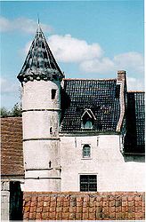 Manor | |
 Coat of arms | |
Location of Capelle-Fermont .mw-parser-output .locmap .od{position:absolute}.mw-parser-output .locmap .id{position:absolute;line-height:0}.mw-parser-output .locmap .l0{font-size:0;position:absolute}.mw-parser-output .locmap .pv{line-height:110%;position:absolute;text-align:center}.mw-parser-output .locmap .pl{line-height:110%;position:absolute;top:-0.75em;text-align:right}.mw-parser-output .locmap .pr{line-height:110%;position:absolute;top:-0.75em;text-align:left}.mw-parser-output .locmap .pv>div{display:inline;padding:1px}.mw-parser-output .locmap .pl>div{display:inline;padding:1px;float:right}.mw-parser-output .locmap .pr>div{display:inline;padding:1px;float:left}html.skin-theme-clientpref-night .mw-parser-output .od,html.skin-theme-clientpref-night .mw-parser-output .od .pv>div,html.skin-theme-clientpref-night .mw-parser-output .od .pl>div,html.skin-theme-clientpref-night .mw-parser-output .od .pr>div{background:#000;color:#fff}html.skin-theme-clientpref-night .mw-parser-output .locmap{filter:grayscale(0.6)}@media(prefers-color-scheme:dark){html.skin-theme-clientpref-os .mw-parser-output .locmap{filter:grayscale(0.6)}html.skin-theme-clientpref-os .mw-parser-output .od,html.skin-theme-clientpref-os .mw-parser-output .od .pv>div,html.skin-theme-clientpref-os .mw-parser-output .od .pl>div,html.skin-theme-clientpref-os .mw-parser-output .od .pr>div{background:#000;color:#fff}}  Capelle-Fermont  Capelle-Fermont | |
| Coordinates: 50°21′10″N 2°37′01″E / 50.3528°N 2.6169°E | |
| Country | France |
| Region | Hauts-de-France |
| Department | Pas-de-Calais |
| Arrondissement | Arras |
| Canton | Avesnes-le-Comte |
| Intercommunality | CC Campagnes de l'Artois |
| Government | |
| • Mayor (2020–2026) | Sabine Surelle[1] |
| Area 1 | 2.96 km2 (1.14 sq mi) |
| Population (2021)[2] | 219 |
| • Density | 74/km2 (190/sq mi) |
| Time zone | UTC+01:00 (CET) |
| • Summer (DST) | UTC+02:00 (CEST) |
| INSEE/Postal code | 62211 /62690 |
| Elevation | 82–122 m (269–400 ft) (avg. 88 m or 289 ft) |
| 1 French Land Register data, which excludes lakes, ponds, glaciers > 1 km2 (0.386 sq mi or 247 acres) and river estuaries. | |
Geography edit
A small village located 10 miles (16 km) northwest of Arras on the D49 road in the Scarpe valley.,
Population edit
| Year | Pop. | ±% p.a. |
|---|---|---|
| 1968 | 92 | — |
| 1975 | 83 | −1.46% |
| 1982 | 105 | +3.42% |
| 1990 | 126 | +2.31% |
| 1999 | 127 | +0.09% |
| 2007 | 184 | +4.74% |
| 2012 | 200 | +1.68% |
| 2017 | 217 | +1.64% |
| Source: INSEE[4] | ||
Places of interest edit
- The church of Notre-Dame, dating from the eleventh century.
- The manor house of Capelle Fermont
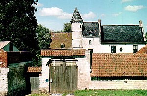
The walls bear the arms of Jean Grenet, a mayor of Arras, who died in 1539. The mansion was restored in 1701 by the Preudhomme de Haillies family.
See also edit
References edit
- ^ "Répertoire national des élus: les maires". data.gouv.fr, Plateforme ouverte des données publiques françaises (in French). 9 August 2021.
- ^ "Populations légales 2021". The National Institute of Statistics and Economic Studies. 28 December 2023.
- ^ INSEE commune file
- ^ Population en historique depuis 1968, INSEE
Wikimedia Commons has media related to Capelle-Fermont.