


Summary
Caravonica is a suburb of Cairns in the Cairns Region, Queensland, Australia.[2] In the 2016 census, Caravonica had a population of 1,989 people.[1]
| Caravonica Cairns, Queensland | |||||||||||||||
|---|---|---|---|---|---|---|---|---|---|---|---|---|---|---|---|
 Caravonica and the suburbs to the south east | |||||||||||||||
 Caravonica | |||||||||||||||
 | |||||||||||||||
| Coordinates | 16°51′43″S 145°40′58″E / 16.8619°S 145.6827°E | ||||||||||||||
| Population | 1,989 (2016 census)[1] | ||||||||||||||
| • Density | 432/km2 (1,120/sq mi) | ||||||||||||||
| Postcode(s) | 4878 | ||||||||||||||
| Area | 4.6 km2 (1.8 sq mi) | ||||||||||||||
| Time zone | AEST (UTC+10:00) | ||||||||||||||
| LGA(s) | Cairns Region | ||||||||||||||
| State electorate(s) | Barron River | ||||||||||||||
| Federal division(s) | Leichhardt | ||||||||||||||
| |||||||||||||||
Caranovica is approximately 11 kilometres (6.8 mi) from the Cairns city centre.
Geography edit
Caravonica lies in the foothills of the Queensland tropical rain forests. The actual village itself is 1.2 kilometres (0.75 mi) in length from its most northern point to its most southern point. The boundary of the suburb can be found as far north as the Tjapukai Aboriginal Cultural Park and the Skyrail Rainforest Cableway's southern terminal is known as the Caravonica Terminal. The southern border is bounded by Kamerunga, aligning with the Barron River riparian zone along the Kamerunga section of the northern bank of the river.[3]
Lake Placid is a neighbourhood within the locality. Formerly known as Barron Waters,[4] it is named after a natural pond in the Barron River, created by a rock barrage.[5] Lake Placid is the entrance to the Barron Gorge National Park.[6]
A supplementary section of Lake Placid Road leads to Kamerunga Conservation Park and Kamerunga Crossing, a ford across the Barron River. It is the location of an old bridge (no longer for use by vehicles).[7][8]
Maps edit
-
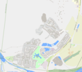 Map of Caravonica
 -
 Map of Caravonica in the Region of Cairns


History edit
Caravonica is situated in the Djabugay (Tjapukai) traditional Aboriginal country. The Yirrganydji people are custodians within the Djabugay traditional country[9]
The origin of the suburb name is from the town of Caravonica in Italy, named in the 1880s after the hometown of David Thomatis.[10]
Caravonica was originally part of the Shire of Mulgrave and then the City of Cairns local government areas.
Kamerunga State School opened on 28 May 1913. It was wrecked in a cyclone in February 1927. On 6 April 1927 it reopened at a new location as Caravonica State School.[11] The decision to relocate the school had been taken prior to the cyclone.[12][13]
Lake Placid was originally called Barron Waters but was renamed in 1969.[4] It is named after a natural pond in the Barron River, created by a rock barrage.[5]
In the 2016 census, Caravonica had a population of 1,989 people.[1]
Community groups edit
The Smithfield branch of the Queensland Country Women's Association meets at the CWA Hall on Kamerunga Road, Caravonica. It is between the Caravonica State School and the Australian Armour and Artillery Museum.[14]
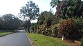
Images edit
-
 Aarona Street – a typical street
 -
 View cross suburbia from Kwana Street
 -
 Kwana Street
 -
 Suburban landscape with Red Peak


References edit
- ^ a b c Australian Bureau of Statistics (27 June 2017). "Caravonica (SSC)". 2016 Census QuickStats. Retrieved 20 October 2018.
- ^ "Caravonica – suburb in Cairns Region (entry 48562)". Queensland Place Names. Queensland Government. Retrieved 18 September 2020.
- ^ "Queensland Globe; Layer:Boundaries".
- ^ a b "Lake Placid – locality unbounded in Cairns Regional (entry 18821)". Queensland Place Names. Queensland Government. Retrieved 18 September 2020.
- ^ a b "Cairns, tropical city in Far North Queensland". Oz Outback. Archived from the original on 25 June 2004. Retrieved 21 July 2007.
- ^ "Reflections on the Lake". Reflections on the Lake Restaurant. Archived from the original on 29 February 2004. Retrieved 21 July 2007.
- ^ "Kamerunga Crossing – ford in Cairns Regional (entry 17625)". Queensland Place Names. Queensland Government. Retrieved 18 September 2020.
- ^ "Google Streetview". Google Maps. Retrieved 6 October 2020.
- ^ "First people cultural history". Cairns Regional Council. Archived from the original on 9 April 2020. Retrieved 23 June 2020.
- ^ "C Suburbs" (PDF). Cairns Regional Council.
- ^ Queensland Family History Society (2010), Queensland schools past and present (Version 1.01 ed.), Queensland Family History Society, ISBN 978-1-921171-26-0
- ^ "Appalling Damage". Daily Standard. No. 4405. Queensland, Australia. 23 February 1927. p. 4 (Second Edition – 3 p.m.). Retrieved 25 December 2020 – via National Library of Australia.
- ^ "Blown Down". The Northern Herald. Vol. LVI, no. 727. Queensland, Australia. 9 March 1927. p. 23. Retrieved 25 December 2020 – via National Library of Australia.
- ^ "Branch Locations". Queensland Country Women's Association. Archived from the original on 26 December 2018. Retrieved 26 December 2018.
External links edit
![]() Media related to Caravonica, Queensland at Wikimedia Commons
Media related to Caravonica, Queensland at Wikimedia Commons
- Tjapukai Aboriginal Cultural Park