


Summary
The Carmel Formation is a geologic formation in the San Rafael Group that is spread across the U.S. states of Wyoming, Utah, Colorado, north east Arizona and New Mexico. Part of the Colorado Plateau, this formation was laid down in the Middle Jurassic during the late Bajocian, through the Bathonian and into the early Callovian stages.[2]
| Carmel Formation | |
|---|---|
| Stratigraphic range: | |
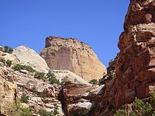
 Carmel Formation at its type location, Mount Carmel, Utah | |
| Type | Geological formation |
| Unit of | San Rafael Group |
| Underlies | Entrada Sandstone |
| Overlies | Navajo Sandstone, Temple Cap Formation, Nugget Sandstone |
| Thickness | From 200 feet (60 m) to 1,000 feet (300 m)[1] |
| Lithology | |
| Primary | Mudstone |
| Other | Sandstone, siltstone, limestone |
| Location | |
| Coordinates | 37°15′04″N 112°39′47″W / 37.251°N 112.663°W |
| Region | Wyoming, Utah, Colorado, north east Arizona and New Mexico |
| Country | US |
| Type section | |
| Named for | Mount Carmel |
| Named by | Gilluly and Reeside |
| Year defined | 1928 |
 Carmel Formation (the United States)  Carmel Formation (Utah) | |


Description edit
The Carmel Formation consists of up to 1,000 feet (300 m) of mudrock and sandstone interbedded with limestone and gypsum. It was laid down in a shallow marine to sabkha environment,[1] into which terrigenous sediment was periodically carried. This gives the formation considerable lithological complexity.[3] The formation is underlain by the Navajo Sandstone, with the regional J-2 unconformity separating the two formations, or by the Temple Cap Formation. Portions of the Carmel Formation grade laterally eastward into the Page Sandstone.[2] The Carmel Formation in turn is overlain by the Entrada Formation.[3]
In the type area of southern Utah, the Carmel Formation is divided into the Judd Hollow Member, a basal limestone member; the Crystal Creek Member, mostly mudstone and siltstone, which grades into the Page Sandstone to the east; the Paria River Member, which is also siltstone and mudstone but is separated from the Crystal Creek Member by gypsum beds; and the Winsor Member, which is mudstone, sandstone, and siltstone separated from the Paria River by a basal limestone. Further east, the limestone marker bed pinches out, and the Winsor Member and Paria River Member become indistinguishable and are informally termed the upper member. The upper member contains volcaniclastic beds of rhyolite originating in a volcanic arc just off the edge of the Colorado Plateau.[4]
The formation preserves a Jurassic hardground, rare for North America.[5]
Subunits edit
Members (alphabetical):
- Co-op Creek Limestone Member (UT) (in place of the preempted name Kolob Limestone Member)[6]
- Crystal Creek Member (UT)[6]
- Homestake Limestone Member (UT*)[7]
- Judd Hollow Member (AZ*, UT*) or Judd Hollow Tongue (AZ*, UT*)[2]
- Paria River Member (UT*)[8]
- Wiggler Wash Member (UT*)[8]
- Winsor Member (UT*)[8]
(Asterisks mean the name is used by the US Geological Survey)[9]
History of investigation edit
In 1928 Gilluly and Reeside stated an intent to name the formation after the village of Mount Carmel, Utah but did not give a type locality. They noted it as a basal formation in the San Rafael Group in San Rafael Swell, in Emery County, Utah.[10] An overview along with a type locality and source of name was stated by Gregory and Moore in 1931.[11] Mackin revised the formation's description and assigned the Homestake Limestone Member to it in 1954.[12] Harshbarger and others created an overview in 1957.[13] Its eastern areal limits were described by Wright and others in 1962.[14] In 1963, western areal limits along with an overview were completed by Schultz and Wright.[15] Another revision was done by Phoenix in 1963 who also added a Judd Hollow Tongue member.[16] Isotopic dating was conducted by Marvin and others in 1965. The Kolob, Crystal Creek, Paria River, Winsor, and Wiggler Wash members were assigned by Thompson and Stokes in 1970. Areal limits were adjusted by O'Sullivan and Craig in 1973[17] and again in 1983 by Blakey and others.[3] An overview was completed by Chapman in 1989.[4] Hintze and others conducted isotopic dating and created an overview in 1994.[18]
Paleontological finds edit
There have been a number of paleontological finds within the Carmel Formation. Among these have been bryozoans,[19] oysters,[5] and dinosaur footprints.[20]
Hardground mollusc community edit
The formation preserves a rare Jurassic hardground interpreted as a carbonate lagoon between oolitic shoals and a subtidal zone. The hardground community was dominated by bivalves such as Liostrea, Plicatula, and Modiolus. The ichnofossil Gastro‐chaenolites is present, often with fossils of Lithophaga preserved inside. The rare bryozoan Arachnidium is found in attachment scars of Liostrea. Though bivalves were abundant, the community is lacking in the diversity seen in other Jurassic hardgrounds, suggesting a restricted shelf environment.[5]
Bryozoans edit
Bryozoans found within the Carmel Formation include seven species of calcareous cyclostome bryozoans as well as a soft-bodied ctenostome bryozoan.[19]
Gallery edit
-
 Cross-section of a carbonate hardground encrusted by oysters and bored by bivalves (Gastrochaenolites)
 -
 Biosparite/grainstone with crinoid columnals (Isocrinus nicoleti) from the Carmel Formation at Mount Carmel Junction, Utah.
 -
 Ripplemarks in a biosparite/grainstone from the Carmel Formation, southwestern Utah.
 -
 Ooids and crinoid columnals (Isocrinus nicoleti) on the surface of Carmel Formation limestone.
 -
 Ostreolith ("oyster ball") from the Carmel Formation, southwestern Utah.
 -
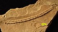 Trace fossil Gyrochorte from the Carmel Formation (Middle Jurassic) of SW Utah.


Places found edit
Geologic Province:[9]
- Black Mesa Basin*[21]
- Capitol Reef National Park
- Great Basin province*[2]
- Green River Basin*[22]
- Paradox Basin*[2]
- Plateau sedimentary province*[2]
- San Juan Basin[21]
- Uinta Basin*
- Uinta Uplift*
References edit
- ^ a b "Carmel Formation (in San Rafael Group)". 6 September 2015. Archived from the original on 4 March 2016. Retrieved 6 September 2015.
- ^ a b c d e f Peterson, F.; Pipiringos, G.N. (1979). "Stratigraphic relations of the Navajo Sandstone to Middle Jurassic formations, southern Utah and northern Arizona". United States Geological Survey Professional Paper. 1035-B. doi:10.3133/pp1035B.
- ^ a b c Blakey, R.C.; Peterson, Fred; Caputo, M.V.; Voorhees, B.J.; Geddes, D.J.; Geesaman, R.C. (1983). "Paleogeography of Middle Jurassic continental, shoreline, and shallow marine sedimentation, southern Utah". Society of Economic Paleontologists and Mineralogists, Rocky Mountain Section, Rocky Mountain Paleogeography Symposium. 2: 77–100. Retrieved 26 October 2021.
- ^ a b Chapman, Mary G. (1 March 1989). "Implications of rhyolitic ignimbrite boulders in the Middle Jurassic Carmel Formation of southern Utah". Geology. 17 (3): 281–284. doi:10.1130/0091-7613(1989)017<0281:IORIBI>2.3.CO;2.
- ^ a b c Wilson, Mark A.; Palmer, Timothy J. (January 1994). "A carbonate hardground in the Carmel Formation (middle Jurassic, SW Utah, USA) and its associated encrusters, borers and nestlers". Ichnos. 3 (2): 79–87. doi:10.1080/10420949409386375.
- ^ a b Doelling, H.H.; Davis, F.D. (1989). "The geology of Kane County, Utah". Utah Geological and Mineral Survey Bulletin. 124. Retrieved 25 October 2021.
- ^ Leith, C.K.; Harder, E.C. (1908). "The iron ores of the Iron Springs district, southern Utah". United States Geological Survey Bulletin. 338. doi:10.3133/b338. hdl:2346/64975.
- ^ a b c Thompson, A.E.; Stokes, W.L. (1970). "Stratigraphy of the San Rafael Group, southwest and south central Utah". Utah Geological and Mineral Survey Bulletin. 87.
- ^ a b GEOLEX database entry for Carmel, USGS (viewed 20 March 2006)
- ^ Gilluly, J.; Reeside, J.B. Jr. (1928). "Sedimentary rocks of the San Rafael Swell and some adjacent areas in eastern Utah". United States Geological Survey Professional Paper. 150-D: 73–76. doi:10.3133/pp150D.
- ^ Gregory, H.C.; Moore, R.C. (1931). "The Kaiparowits Region: A Geographic and Geologic Reconnaissance of Parts of Utah and Arizona". United States Geological Survey Professional Paper. 164: 72–77. doi:10.3133/pp164. hdl:2027/uc1.32106006462755.
- ^ Mackin, J.H. (1954). "Geology and iron ore deposits of the Granite Mountain area, Iron County, Utah". U.S. Geological Survey Miscellaneous Field Studies Map. MF-I4. doi:10.3133/mf14.
- ^ Harshbarger, J.W.; Repenning, C.A.; Irwin, J.H. (1957). "Stratigraphy of the uppermost Triassic and the Jurassic rocks of the Navajo country". United States Geological Survey Professional Paper. 291. doi:10.3133/pp291.
- ^ Wright, J.C.; Shawe, D.R.; Lohman, S.W. (1962). "Definition of Members of Jurassic Entrada Sandstone in East-Central Utah and West-Central Colorado". AAPG Bulletin. 46. doi:10.1306/BC74394B-16BE-11D7-8645000102C1865D.
- ^ Schultz, L.G.; Wright, J.C. (1963). "Bentonite beds of unusual composition in the Carmel Formation, southwest Utah". U.S. Geological Survey Professional Paper. 450-E (198): E67–E72. doi:10.3133/pp450E.
- ^ Phoenix, D.A. (1963). "Geology of the Lees Ferry area, Coconino County, Arizona". United States Geological Survey Bulletin. 1137: 32–35. doi:10.3133/b1137.
- ^ Marvin, R.F.; Wright, J.C.; Walthall, F.G. (1965). "K-Ar and Rb-Sr ages of biotite from the Middle Jurassic part of the Carmel Formation, Utah". United States Geological Survey Professional Paper. 525-B: B104–B107. doi:10.3133/pp525B.
- ^ Hintze, L.F.; Anderson, R.E.; Embree, G.F. (1994). "Geologic map of the Motoqua and Gunlock quadrangles, Washington County, Utah". U.S. Geological Survey Miscellaneous Investigations Series Map. I-2427. Retrieved 26 October 2021.
- ^ a b Taylor, Paul D.; Wilson, Mark A. (September 1999). "Middle Jurassic bryozoans from the Carmel Formation of southwestern Utah". Journal of Paleontology. 73 (5): 816–830. doi:10.1017/S0022336000040671.
- ^ Lockley, Martin; Hunt, Adrian; Paquette, Marc; Bilbey, Sue‐Ann; Hamblin, Alden (July 1998). "Dinosaur tracks from the Carmel formation, northeastern Utah: Implications for middle Jurassic paleoecology". Ichnos. 5 (4): 255–267. doi:10.1080/10420949809386424.
- ^ a b O'Sullivan, R.B.; Craig, L.C. (1973). "Jurassic rocks of northeast Arizona and adjacent areas" (PDF). New Mexico Geological Society Field Conference Guidebook. 24: 79–85. Retrieved 25 October 2021.
- ^ Rowley, P.D.; Hansen, W.R. (1979). "Geologic map of the Plug Hat quadrangle, Moffat County, Colorado". U.S. Geological Survey Geologic Quadrangle Map. GQ-1514. Retrieved 25 October 2021.
External links edit
 Media related to Carmel Formation at Wikimedia Commons