


Summary
The Carroll Street station is a local station on the IND Culver Line of the New York City Subway, located in the neighborhood of Carroll Gardens, Brooklyn, at Carroll and Smith Streets. It is served by the F and G trains at all times.
Carroll Street | ||||||||||||||||||||||||||||||||||||||||||||||||||||||||||||||||||||
|---|---|---|---|---|---|---|---|---|---|---|---|---|---|---|---|---|---|---|---|---|---|---|---|---|---|---|---|---|---|---|---|---|---|---|---|---|---|---|---|---|---|---|---|---|---|---|---|---|---|---|---|---|---|---|---|---|---|---|---|---|---|---|---|---|---|---|---|---|
 Southbound platform | ||||||||||||||||||||||||||||||||||||||||||||||||||||||||||||||||||||
| Station statistics | ||||||||||||||||||||||||||||||||||||||||||||||||||||||||||||||||||||
| Address | Carroll Street & Smith Street Brooklyn, NY 11231 | |||||||||||||||||||||||||||||||||||||||||||||||||||||||||||||||||||
| Borough | Brooklyn | |||||||||||||||||||||||||||||||||||||||||||||||||||||||||||||||||||
| Locale | Carroll Gardens | |||||||||||||||||||||||||||||||||||||||||||||||||||||||||||||||||||
| Coordinates | 40°40′49″N 73°59′41″W / 40.6802°N 73.9948°W | |||||||||||||||||||||||||||||||||||||||||||||||||||||||||||||||||||
| Division | B (IND)[1] | |||||||||||||||||||||||||||||||||||||||||||||||||||||||||||||||||||
| Line | IND Culver Line | |||||||||||||||||||||||||||||||||||||||||||||||||||||||||||||||||||
| Services | F G | |||||||||||||||||||||||||||||||||||||||||||||||||||||||||||||||||||
| Transit | ||||||||||||||||||||||||||||||||||||||||||||||||||||||||||||||||||||
| Structure | Underground | |||||||||||||||||||||||||||||||||||||||||||||||||||||||||||||||||||
| Platforms | 2 side platforms | |||||||||||||||||||||||||||||||||||||||||||||||||||||||||||||||||||
| Tracks | 4 | |||||||||||||||||||||||||||||||||||||||||||||||||||||||||||||||||||
| Other information | ||||||||||||||||||||||||||||||||||||||||||||||||||||||||||||||||||||
| Opened | October 7, 1933 | |||||||||||||||||||||||||||||||||||||||||||||||||||||||||||||||||||
| Opposite- direction transfer | Yes | |||||||||||||||||||||||||||||||||||||||||||||||||||||||||||||||||||
| Traffic | ||||||||||||||||||||||||||||||||||||||||||||||||||||||||||||||||||||
| 2023 | 2,625,017[2] | |||||||||||||||||||||||||||||||||||||||||||||||||||||||||||||||||||
| Rank | 125 out of 423[2] | |||||||||||||||||||||||||||||||||||||||||||||||||||||||||||||||||||
| ||||||||||||||||||||||||||||||||||||||||||||||||||||||||||||||||||||
| ||||||||||||||||||||||||||||||||||||||||||||||||||||||||||||||||||||
| ||||||||||||||||||||||||||||||||||||||||||||||||||||||||||||||||||||
| ||||||||||||||||||||||||||||||||||||||||||||||||||||||||||||||||||||
| ||||||||||||||||||||||||||||||||||||||||||||||||||||||||||||||||||||


History edit
One of the goals of Mayor John Hylan's Independent Subway System (IND), proposed in the 1920s, was a line to Coney Island, reached by a recapture of the BMT Culver Line.[4][5] As originally designed, service to and from Manhattan would have been exclusively provided by Culver express trains, while all local service would have fed into the IND Crosstown Line.[6] The line was extended from Bergen Street to Church Avenue on October 7, 1933, including the Carroll Street station.[7][8]
Service patterns edit
The station was originally served by the A train. In 1936, the A was rerouted to the IND Fulton Street Line and was replaced by E trains from the Queens Boulevard Line.[7] In 1937, the connection to the IND Crosstown Line opened and GG (later renamed the G) trains were extended to Church Avenue, complementing the E. In December 1940, after the IND Sixth Avenue Line opened, E trains were replaced by the F, and the GG was cut back to Smith–Ninth Streets.[7] Following the completion of the Culver Ramp in 1954,[9][10] D Concourse Express trains replaced F service to Coney Island.[10][11] In November 1967, the Chrystie Street Connection opened and D trains were rerouted via the Manhattan Bridge and the BMT Brighton Line to Coney Island. F trains were extended once again via the Culver Line.[11][12]
The station acted as a local-only station from 1968 to 1976, when F trains ran express in both directions between Bergen Street and Church Avenue during rush hours.[13][14][6] Express service between Bergen and Church ended in 1976 due to budgetary concerns and passenger complaints.[14][6][15] In July 2019, the MTA revealed plans to restore express service on the Culver Line between Jay Street and Church Avenue. Express service started on September 16, 2019.[16][17]
Station layout edit
| Ground | Street level | Exit/entrance |
| Mezzanine | Fare control, station agent | |
| Platform level | Side platform | |
| Northbound local | ← ← | |
| Northbound express | ← | |
| Southbound express | | |
| Southbound local | | |
| Side platform | ||
The station, located underground, has four tracks and two side platforms.[18] The two center express tracks are at a lower level than the local tracks at the north end, and ramp up to the same level by the southern end. Beyond the station, the four track line ascends onto the only original IND elevated structure, rising above the Gowanus Canal and toward Smith–Ninth Streets, the next station south.
Both platforms have a green trim line with a hunter green border and name tablets reading "CARROLL ST." in white sans-serif lettering on a hunter green background and green border. Small directional and station signs in white lettering on a black background are below the trim line and name tablets. Large square columns painted hunter green run at regular intervals on both platforms, with alternating ones having the standard black station name plate with white lettering. The tiles were part of a color-coded tile system used throughout the IND.[19] The tile colors were designed to facilitate navigation for travelers going away from Lower Manhattan. As such, the green tiles used at the Carroll Street station were originally also used at Bergen Street, the next express station to the north, while a different tile color is used at Seventh Avenue, the next express station to the south.[20][21]
Exits edit
| Exit location[22] | Exit type | Number of exits | Platform served |
|---|---|---|---|
| NW corner of President Street and Smith Street | Staircase | 1 | Southbound |
| NE corner of President Street and Smith Street | Staircase | 1 | Northbound |
| SE corner of President Street and Smith Street | Staircase | 1 | Northbound |
| SE corner of Second Street and Smith Street | Staircase | 1 | Both |
| NW corner of Second Place and Smith Street | Staircase | 1 | Both |
Despite the station name, there are no entrances/exits from Carroll Street. The full-time fare control is at the extreme south end of the station. A single staircase from each platform goes up to a crossover, where a turnstile bank provides entrance/exit to the system and mosaic signs point to the platforms. The mezzanine has a token booth and one staircase to the southeast corner of Second Street and Smith Street while another staircase built inside a building leads to the northwest corner of Second Place and Smith Street.[18]
Both platforms have an un-staffed fare control area at their north ends. Each one has two exit-only turnstiles and one high entry/exit turnstile, all on platform level. The one on the northbound platform has two staircases going up to either eastern corners of Smith and President Streets while the one on the Coney Island-bound platform has one staircase going up to the northwest corner.[22]
-
 Street entrance
 -
 Name tablet mosaic
 -
 Tile caption
 -
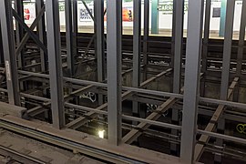 Sunken express tracks
 -
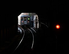 An R68 G train having just left the station


References edit
- ^ "Glossary". Second Avenue Subway Supplemental Draft Environmental Impact Statement (SDEIS) (PDF). Vol. 1. Metropolitan Transportation Authority. March 4, 2003. pp. 1–2. Archived from the original (PDF) on February 26, 2021. Retrieved January 1, 2021.
- ^ a b "Annual Subway Ridership (2018–2023)". Metropolitan Transportation Authority. 2023. Retrieved April 20, 2024.
- ^ "Annual Subway Ridership (2018–2023)". Metropolitan Transportation Authority. 2023. Retrieved April 20, 2024.
- ^ "Plan to Recapture Culver Line Ready" (PDF). The New York Times. July 12, 1932. p. 9. ISSN 0362-4331. Retrieved March 27, 2020.
- ^ "New Subway Routes in Hylan Program to Cost $186,046,000" (PDF). The New York Times. March 21, 1925. p. 1. ISSN 0362-4331. Retrieved March 27, 2020.
- ^ a b c Feasibility and Analysis of F Express Service in Brooklyn (PDF). Metropolitan Transportation Authority (Report). May 2016. Archived (PDF) from the original on May 27, 2016. Retrieved June 24, 2016.
- ^ a b c "Independent Subway Services Beginning in 1932". thejoekorner.com. August 21, 2013. Archived from the original on November 22, 2019. Retrieved August 2, 2015.
Information adapted from:- New York Division Bulletin (Report) (October and November 1968 ed.). Electric Railroaders’ Association, Inc. Fall 1968.
- ^ "City Subway Extended" (PDF). The New York Times. October 7, 1933. p. 16. ISSN 0362-4331. Retrieved December 18, 2018.
- ^ "NYCTA- Pass for Culver Line Ceremonies - 1954". flickr.com. New York City Transit Authority. 1954. Retrieved August 14, 2016.
- ^ a b "Adequate Transit Promised For City" (PDF). The New York Times. October 29, 1954. p. 25. ISSN 0362-4331. Retrieved April 23, 2018.
- ^ a b Sparberg, Andrew J. (October 1, 2014). From a Nickel to a Token: The Journey from Board of Transportation to MTA. Fordham University Press. ISBN 978-0-8232-6190-1.
- ^ Perlmutter, Emanuel (November 16, 1967). "Subway Changes To Speed Service" (PDF). The New York Times. ISSN 0362-4331. Retrieved April 23, 2018.
- ^ "'F' Line Rush-Hour Service Will Be Added in Brooklyn" (PDF). The New York Times. June 8, 1969. ISSN 0362-4331. Retrieved August 26, 2016.
- ^ a b Review of F Line Operations, Ridership, and Infrastructure (PDF). nysenate.gov (Report). MTA New York City Transit Authority. October 7, 2009. Archived from the original (PDF) on May 31, 2010. Retrieved July 28, 2015.
- ^ Geberer, Raanan (March 6, 2013). "Light at End of Tunnel: F Train Express may return". Brooklyn Daily Eagle. Archived from the original on March 27, 2020. Retrieved July 28, 2015.
- ^ Barone, Vincent (July 9, 2019). "Limited F express service coming to Brooklyn for rush hour". AMNY. Archived from the original on October 3, 2019. Retrieved July 9, 2019.
- ^ "MTA NYC Transit Adding Limited F Express Service for Brooklyn Residents with Longest Commutes" (Press release). New York City Transit. July 10, 2019. Archived from the original on September 14, 2019. Retrieved July 10, 2019.
- ^ a b "Review of the G Line: Appendices" (PDF). Metropolitan Transportation Authority. July 10, 2013. Retrieved October 28, 2015.
- ^ "Tile Colors a Guide in the New Subway; Decoration Scheme Changes at Each Express Stop to Tell Riders Where They Are". The New York Times. August 22, 1932. ISSN 0362-4331. Archived from the original on July 1, 2022. Retrieved July 1, 2022.
- ^ Carlson, Jen (February 18, 2016). "Map: These Color Tiles In The Subway System Used To Mean Something". Gothamist. Retrieved May 10, 2023.
- ^ Gleason, Will (February 18, 2016). "The hidden meaning behind the New York subway's colored tiles". Time Out New York. Retrieved May 10, 2023.
- ^ a b "MTA Neighborhood Maps: Red Hook" (PDF). mta.info. Metropolitan Transportation Authority. 2015. Retrieved August 2, 2015.
External links edit
- nycsubway.org – IND Crosstown: Carroll Street
- Station Reporter — F Train
- Station Reporter — G Train
- The Subway Nut — Carroll Street Pictures Archived January 5, 2018, at the Wayback Machine
- President Street entrance from Google Maps Street View
- Second Street entrance from Google Maps Street View
- Second Place entrance from Google Maps Street View
- Platforms from Google Maps Street View